Plains Topo Map Montana
To zoom in, hover over the map of Plains
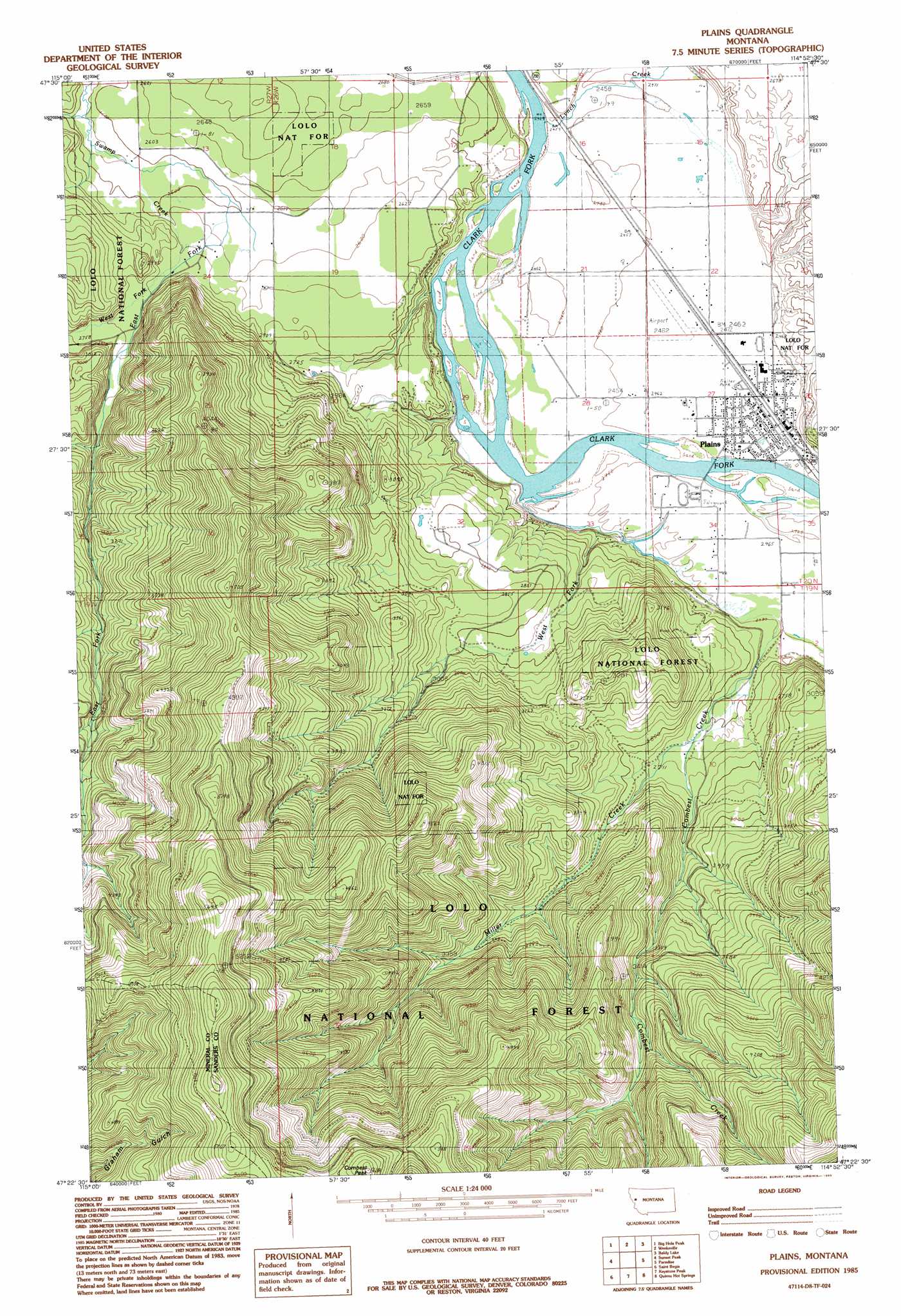
USGS Topo Quad 47114d8 - 1:24,000 scale
| Topo Map Name: | Plains |
| USGS Topo Quad ID: | 47114d8 |
| Print Size: | ca. 21 1/4" wide x 27" high |
| Southeast Coordinates: | 47.375° N latitude / 114.875° W longitude |
| Map Center Coordinates: | 47.4375° N latitude / 114.9375° W longitude |
| U.S. State: | MT |
| Filename: | o47114d8.jpg |
| Download Map JPG Image: | Plains topo map 1:24,000 scale |
| Map Type: | Topographic |
| Topo Series: | 7.5´ |
| Map Scale: | 1:24,000 |
| Source of Map Images: | United States Geological Survey (USGS) |
| Alternate Map Versions: |
Plains MT 1985, updated 1985 Download PDF Buy paper map Plains MT 1999, updated 2003 Download PDF Buy paper map Plains MT 2011 Download PDF Buy paper map Plains MT 2014 Download PDF Buy paper map |
| FStopo: | US Forest Service topo Plains is available: Download FStopo PDF Download FStopo TIF |
1:24,000 Topo Quads surrounding Plains
Priscilla Peak |
Calico Creek |
Loneman Creek |
Coney Peak |
Lonepine |
Eddy Mountain |
Big Hole Peak |
Weeksville |
Baldy Lake |
Hot Springs |
Penrose Peak |
Sunset Peak |
Plains |
Paradise |
Sunrise Spring |
Boyd Mountain |
Saint Regis |
Keystone Peak |
Quinns Hot Springs |
Knowles |
Torino Peak |
Wilson Gulch |
Superior |
Idaho Gulch |
Horsehead Peak |
> Back to 47114a1 at 1:100,000 scale
> Back to 47114a1 at 1:250,000 scale
> Back to U.S. Topo Maps home
Plains topo map: Gazetteer
Plains: Airports
Clark Fork Valley Hospital Heliport elevation 756m 2480′Plains Airport elevation 753m 2470′
Plains: Guts
Pardee Slough elevation 746m 2447′Plains: Mines
Lower Lettermen Mine elevation 807m 2647′Montro Gold Mine elevation 857m 2811′
Upper Lettermen Mine elevation 835m 2739′
Plains: Populated Places
Plains elevation 755m 2477′Plains: Post Offices
Plains Post Office elevation 755m 2477′Plains: Streams
Combest Creek elevation 745m 2444′East Fork Swamp Creek elevation 824m 2703′
Lynch Creek elevation 744m 2440′
Miller Creek elevation 803m 2634′
West Fork Combest Creek elevation 751m 2463′
West Fork Swamp Creek elevation 824m 2703′
Plains: Summits
Combest Peak elevation 1707m 5600′Plains: Wells
19N26W03ACBC01 Well elevation 787m 2582′19N26W03BDAC01 Well elevation 794m 2604′
20N26W15ACAB01 Well elevation 755m 2477′
20N26W15BAAD01 Well elevation 754m 2473′
20N26W16BADA01 Well elevation 754m 2473′
20N26W23CCBA01 Well elevation 757m 2483′
20N26W27DBBC01 Well elevation 754m 2473′
20N26W27DDBC01 Well elevation 752m 2467′
20N27W13DDCD01 Well elevation 796m 2611′
20N27W24BDBC01 Well elevation 808m 2650′
Plains digital topo map on disk
Buy this Plains topo map showing relief, roads, GPS coordinates and other geographical features, as a high-resolution digital map file on DVD: