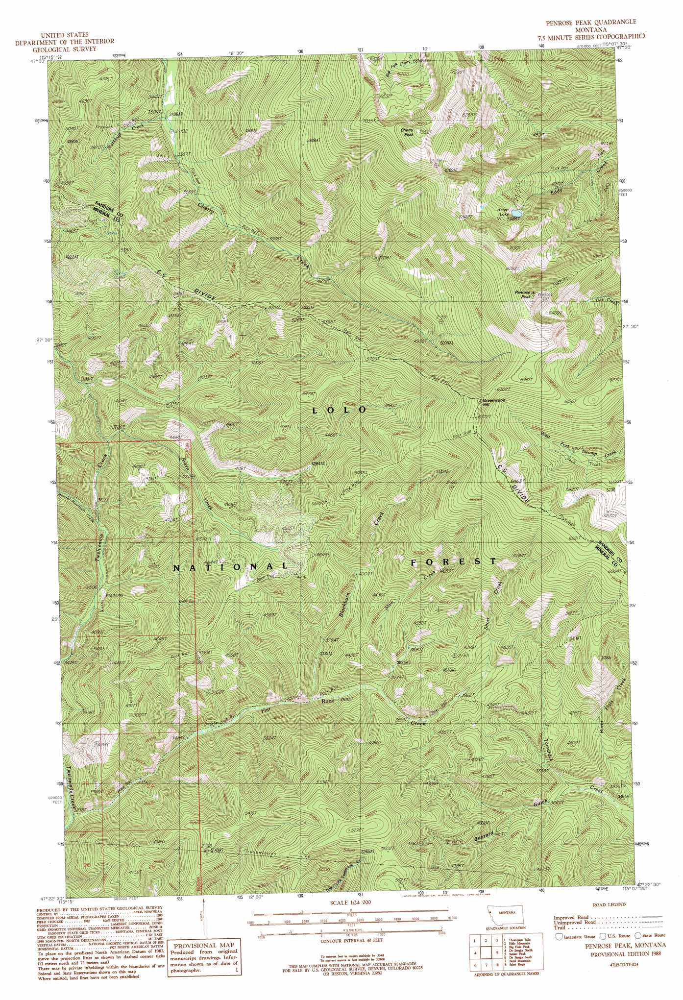
Penrose Peak Topo Map Montana
To zoom in, hover over the map of Penrose Peak
USGS Topo Quad 47115d2 - 1:24,000 scale
| Topo Map Name: | Penrose Peak |
| USGS Topo Quad ID: | 47115d2 |
| Print Size: | ca. 21 1/4" wide x 27" high |
| Southeast Coordinates: | 47.375° N latitude / 115.125° W longitude |
| Map Center Coordinates: | 47.4375° N latitude / 115.1875° W longitude |
| U.S. State: | MT |
| Filename: | o47115d2.jpg |
| Download Map JPG Image: | Penrose Peak topo map 1:24,000 scale |
| Map Type: | Topographic |
| Topo Series: | 7.5´ |
| Map Scale: | 1:24,000 |
| Source of Map Images: | United States Geological Survey (USGS) |
| Alternate Map Versions: |
Penrose Peak MT 1988, updated 1988 Download PDF Buy paper map Penrose Peak MT 1999, updated 2003 Download PDF Buy paper map Penrose Peak MT 2011 Download PDF Buy paper map Penrose Peak MT 2014 Download PDF Buy paper map |
| FStopo: | US Forest Service topo Penrose Peak is available: Download FStopo PDF Download FStopo TIF |
1:24,000 Topo Quads surrounding Penrose Peak
Belknap |
Mount Headley |
Priscilla Peak |
Calico Creek |
Loneman Creek |
Table Top Mountain |
Thompson Falls |
Eddy Mountain |
Big Hole Peak |
Weeksville |
Haugan |
Deborgia North |
Penrose Peak |
Sunset Peak |
Plains |
Mcgee Peak |
Deborgia South |
Boyd Mountain |
Saint Regis |
Keystone Peak |
Conrad Peak |
Berge Peak |
Torino Peak |
Wilson Gulch |
Superior |
> Back to 47115a1 at 1:100,000 scale
> Back to 47114a1 at 1:250,000 scale
> Back to U.S. Topo Maps home
Penrose Peak topo map: Gazetteer
Penrose Peak: Lakes
Acorn Lake elevation 1826m 5990′Penrose Peak: Mines
Annie Lorie Number 1 Mine elevation 1101m 3612′Upper Eddy Creek Mine elevation 1522m 4993′
Penrose Peak: Ridges
C C Divide elevation 1967m 6453′Penrose Peak: Streams
Blackburn Creek elevation 1101m 3612′Breen Creek elevation 1152m 3779′
Burnt Flats Creek elevation 1063m 3487′
Flat Rock Creek elevation 987m 3238′
Mineral Mountain Creek elevation 1098m 3602′
Northup Creek elevation 1063m 3487′
Short Creek elevation 1251m 4104′
Slow Creek elevation 1136m 3727′
Penrose Peak: Summits
Cherry Peak elevation 2184m 7165′Greenwood Hill elevation 1962m 6437′
Penrose Peak elevation 2156m 7073′
Penrose Peak: Valleys
Buzzard Gulch elevation 1089m 3572′Penrose Peak digital topo map on disk
Buy this Penrose Peak topo map showing relief, roads, GPS coordinates and other geographical features, as a high-resolution digital map file on DVD: