Wolf Prairie Topo Map Montana
To zoom in, hover over the map of Wolf Prairie
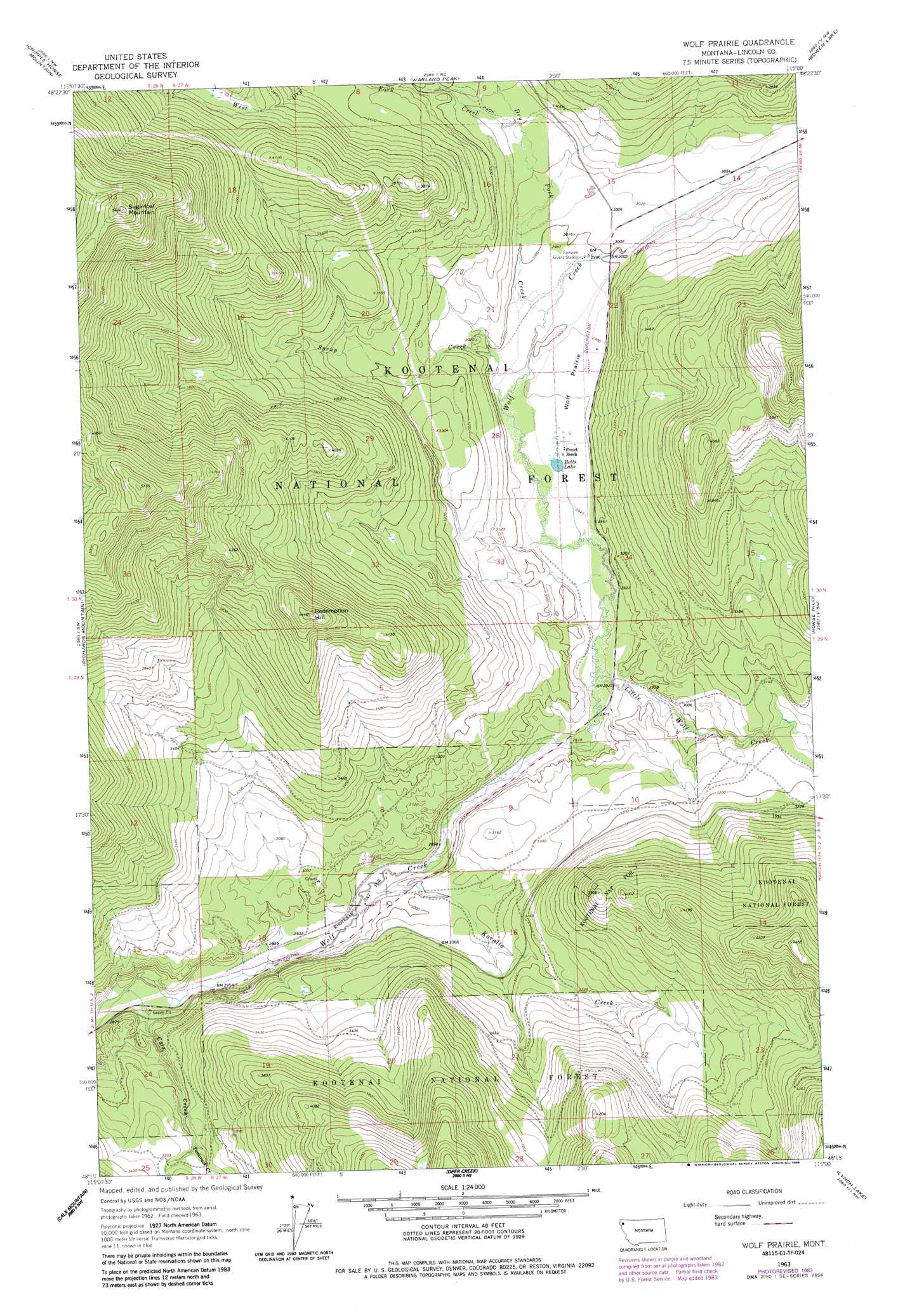
USGS Topo Quad 48115c1 - 1:24,000 scale
| Topo Map Name: | Wolf Prairie |
| USGS Topo Quad ID: | 48115c1 |
| Print Size: | ca. 21 1/4" wide x 27" high |
| Southeast Coordinates: | 48.25° N latitude / 115° W longitude |
| Map Center Coordinates: | 48.3125° N latitude / 115.0625° W longitude |
| U.S. State: | MT |
| Filename: | o48115c1.jpg |
| Download Map JPG Image: | Wolf Prairie topo map 1:24,000 scale |
| Map Type: | Topographic |
| Topo Series: | 7.5´ |
| Map Scale: | 1:24,000 |
| Source of Map Images: | United States Geological Survey (USGS) |
| Alternate Map Versions: |
Wolf Prairie MT 1963, updated 1965 Download PDF Buy paper map Wolf Prairie MT 1963, updated 1984 Download PDF Buy paper map Wolf Prairie MT 1997, updated 2000 Download PDF Buy paper map Wolf Prairie MT 2011 Download PDF Buy paper map Wolf Prairie MT 2014 Download PDF Buy paper map |
| FStopo: | US Forest Service topo Wolf Prairie is available: Download FStopo PDF Download FStopo TIF |
1:24,000 Topo Quads surrounding Wolf Prairie
Ural |
Volcour |
Davis Mountain |
Skillet Mountain |
Sunday Mountain |
Alexander Mountain |
Cripple Horse Mountain |
Warland Peak |
Bowen Lake |
Dunsire Point |
Tony Peak |
Richards Mountain |
Wolf Prairie |
Horse Hill |
Sylvia Lake |
Fisher Mountain |
Calx Mountain |
Deer Creek |
Lynch Lake |
Dahl Lake |
Kenelty Mountain |
Loon Lake |
Thompson Lakes |
Meadow Peak |
Mcgregor Peak |
> Back to 48115a1 at 1:100,000 scale
> Back to 48114a1 at 1:250,000 scale
> Back to U.S. Topo Maps home
Wolf Prairie topo map: Gazetteer
Wolf Prairie: Flats
Wolf Prairie elevation 905m 2969′Wolf Prairie: Lakes
Betts Lake elevation 899m 2949′Wolf Prairie: Mines
Strad Beck Mine elevation 1086m 3562′Wolf Prairie: Post Offices
Atlanta Post Office (historical) elevation 967m 3172′Wolf Prairie: Streams
Calx Creek elevation 866m 2841′Dry Fork Creek elevation 906m 2972′
Kavalla Creek elevation 879m 2883′
Little Wolf Creek elevation 887m 2910′
Syrup Creek elevation 901m 2956′
Tamarack Creek elevation 989m 3244′
West Dry Fork Creek elevation 929m 3047′
Wolf Prairie: Summits
Redemption Hill elevation 1358m 4455′Sugarloaf Mountain elevation 1650m 5413′
Wolf Prairie digital topo map on disk
Buy this Wolf Prairie topo map showing relief, roads, GPS coordinates and other geographical features, as a high-resolution digital map file on DVD: