Wellington Peak Topo Map Washington
To zoom in, hover over the map of Wellington Peak
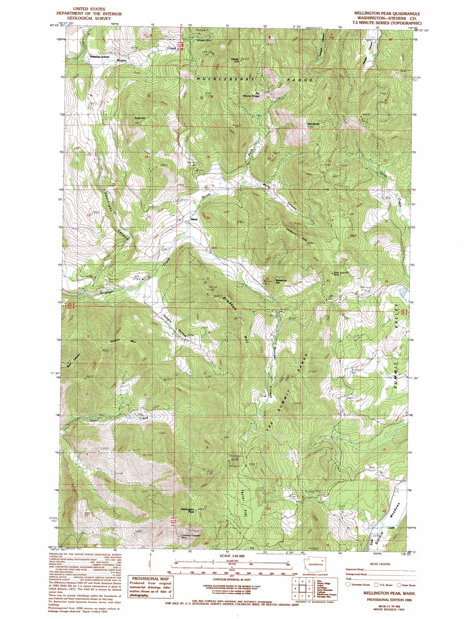
USGS Topo Quad 48118c1 - 1:24,000 scale
| Topo Map Name: | Wellington Peak |
| USGS Topo Quad ID: | 48118c1 |
| Print Size: | ca. 21 1/4" wide x 27" high |
| Southeast Coordinates: | 48.25° N latitude / 118° W longitude |
| Map Center Coordinates: | 48.3125° N latitude / 118.0625° W longitude |
| U.S. State: | WA |
| Filename: | o48118c1.jpg |
| Download Map JPG Image: | Wellington Peak topo map 1:24,000 scale |
| Map Type: | Topographic |
| Topo Series: | 7.5´ |
| Map Scale: | 1:24,000 |
| Source of Map Images: | United States Geological Survey (USGS) |
| Alternate Map Versions: |
Wellington Peak WA 1985, updated 1985 Download PDF Buy paper map Wellington Peak WA 1985, updated 1993 Download PDF Buy paper map Wellington Peak WA 2011 Download PDF Buy paper map Wellington Peak WA 2014 Download PDF Buy paper map |
1:24,000 Topo Quads surrounding Wellington Peak
South Huckleberry Mountain |
Bangs Mountain |
Kettle Falls |
Colville |
White Mud Lake |
La Fleur Lake |
Rice |
Kentry Ridge |
Arden |
Addy Mountain |
Moon Mountain |
Inchelium |
Wellington Peak |
Dunn Mountain |
Addy |
Kewa |
Cedonia |
Blackhorse Canyon |
Stensgar Mountain |
Waitts Lake |
Miller Mountain |
Hunters |
Adams Mountain |
Empey Mountain |
Forest Center |
> Back to 48118a1 at 1:100,000 scale
> Back to 48118a1 at 1:250,000 scale
> Back to U.S. Topo Maps home
Wellington Peak topo map: Gazetteer
Wellington Peak: Arches
The Natural Bridge elevation 1182m 3877′Wellington Peak: Basins
Summit Valley elevation 845m 2772′Wellington Peak: Flats
Goose Heaven elevation 713m 2339′Schmid Meadows elevation 807m 2647′
Taylor Flat elevation 1125m 3690′
Wellington Peak: Mines
Columbia Tungsten Mine elevation 1068m 3503′Silver Summit Mine elevation 1087m 3566′
Tempest Mine elevation 931m 3054′
Wellington Peak: Populated Places
Maud elevation 734m 2408′Waterloo elevation 715m 2345′
Wellington Peak: Ranges
The Summit Range elevation 1148m 3766′Wellington Peak: Streams
North Fork Stranger Creek elevation 694m 2276′Wellington Peak: Summits
Bradeen Hill elevation 1114m 3654′Buttercup Hill elevation 1001m 3284′
Colburn Hill elevation 1239m 4064′
Gold Hill elevation 1110m 3641′
Keedy Hill elevation 1343m 4406′
Old Baldy elevation 1382m 4534′
Quartz Mountain elevation 1065m 3494′
Wellington Peak elevation 1362m 4468′
Wellington Peak: Valleys
Burnt Canyon elevation 811m 2660′Courtright Canyon elevation 690m 2263′
Hungry Hollow elevation 640m 2099′
Wellington Peak digital topo map on disk
Buy this Wellington Peak topo map showing relief, roads, GPS coordinates and other geographical features, as a high-resolution digital map file on DVD: