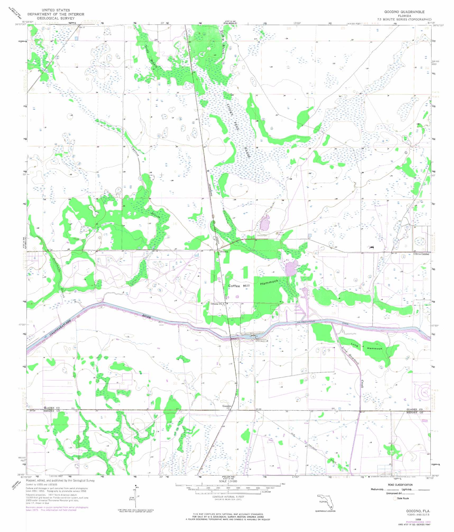
Goodno Topo Map Florida
To zoom in, hover over the map of Goodno
USGS Topo Quad 26081g3 - 1:24,000 scale
| Topo Map Name: | Goodno |
| USGS Topo Quad ID: | 26081g3 |
| Print Size: | ca. 21 1/4" wide x 27" high |
| Southeast Coordinates: | 26.75° N latitude / 81.25° W longitude |
| Map Center Coordinates: | 26.8125° N latitude / 81.3125° W longitude |
| U.S. State: | FL |
| Filename: | O26081G3.jpg |
| Download Map JPG Image: | Goodno topo map 1:24,000 scale |
| Map Type: | Topographic |
| Topo Series: | 7.5´ |
| Map Scale: | 1:24,000 |
| Source of Map Images: | United States Geological Survey (USGS) |
| Alternate Map Versions: |
Goodno FL 1958, updated 1959 Download PDF Buy paper map Goodno FL 1958, updated 1974 Download PDF Buy paper map Goodno FL 2012 Download PDF Buy paper map Goodno FL 2015 Download PDF Buy paper map |
1:24,000 Topo Quads surrounding Goodno
Long Island Marsh Se |
Venus Sw |
Venus |
Brighton Sw |
Brighton Se |
Telegraph Swamp Ne |
La Belle Nw |
Palmdale |
Lakeport |
Fisheating Bay |
Telegraph Swamp Se |
La Belle |
Goodno |
Lake Hicpochee |
Moore Haven |
Alva |
Sears |
Felda Ne |
La Belle 4 Nw |
La Belle 4 Ne |
Alva Se |
Felda |
Felda Se |
La Belle 4 Sw |
La Belle 4 Se |
> Back to 26081e1 at 1:100,000 scale
> Back to 26080a1 at 1:250,000 scale
> Back to U.S. Topo Maps home
Goodno topo map: Gazetteer
Goodno: Canals
Caloosahatchee Canal elevation 3m 9′Goodno: Dams
Ortona Lock elevation 4m 13′Goodno: Islands
Coffee Mill Hammock elevation 6m 19′Long Hammock elevation 4m 13′
Goodno: Lakes
W H Peeples Pond Three elevation 9m 29′W H Peeples Pond Two elevation 6m 19′
Goodno: Mines
Caloosahatchee Rock Mine elevation 7m 22′Goodno: Populated Places
Goodno elevation 5m 16′Ortona elevation 7m 22′
Goodno: Streams
Chaparral Slough elevation 10m 32′Cypress Branch elevation 1m 3′
Deadmans Branch elevation 1m 3′
Long Hammock Creek elevation 3m 9′
Turkey Branch elevation 9m 29′
York Branch elevation 9m 29′
Goodno: Swamps
Linden Pens Marsh elevation 9m 29′Goodno digital topo map on disk
Buy this Goodno topo map showing relief, roads, GPS coordinates and other geographical features, as a high-resolution digital map file on DVD: