Inverness Topo Map Florida
To zoom in, hover over the map of Inverness
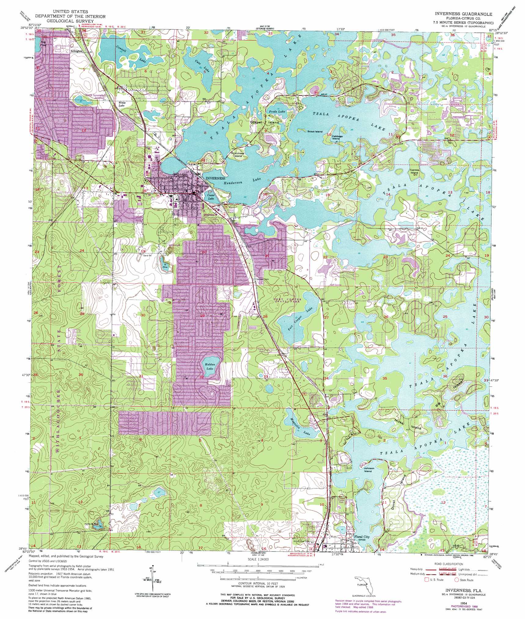
USGS Topo Quad 28082g3 - 1:24,000 scale
| Topo Map Name: | Inverness |
| USGS Topo Quad ID: | 28082g3 |
| Print Size: | ca. 21 1/4" wide x 27" high |
| Southeast Coordinates: | 28.75° N latitude / 82.25° W longitude |
| Map Center Coordinates: | 28.8125° N latitude / 82.3125° W longitude |
| U.S. State: | FL |
| Filename: | O28082G3.jpg |
| Download Map JPG Image: | Inverness topo map 1:24,000 scale |
| Map Type: | Topographic |
| Topo Series: | 7.5´ |
| Map Scale: | 1:24,000 |
| Source of Map Images: | United States Geological Survey (USGS) |
| Alternate Map Versions: |
Inverness FL 1954, updated 1955 Download PDF Buy paper map Inverness FL 1954, updated 1965 Download PDF Buy paper map Inverness FL 1954, updated 1988 Download PDF Buy paper map Inverness FL 1954, updated 1988 Download PDF Buy paper map Inverness FL 2012 Download PDF Buy paper map Inverness FL 2015 Download PDF Buy paper map |
1:24,000 Topo Quads surrounding Inverness
Yankeetown Se |
Dunnellon |
Dunnellon Se |
Shady |
Belleview |
Crystal River |
Holder |
Stokes Ferry |
Lake Panasoffkee Nw |
Oxford |
Homosassa |
Lecanto |
Inverness |
Rutland |
Wildwood |
Chassahowitzka |
Brooksville Nw |
Nobelton |
Wahoo |
Bushnell |
Weeki Wachee Spring |
Brooksville |
Brooksville Se |
Saint Catherine |
Webster |
> Back to 28082e1 at 1:100,000 scale
> Back to 28082a1 at 1:250,000 scale
> Back to U.S. Topo Maps home
Inverness topo map: Gazetteer
Inverness: Airports
Citrus County Sheriff's Office Heliport elevation 13m 42′Inverness Airport elevation 14m 45′
Ringhaver Heliport elevation 24m 78′
Inverness: Islands
Big Island elevation 12m 39′Cabbage Island elevation 12m 39′
Cypress Island elevation 13m 42′
Duval Island elevation 19m 62′
Gospel Island elevation 15m 49′
Hicks Island elevation 14m 45′
Johnson Island elevation 16m 52′
Pritchard Island elevation 16m 52′
Scout Island elevation 12m 39′
Inverness: Lakes
Cato Lake elevation 12m 39′Connell Lake elevation 10m 32′
Cooter Lake elevation 13m 42′
Fort Cooper Lake elevation 9m 29′
Freds Lake elevation 12m 39′
Henderson Lake elevation 12m 39′
Holden Lake elevation 10m 32′
Magnolia Lake elevation 9m 29′
White Lake elevation 13m 42′
Inverness: Mines
Hamburg Mine elevation 4m 13′Inverness: Parks
Fort Cooper State Park elevation 15m 49′Wallace Brooks Park elevation 13m 42′
Inverness: Populated Places
Arlington elevation 16m 52′Inverness elevation 15m 49′
Inverness: Post Offices
Floral City Post Office elevation 19m 62′Inverness US Post Office elevation 24m 78′
Inverness digital topo map on disk
Buy this Inverness topo map showing relief, roads, GPS coordinates and other geographical features, as a high-resolution digital map file on DVD: