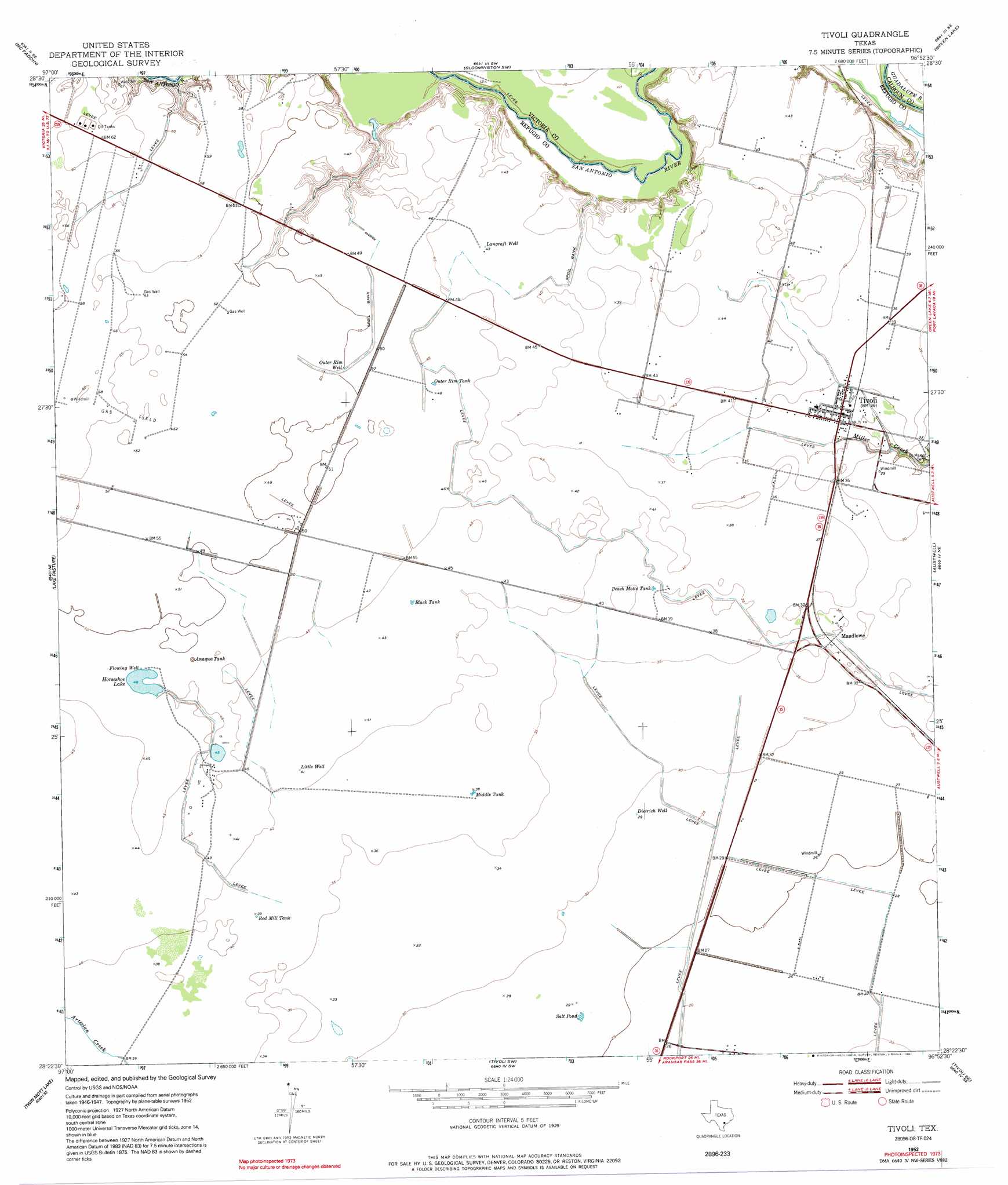
Tivoli Topo Map Texas
To zoom in, hover over the map of Tivoli
USGS Topo Quad 28096d8 - 1:24,000 scale
| Topo Map Name: | Tivoli |
| USGS Topo Quad ID: | 28096d8 |
| Print Size: | ca. 21 1/4" wide x 27" high |
| Southeast Coordinates: | 28.375° N latitude / 96.875° W longitude |
| Map Center Coordinates: | 28.4375° N latitude / 96.9375° W longitude |
| U.S. State: | TX |
| Filename: | o28096d8.jpg |
| Download Map JPG Image: | Tivoli topo map 1:24,000 scale |
| Map Type: | Topographic |
| Topo Series: | 7.5´ |
| Map Scale: | 1:24,000 |
| Source of Map Images: | United States Geological Survey (USGS) |
| Alternate Map Versions: |
Tivoli TX 1952, updated 1953 Download PDF Buy paper map Tivoli TX 1952, updated 1974 Download PDF Buy paper map Tivoli TX 1952, updated 1991 Download PDF Buy paper map Tivoli TX 2010 Download PDF Buy paper map Tivoli TX 2013 Download PDF Buy paper map Tivoli TX 2016 Download PDF Buy paper map |
1:24,000 Topo Quads surrounding Tivoli
Fannin |
Raisin |
Bloomington |
Placedo |
Kamey |
Lott Lake |
Mcfaddin |
Bloomington Sw |
Green Lake |
Port Lavaca West |
Vidaurri |
Lake Pasture |
Tivoli |
Austwell |
Seadrift |
Quintana |
Twin Mott Lake |
Tivoli Sw |
Tivoli Se |
Mosquito Point |
Mission Bay |
Lamar |
Saint Charles Bay |
Mesquite Bay |
Panther Point |
> Back to 28096a1 at 1:100,000 scale
> Back to 28096a1 at 1:250,000 scale
> Back to U.S. Topo Maps home
Tivoli topo map: Gazetteer
Tivoli: Lakes
Horseshoe Lake elevation 14m 45′Salt Pond elevation 8m 26′
Tivoli: Populated Places
Maudlowe elevation 10m 32′Tivoli elevation 9m 29′
Tivoli: Reservoirs
Anaqua Tank elevation 14m 45′Black Tank elevation 13m 42′
Middle Tank elevation 11m 36′
Outer Rim Tank elevation 14m 45′
Peach Motte Tank elevation 11m 36′
Red Mill Tank elevation 12m 39′
Tivoli: Wells
Dietrich Well elevation 9m 29′Langraft Well elevation 13m 42′
Little Well elevation 12m 39′
Outer Rim Well elevation 15m 49′
Tivoli digital topo map on disk
Buy this Tivoli topo map showing relief, roads, GPS coordinates and other geographical features, as a high-resolution digital map file on DVD: