North Of Allanton Topo Map Florida
To zoom in, hover over the map of North Of Allanton
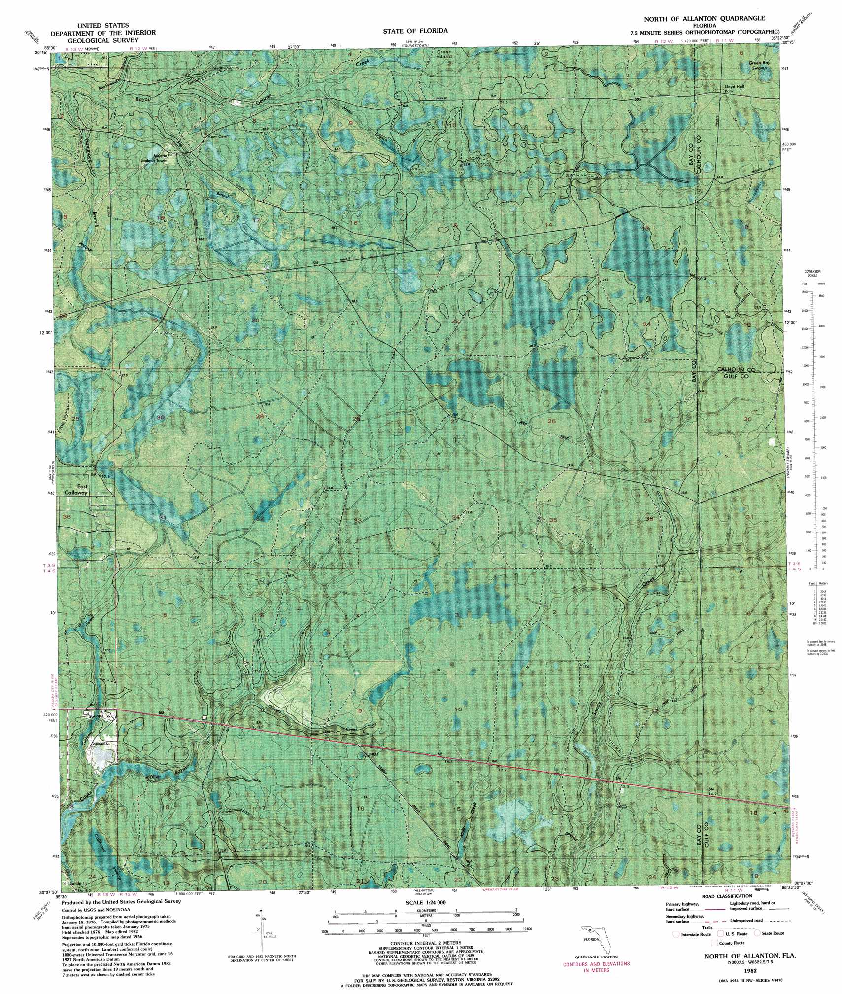
USGS Topo Quad 30085b4 - 1:24,000 scale
| Topo Map Name: | North Of Allanton |
| USGS Topo Quad ID: | 30085b4 |
| Print Size: | ca. 21 1/4" wide x 27" high |
| Southeast Coordinates: | 30.125° N latitude / 85.375° W longitude |
| Map Center Coordinates: | 30.1875° N latitude / 85.4375° W longitude |
| U.S. State: | FL |
| Filename: | P30085b4.jpg |
| Download Map JPG Image: | North Of Allanton topo map 1:24,000 scale |
| Map Type: | Orthophoto |
| Topo Series: | 7.5´ |
| Map Scale: | 1:24,000 |
| Source of Map Images: | United States Geological Survey (USGS) |
| Alternate Map Versions: |
North Of Allanton FL 1956, updated 1957 Download PDF Buy paper map North Of Allanton FL 1982, updated 1983 Download PDF Buy paper map North of Allanton FL 2012 Download PDF Buy paper map North of Allanton FL 2015 Download PDF Buy paper map |
1:24,000 Topo Quads surrounding North Of Allanton
Crystal Lake |
Bennett |
Fountain |
Juniper Creek |
Clarksville |
Southport |
Bayhead |
Youngstown |
Broad Branch |
Frink |
Panama City |
Springfield |
North Of Allanton |
Tenmile Swamp |
Dead Lake |
Beacon Beach |
Long Point |
Allanton |
Wetappo Creek |
Wewahitchka |
Crooked Island |
Beacon Hill |
Overstreet |
White City |
> Back to 30085a1 at 1:100,000 scale
> Back to 30084a1 at 1:250,000 scale
> Back to U.S. Topo Maps home
North Of Allanton topo map: Gazetteer
North Of Allanton: Islands
Crash Island elevation 18m 59′North Of Allanton: Parks
Lloyd Hall Park elevation 23m 75′North Of Allanton: Streams
Beefwood Branch elevation 5m 16′Big Branch elevation 7m 22′
Cushion Creek elevation 0m 0′
Hammock Branch elevation 5m 16′
Horseford Branch elevation 16m 52′
Island Branch elevation 9m 29′
Olivers Creek elevation 6m 19′
Water Branch elevation 14m 45′
White Buck Branch elevation 6m 19′
North Of Allanton digital topo map on disk
Buy this North Of Allanton topo map showing relief, roads, GPS coordinates and other geographical features, as a high-resolution digital map file on DVD:
Gulf Coast (LA, MS, AL, FL) & Southwestern Georgia
Buy digital topo maps: Gulf Coast (LA, MS, AL, FL) & Southwestern Georgia
 & Southwestern Georgia map DVD")