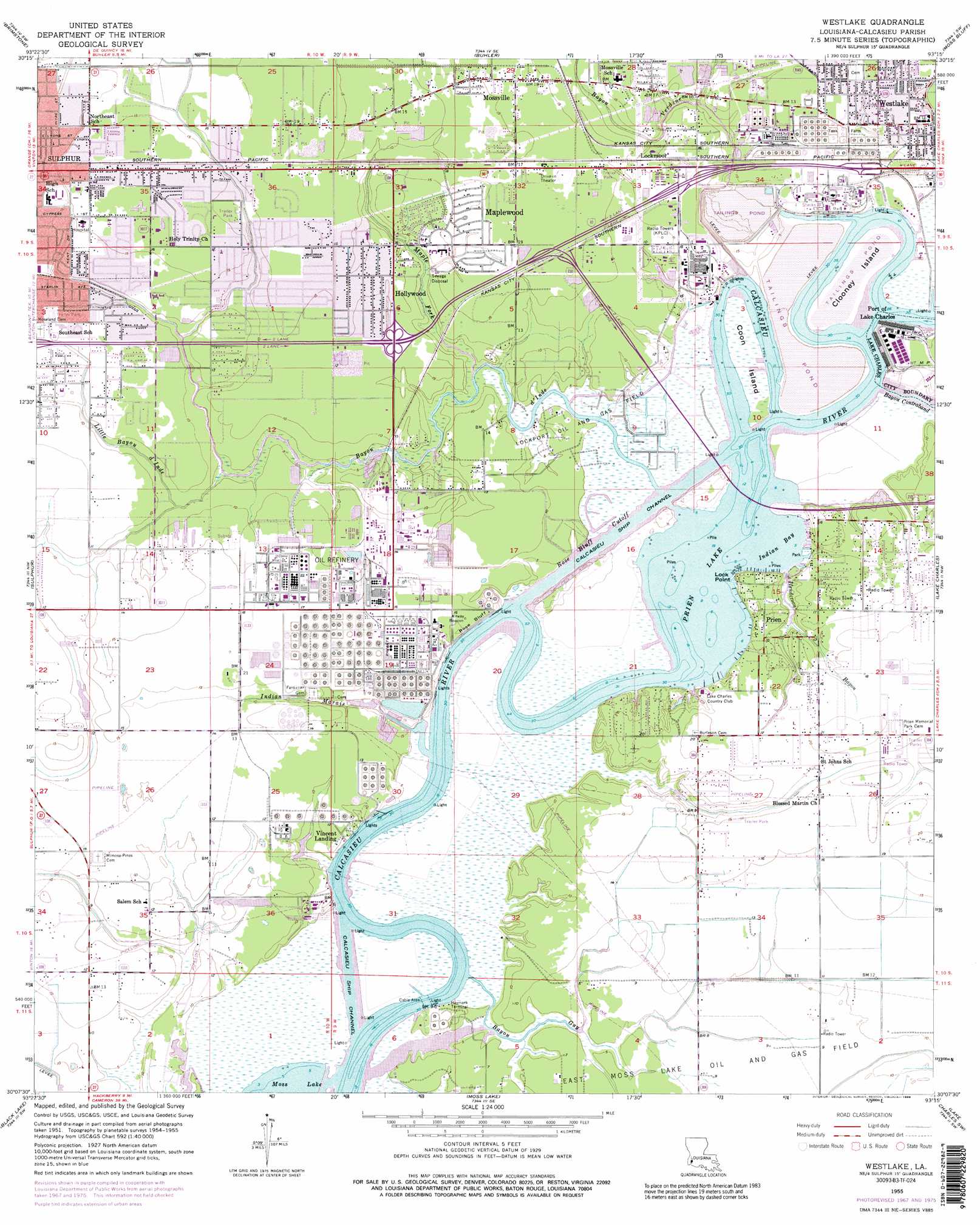
Westlake Topo Map Louisiana
To zoom in, hover over the map of Westlake
USGS Topo Quad 30093b3 - 1:24,000 scale
| Topo Map Name: | Westlake |
| USGS Topo Quad ID: | 30093b3 |
| Print Size: | ca. 21 1/4" wide x 27" high |
| Southeast Coordinates: | 30.125° N latitude / 93.25° W longitude |
| Map Center Coordinates: | 30.1875° N latitude / 93.3125° W longitude |
| U.S. State: | LA |
| Filename: | o30093b3.jpg |
| Download Map JPG Image: | Westlake topo map 1:24,000 scale |
| Map Type: | Topographic |
| Topo Series: | 7.5´ |
| Map Scale: | 1:24,000 |
| Source of Map Images: | United States Geological Survey (USGS) |
| Alternate Map Versions: |
Westlake LA 1955, updated 1956 Download PDF Buy paper map Westlake LA 1955, updated 1968 Download PDF Buy paper map Westlake LA 1955, updated 1976 Download PDF Buy paper map Westlake LA 1955, updated 1989 Download PDF Buy paper map Westlake LA 1994, updated 1996 Download PDF Buy paper map Westlake LA 1996, updated 1999 Download PDF Buy paper map Westlake LA 2012 Download PDF Buy paper map Westlake LA 2015 Download PDF Buy paper map |
1:24,000 Topo Quads surrounding Westlake
Clark Hollow |
De Quincy |
Gordon |
Gaytine |
Topsy |
Lunita |
Brimstone |
Buhler |
Moss Bluff |
Hecker |
Vinton |
Sulphur |
Westlake |
Lake Charles |
Iowa |
Cameron Farms |
Black Lake |
Moss Lake |
Lake Charles Sw |
Lake Charles Se |
Five Lakes |
Browns Lake |
Hackberry |
Sweet Lake |
Boudreaux Lake |
> Back to 30093a1 at 1:100,000 scale
> Back to 30092a1 at 1:250,000 scale
> Back to U.S. Topo Maps home
Westlake topo map: Gazetteer
Westlake: Airports
All-Phase Heliport elevation 4m 13′Humana Hospital Heliport elevation 4m 13′
West Calcasieu Cameron Hospital Heliport elevation 4m 13′
Westlake: Bays
Indian Bay elevation 0m 0′Westlake: Bends
Rose Bluff Cutoff elevation 0m 0′Westlake: Capes
Lock Point elevation 1m 3′Westlake: Cliffs
Rose Bluff elevation 0m 0′Westlake: Crossings
Interchange 1 elevation 6m 19′Interchange 21 elevation 4m 13′
Interchange 23 elevation 5m 16′
Interchange 25 elevation 6m 19′
Interchange 26 elevation 4m 13′
Interchange 27 elevation 4m 13′
Westlake: Dams
Louisiana Noname 110 Dam elevation 7m 22′Westlake: Islands
Clooney Island elevation 3m 9′Coon Island elevation 0m 0′
Westlake: Lakes
Prien Lake elevation 0m 0′Westlake: Oilfields
East Moss Lake Oil and Gas Field elevation 2m 6′Lockport Oil and Gas Field elevation 0m 0′
Westlake: Parks
Center Circle Recreation Center elevation 4m 13′Interstate 210 Park elevation 2m 6′
Prien Lake Park elevation 3m 9′
Westlake Recreation Center elevation 4m 13′
Westlake: Populated Places
Hollywood elevation 4m 13′Lockmoor elevation 5m 16′
Maplewood elevation 5m 16′
Mossville elevation 6m 19′
Prien elevation 4m 13′
Rose Bluff elevation 6m 19′
Vincent Landing elevation 2m 6′
Westlake elevation 5m 16′
Westlake: Post Offices
Westlake Post Office elevation 4m 13′Westlake: Streams
Bayou Contraband elevation 0m 0′Bayou d'Inde elevation 0m 0′
Bayou Guy elevation 0m 0′
Bayou Verdine elevation 0m 0′
Henderson Bayou elevation 2m 6′
Indian Marais elevation 0m 0′
Little Bayou d'Inde elevation 2m 6′
Maple Fork elevation 0m 0′
Westlake digital topo map on disk
Buy this Westlake topo map showing relief, roads, GPS coordinates and other geographical features, as a high-resolution digital map file on DVD: