Dugout Mountain Topo Map Texas
To zoom in, hover over the map of Dugout Mountain
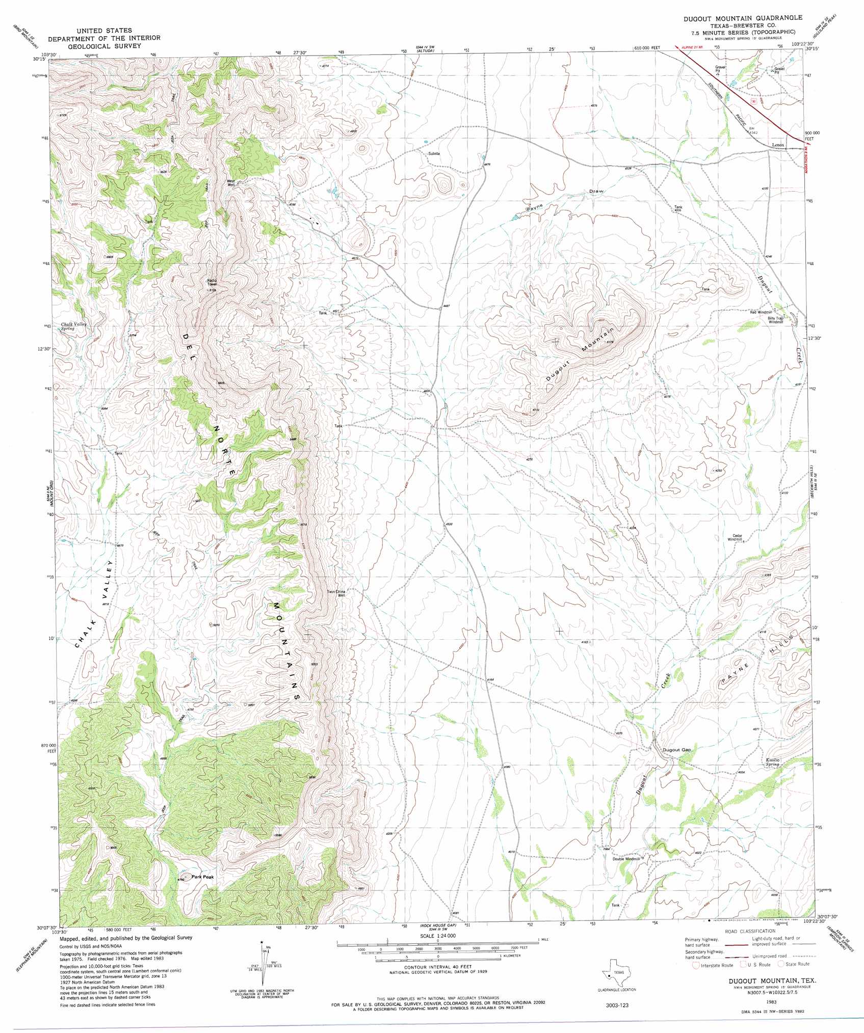
USGS Topo Quad 30103b4 - 1:24,000 scale
| Topo Map Name: | Dugout Mountain |
| USGS Topo Quad ID: | 30103b4 |
| Print Size: | ca. 21 1/4" wide x 27" high |
| Southeast Coordinates: | 30.125° N latitude / 103.375° W longitude |
| Map Center Coordinates: | 30.1875° N latitude / 103.4375° W longitude |
| U.S. State: | TX |
| Filename: | o30103b4.jpg |
| Download Map JPG Image: | Dugout Mountain topo map 1:24,000 scale |
| Map Type: | Topographic |
| Topo Series: | 7.5´ |
| Map Scale: | 1:24,000 |
| Source of Map Images: | United States Geological Survey (USGS) |
| Alternate Map Versions: |
Dugout Mountain TX 1983, updated 1984 Download PDF Buy paper map Dugout Mountain TX 2010 Download PDF Buy paper map Dugout Mountain TX 2012 Download PDF Buy paper map Dugout Mountain TX 2016 Download PDF Buy paper map |
1:24,000 Topo Quads surrounding Dugout Mountain
Alpine North |
Elam Mountain |
Bissett Mountain |
Old Blue Mountain |
Hess Canyon |
Alpine South |
Bird Mountain |
Altuda |
Gilliland Peak |
Leonard Mountain |
Cathedral Mountain |
Mount Ord |
Dugout Mountain |
Beckwith Hills |
Marathon |
Goat Mountain |
Elephant Mountain |
Rock House Gap |
Simpson Springs Mountain |
Pena Blanca Mountains |
Duff Springs |
Whirlwind Spring |
Paso Del Norte |
Maravillas Gap |
Heart Mountain |
> Back to 30103a1 at 1:100,000 scale
> Back to 30102a1 at 1:250,000 scale
> Back to U.S. Topo Maps home
Dugout Mountain topo map: Gazetteer
Dugout Mountain: Gaps
Dugout Gap elevation 1226m 4022′Dugout Mountain: Populated Places
Lenox elevation 1323m 4340′Dugout Mountain: Ranges
Del Norte Mountains elevation 1865m 6118′Dugout Mountain: Springs
Chalk Valley Spring elevation 1596m 5236′Emilio Spring elevation 1240m 4068′
Dugout Mountain: Summits
Dugout Mountain elevation 1573m 5160′Park Peak elevation 1427m 4681′
Dugout Mountain: Valleys
Payne Draw elevation 1305m 4281′Dugout Mountain: Wells
Twin China Well elevation 1370m 4494′West Well elevation 1532m 5026′
Dugout Mountain digital topo map on disk
Buy this Dugout Mountain topo map showing relief, roads, GPS coordinates and other geographical features, as a high-resolution digital map file on DVD: