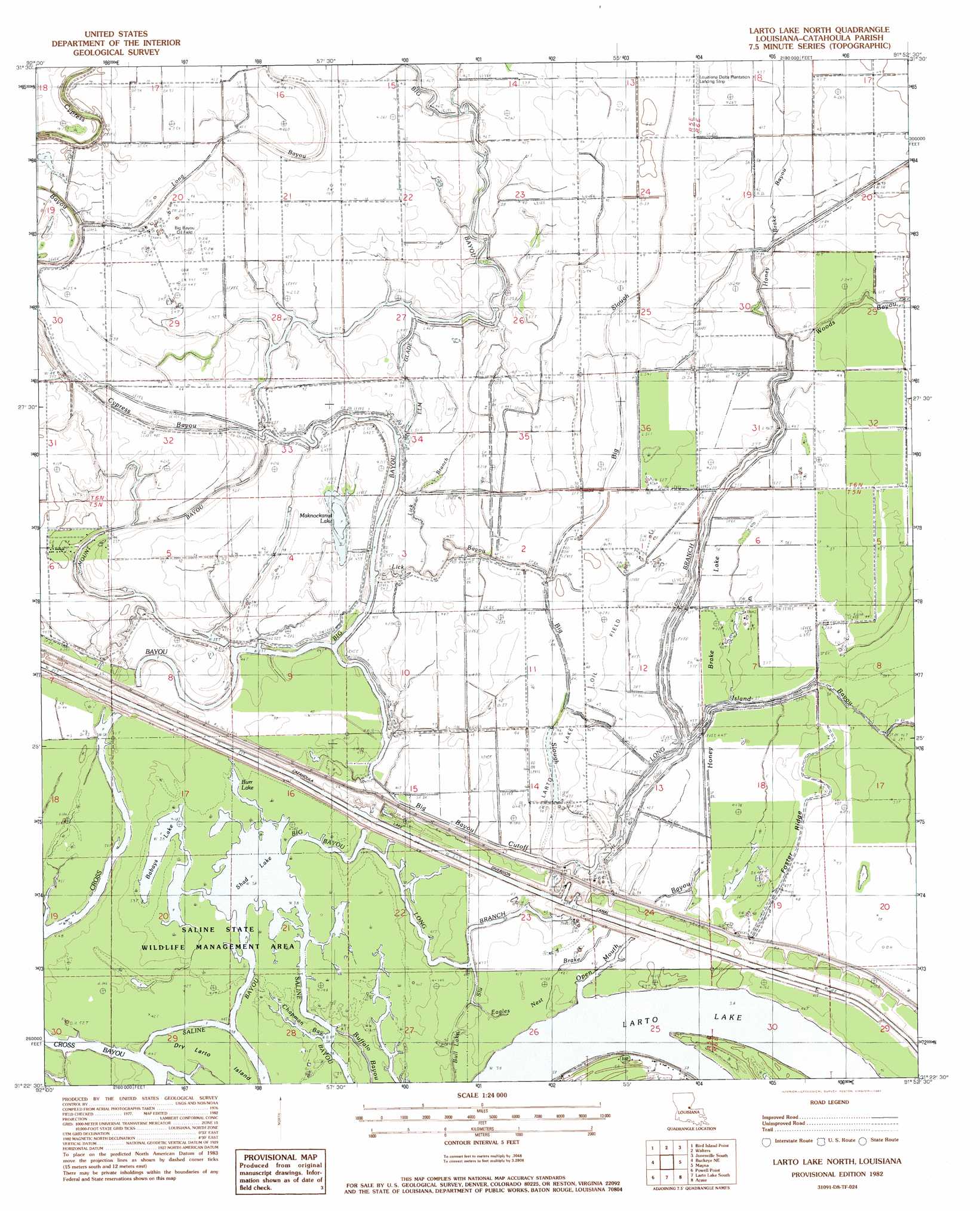
Larto Lake North Topo Map Louisiana
To zoom in, hover over the map of Larto Lake North
USGS Topo Quad 31091d8 - 1:24,000 scale
| Topo Map Name: | Larto Lake North |
| USGS Topo Quad ID: | 31091d8 |
| Print Size: | ca. 21 1/4" wide x 27" high |
| Southeast Coordinates: | 31.375° N latitude / 91.875° W longitude |
| Map Center Coordinates: | 31.4375° N latitude / 91.9375° W longitude |
| U.S. State: | LA |
| Filename: | o31091d8.jpg |
| Download Map JPG Image: | Larto Lake North topo map 1:24,000 scale |
| Map Type: | Topographic |
| Topo Series: | 7.5´ |
| Map Scale: | 1:24,000 |
| Source of Map Images: | United States Geological Survey (USGS) |
| Alternate Map Versions: |
Larto Lake North LA 1982, updated 1982 Download PDF Buy paper map Larto Lake North LA 1982, updated 1982 Download PDF Buy paper map Larto Lake North LA 2012 Download PDF Buy paper map Larto Lake North LA 2015 Download PDF Buy paper map |
1:24,000 Topo Quads surrounding Larto Lake North
Jena West |
Jena East |
Manifest |
Jonesville North |
Dunbarton |
Nebo |
Bird Island Point |
Walters |
Jonesville South |
Frogmore |
Holloway |
Buckeye Ne |
Larto Lake North |
Mayna |
Monterey |
Buckeye |
Powell Point |
Larto Lake South |
Acme |
Slocum |
Effie |
Marksville North |
Lac Sainte Agnes |
Ile Natchitoches |
Shaw |
> Back to 31091a1 at 1:100,000 scale
> Back to 31090a1 at 1:250,000 scale
> Back to U.S. Topo Maps home
Larto Lake North topo map: Gazetteer
Larto Lake North: Airports
Louisiana Delta Plantation Landing Strip elevation 14m 45′Larto Lake North: Channels
Big Bayou Cutoff elevation 9m 29′Larto Lake North: Islands
Dry Larto Island elevation 12m 39′Larto Lake North: Lakes
Babays Lake elevation 11m 36′Burr Lake elevation 11m 36′
Honey Brake Lake elevation 11m 36′
Larto Lake elevation 11m 36′
Maknockanut Lake elevation 10m 32′
Shad Lake elevation 11m 36′
Larto Lake North: Oilfields
Babays Lake Oil Field elevation 12m 39′Big Bayou Oil Field elevation 14m 45′
Cross Bayou Oil Field elevation 11m 36′
Foster Ridge Oil Field elevation 15m 49′
Honey Brake Lake Oil Field elevation 10m 32′
Larto Lake Oil Field elevation 14m 45′
Long Branch Oil Field elevation 14m 45′
North Long Branch Oil Field elevation 15m 49′
Serena Oil Field elevation 11m 36′
Larto Lake North: Ridges
Foster Ridge elevation 14m 45′Larto Lake North: Streams
Big Bayou elevation 11m 36′Big Slough elevation 11m 36′
Cypress Bayou elevation 10m 32′
Eagles Nest Brake elevation 13m 42′
Elm Glade elevation 10m 32′
Honey Brake Bayou elevation 10m 32′
Island Bayou elevation 12m 39′
Lick Bayou elevation 10m 32′
Lick Branch elevation 11m 36′
Long Branch elevation 11m 36′
Mount Bayou elevation 10m 32′
Open Mouth Bayou elevation 11m 36′
Woods Bayou elevation 10m 32′
Larto Lake North: Swamps
Chapman Bay elevation 12m 39′Gillespie Brake elevation 12m 39′
Hudson Brake elevation 10m 32′
Larto Lake North digital topo map on disk
Buy this Larto Lake North topo map showing relief, roads, GPS coordinates and other geographical features, as a high-resolution digital map file on DVD: