Rockland Topo Map Texas
To zoom in, hover over the map of Rockland
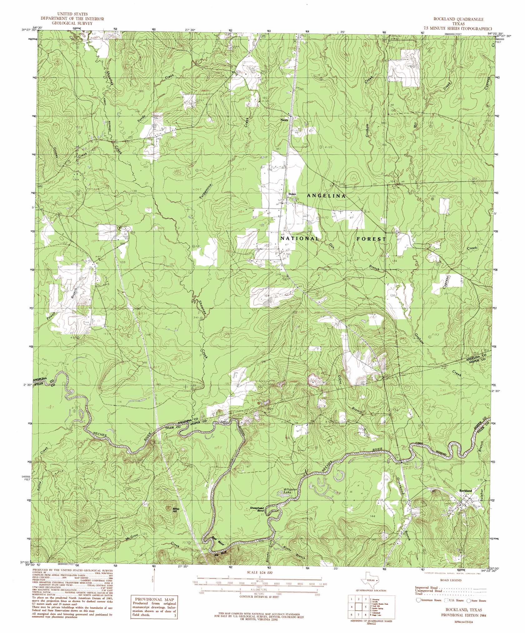
USGS Topo Quad 31094a4 - 1:24,000 scale
| Topo Map Name: | Rockland |
| USGS Topo Quad ID: | 31094a4 |
| Print Size: | ca. 21 1/4" wide x 27" high |
| Southeast Coordinates: | 31° N latitude / 94.375° W longitude |
| Map Center Coordinates: | 31.0625° N latitude / 94.4375° W longitude |
| U.S. State: | TX |
| Filename: | o31094a4.jpg |
| Download Map JPG Image: | Rockland topo map 1:24,000 scale |
| Map Type: | Topographic |
| Topo Series: | 7.5´ |
| Map Scale: | 1:24,000 |
| Source of Map Images: | United States Geological Survey (USGS) |
| Alternate Map Versions: |
Zavalla 3-c TX 1928 Download PDF Buy paper map Rockland TX 1984, updated 1984 Download PDF Buy paper map Rockland TX 2003, updated 2004 Download PDF Buy paper map Rockland TX 2010 Download PDF Buy paper map Rockland TX 2013 Download PDF Buy paper map Rockland TX 2016 Download PDF Buy paper map |
| FStopo: | US Forest Service topo Rockland is available: Download FStopo PDF Download FStopo TIF |
1:24,000 Topo Quads surrounding Rockland
Lufkin |
Huntington |
Etoile South |
Broaddus |
Harvey Creek |
Bald Hill |
Manning |
Zavalla |
Cassells-Boykin Park |
Veach |
Pluck |
Wolf Hill |
Rockland |
Boykin Spring |
Ebenezer |
Camden |
Chester |
Colmesneil |
Boggy Lake |
Pace Hill |
Hortense |
Chambliss Hill |
Woodville |
Birdwell Lake |
Town Bluff |
> Back to 31094a1 at 1:100,000 scale
> Back to 31094a1 at 1:250,000 scale
> Back to U.S. Topo Maps home
Rockland topo map: Gazetteer
Rockland: Bends
Best Bend elevation 32m 104′Sheephead Bend elevation 30m 98′
Rockland: Cliffs
Big Bluff elevation 53m 173′Rockland: Lakes
Alligator Lake elevation 32m 104′Rockland: Parks
Historic Monument of Fort Teran elevation 49m 160′Rockland: Populated Places
Dolan elevation 52m 170′Martin elevation 44m 144′
Nancy elevation 65m 213′
Rockland elevation 40m 131′
Rockland: Streams
Billiams Creek elevation 29m 95′Crane Branch elevation 29m 95′
Cypress Creek elevation 35m 114′
Greenwood Creek elevation 29m 95′
Grimes Creek elevation 41m 134′
Gum Branch elevation 36m 118′
McGraw Creek elevation 29m 95′
Mill Creek elevation 42m 137′
Oil Well Creek elevation 43m 141′
Rocky Hole Branch elevation 34m 111′
Russell Creek elevation 34m 111′
Saline Creek elevation 31m 101′
Sandy Creek elevation 45m 147′
Shawnee Creek elevation 31m 101′
Sulphur Branch elevation 34m 111′
Turpentine Creek elevation 38m 124′
Weeks Branch elevation 34m 111′
Rockland: Summits
Miles Hill elevation 62m 203′Rockland digital topo map on disk
Buy this Rockland topo map showing relief, roads, GPS coordinates and other geographical features, as a high-resolution digital map file on DVD: