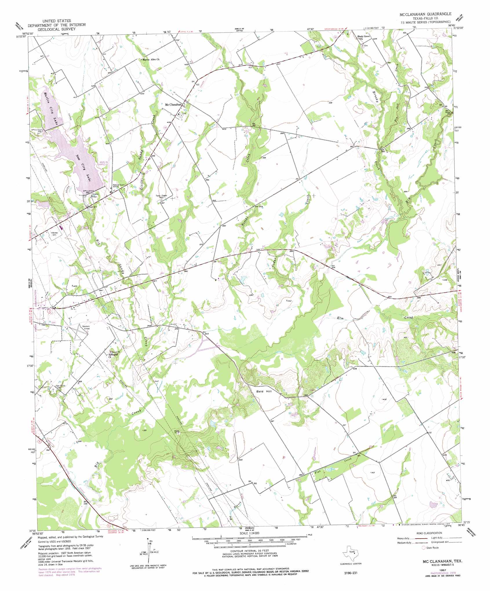
Mcclanahan Topo Map Texas
To zoom in, hover over the map of Mcclanahan
USGS Topo Quad 31096c7 - 1:24,000 scale
| Topo Map Name: | Mcclanahan |
| USGS Topo Quad ID: | 31096c7 |
| Print Size: | ca. 21 1/4" wide x 27" high |
| Southeast Coordinates: | 31.25° N latitude / 96.75° W longitude |
| Map Center Coordinates: | 31.3125° N latitude / 96.8125° W longitude |
| U.S. State: | TX |
| Filename: | o31096c7.jpg |
| Download Map JPG Image: | Mcclanahan topo map 1:24,000 scale |
| Map Type: | Topographic |
| Topo Series: | 7.5´ |
| Map Scale: | 1:24,000 |
| Source of Map Images: | United States Geological Survey (USGS) |
| Alternate Map Versions: |
McClanahan TX 1957, updated 1958 Download PDF Buy paper map McClanahan TX 1957, updated 1978 Download PDF Buy paper map McClanahan TX 2010 Download PDF Buy paper map McClanahan TX 2013 Download PDF Buy paper map McClanahan TX 2016 Download PDF Buy paper map |
1:24,000 Topo Quads surrounding Mcclanahan
Waco East |
Elk |
Mart |
Ben Hur |
Groesbeck |
Robinson |
Riesel |
Otto |
Odds |
Thornton |
Chilton |
Marlin |
Mcclanahan |
Kosse West |
Kosse East |
Lott |
Cedar Springs |
Reagan |
Bremond |
Petteway |
Westphalia |
Rosebud |
Baileyville |
Hammond |
Owensville |
> Back to 31096a1 at 1:100,000 scale
> Back to 31096a1 at 1:250,000 scale
> Back to U.S. Topo Maps home
Mcclanahan topo map: Gazetteer
Mcclanahan: Airports
Marlin Airport elevation 123m 403′Mcclanahan: Bridges
Bell Bridge elevation 110m 360′Mcclanahan: Dams
Marlin Old City Lake Dam elevation 123m 403′New Marlin Reservoir Dam elevation 116m 380′
Mcclanahan: Populated Places
McClanahan elevation 125m 410′Sunrise elevation 108m 354′
Mcclanahan: Reservoirs
City Lake elevation 116m 380′Marlin City Lake elevation 122m 400′
Marlin Old City Lake elevation 123m 403′
New City Lake elevation 117m 383′
Mcclanahan: Streams
Big Sandy Creek elevation 101m 331′Brushy Creek elevation 107m 351′
Cedar Creek elevation 103m 337′
Elm Creek elevation 104m 341′
Keechi Creek elevation 102m 334′
Little Sandy Creek elevation 105m 344′
Pin Oak Creek elevation 111m 364′
Mcclanahan: Summits
Bald Hill elevation 122m 400′Mcclanahan digital topo map on disk
Buy this Mcclanahan topo map showing relief, roads, GPS coordinates and other geographical features, as a high-resolution digital map file on DVD: