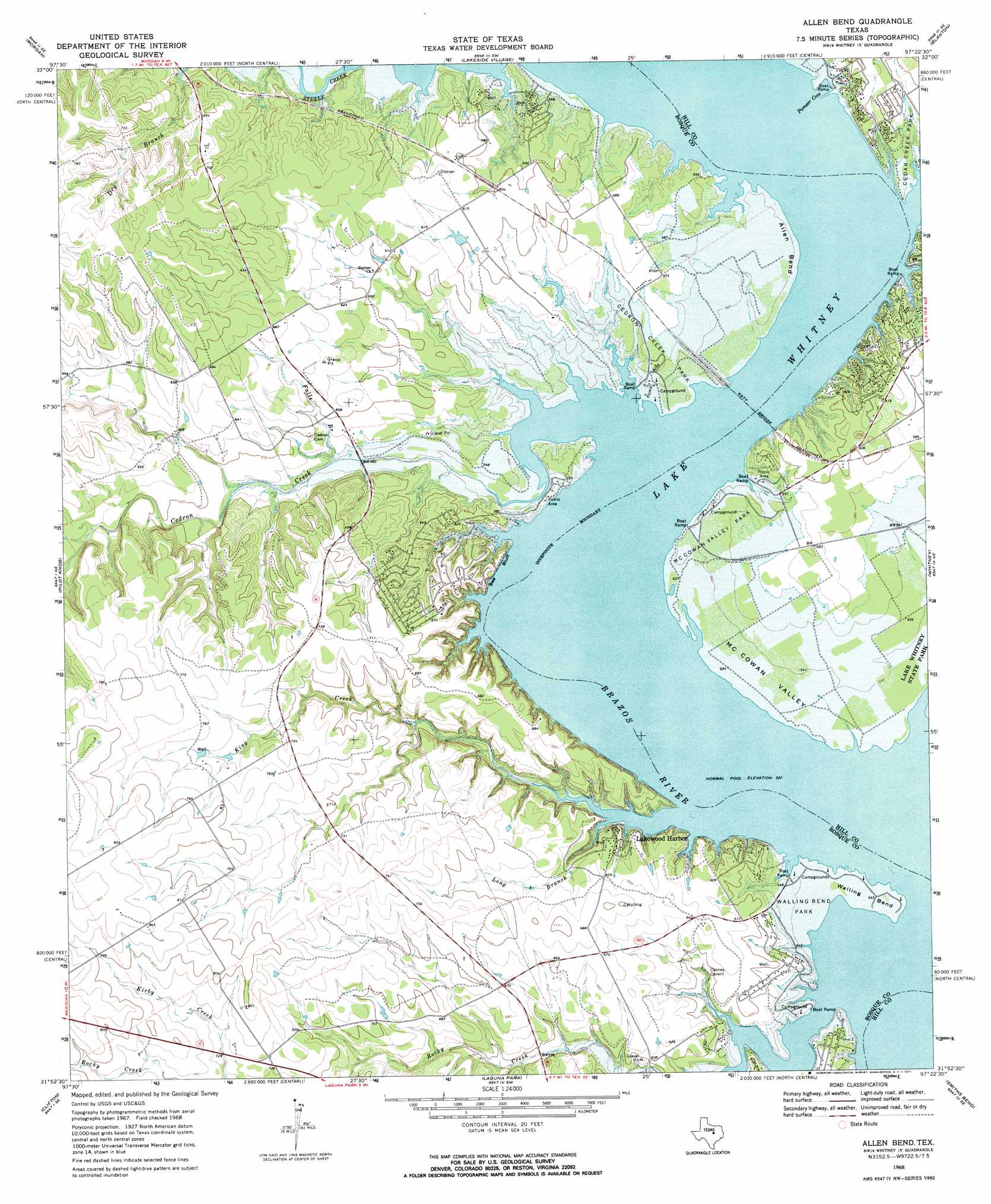
Allen Bend Topo Map Texas
To zoom in, hover over the map of Allen Bend
USGS Topo Quad 31097h4 - 1:24,000 scale
| Topo Map Name: | Allen Bend |
| USGS Topo Quad ID: | 31097h4 |
| Print Size: | ca. 21 1/4" wide x 27" high |
| Southeast Coordinates: | 31.875° N latitude / 97.375° W longitude |
| Map Center Coordinates: | 31.9375° N latitude / 97.4375° W longitude |
| U.S. State: | TX |
| Filename: | o31097h4.jpg |
| Download Map JPG Image: | Allen Bend topo map 1:24,000 scale |
| Map Type: | Topographic |
| Topo Series: | 7.5´ |
| Map Scale: | 1:24,000 |
| Source of Map Images: | United States Geological Survey (USGS) |
| Alternate Map Versions: |
Allen Bend TX 1968, updated 1971 Download PDF Buy paper map Allen Bend TX 2010 Download PDF Buy paper map Allen Bend TX 2012 Download PDF Buy paper map Allen Bend TX 2016 Download PDF Buy paper map |
1:24,000 Topo Quads surrounding Allen Bend
Glen Rose East |
Brazos Point |
Blum |
Covington |
Itasca |
Walnut Springs East |
Morgan |
Lakeside Village |
Blanton |
Hillsboro West |
Meridian |
Pilot Knob |
Allen Bend |
Whitney |
Peoria |
Sugarloaf Mountain |
Clifton |
Laguna Park |
Smiths Bend |
Aquilla |
Hurst Spring |
Mosheim |
Valley Mills |
China Springs |
Gholson |
> Back to 31097e1 at 1:100,000 scale
> Back to 31096a1 at 1:250,000 scale
> Back to U.S. Topo Maps home
Allen Bend topo map: Gazetteer
Allen Bend: Bays
Pioneer Cove elevation 159m 521′Allen Bend: Bends
Allen Bend elevation 165m 541′McCowan Valley elevation 164m 538′
Walling Bend elevation 165m 541′
Allen Bend: Bridges
Katy Bridge elevation 159m 521′Allen Bend: Cliffs
Bee Bluff elevation 175m 574′Allen Bend: Parks
McCown Valley Park elevation 170m 557′Allen Bend: Populated Places
Cedar Shores elevation 177m 580′Lakewood Harbor elevation 177m 580′
Allen Bend: Streams
Cedar Creek elevation 159m 521′Cedron Creek elevation 159m 521′
Falls Branch elevation 170m 557′
Frazier Creek elevation 159m 521′
King Creek elevation 159m 521′
Long Branch elevation 159m 521′
Rocky Creek elevation 159m 521′
Allen Bend digital topo map on disk
Buy this Allen Bend topo map showing relief, roads, GPS coordinates and other geographical features, as a high-resolution digital map file on DVD: