Whitney Topo Map Texas
To zoom in, hover over the map of Whitney
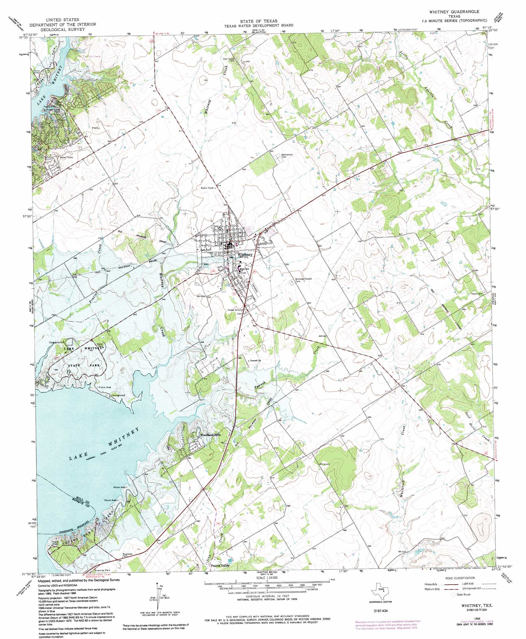
USGS Topo Quad 31097h3 - 1:24,000 scale
| Topo Map Name: | Whitney |
| USGS Topo Quad ID: | 31097h3 |
| Print Size: | ca. 21 1/4" wide x 27" high |
| Southeast Coordinates: | 31.875° N latitude / 97.25° W longitude |
| Map Center Coordinates: | 31.9375° N latitude / 97.3125° W longitude |
| U.S. State: | TX |
| Filename: | o31097h3.jpg |
| Download Map JPG Image: | Whitney topo map 1:24,000 scale |
| Map Type: | Topographic |
| Topo Series: | 7.5´ |
| Map Scale: | 1:24,000 |
| Source of Map Images: | United States Geological Survey (USGS) |
| Alternate Map Versions: |
Whitney TX 1966, updated 1969 Download PDF Buy paper map Whitney TX 1966, updated 1991 Download PDF Buy paper map Whitney TX 2010 Download PDF Buy paper map Whitney TX 2012 Download PDF Buy paper map Whitney TX 2016 Download PDF Buy paper map |
1:24,000 Topo Quads surrounding Whitney
Brazos Point |
Blum |
Covington |
Itasca |
Files Valley |
Morgan |
Lakeside Village |
Blanton |
Hillsboro West |
Hillsboro East |
Pilot Knob |
Allen Bend |
Whitney |
Peoria |
Abbott |
Clifton |
Laguna Park |
Smiths Bend |
Aquilla |
West |
Mosheim |
Valley Mills |
China Springs |
Gholson |
Elm Mott |
> Back to 31097e1 at 1:100,000 scale
> Back to 31096a1 at 1:250,000 scale
> Back to U.S. Topo Maps home
Whitney topo map: Gazetteer
Whitney: Airports
Lake Whitney State Park Airport elevation 170m 557′Whitney: Parks
Cedar Creek Park elevation 171m 561′Juniper Cove Park elevation 163m 534′
Lake Whitney State Park elevation 171m 561′
Lake Whitney State Park elevation 166m 544′
Lofers Bend Park elevation 170m 557′
Whitney: Populated Places
Prairie Valley elevation 162m 531′Whitney elevation 181m 593′
Woodland Hills elevation 177m 580′
Whitney: Streams
Towash Creek elevation 159m 521′Whitney Creek elevation 159m 521′
Whitney: Trails
Lake Whitney State Park Hiking Trail elevation 170m 557′Whitney digital topo map on disk
Buy this Whitney topo map showing relief, roads, GPS coordinates and other geographical features, as a high-resolution digital map file on DVD: