Mount Hughes Topo Map Arizona
To zoom in, hover over the map of Mount Hughes
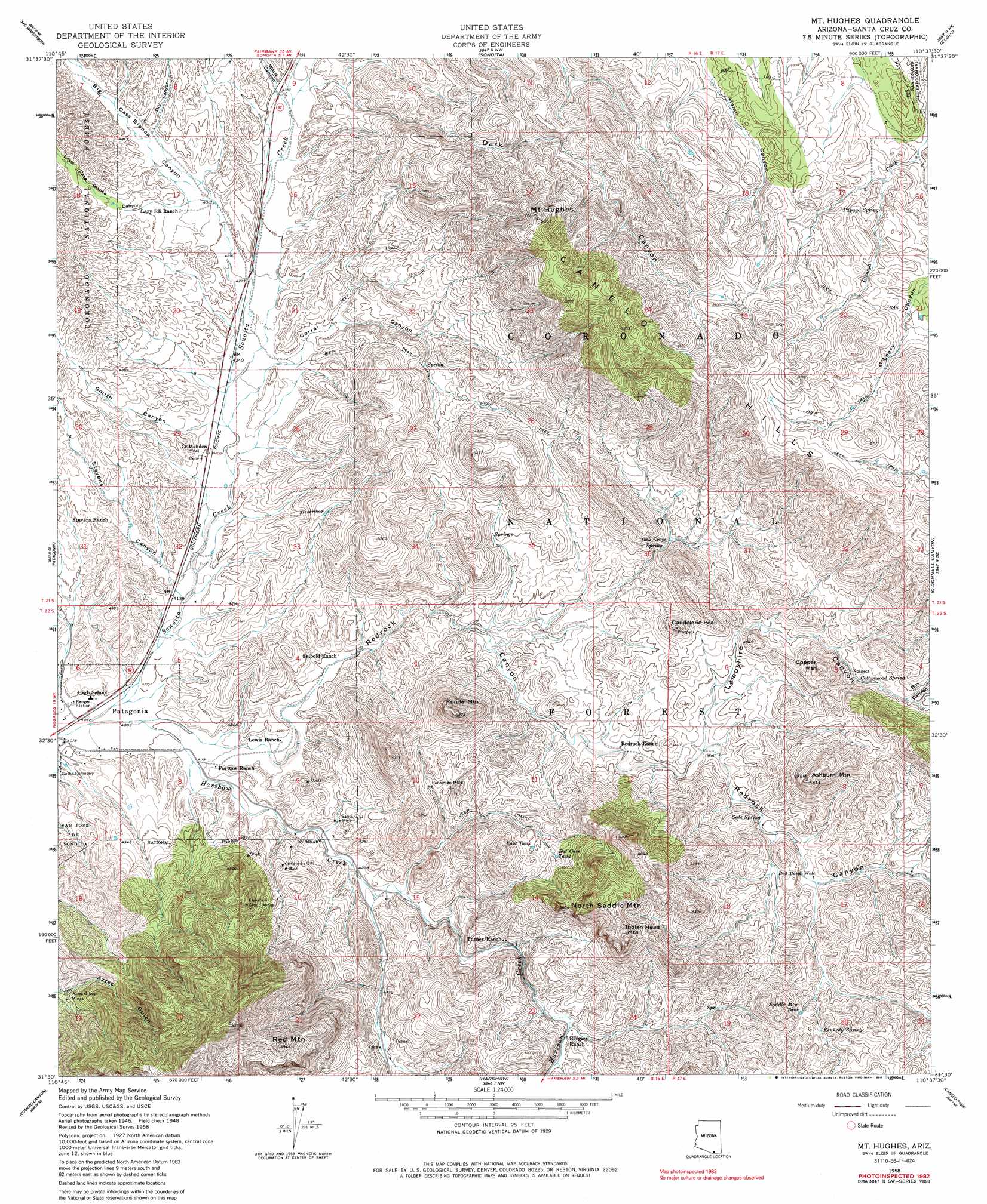
USGS Topo Quad 31110e6 - 1:24,000 scale
| Topo Map Name: | Mount Hughes |
| USGS Topo Quad ID: | 31110e6 |
| Print Size: | ca. 21 1/4" wide x 27" high |
| Southeast Coordinates: | 31.5° N latitude / 110.625° W longitude |
| Map Center Coordinates: | 31.5625° N latitude / 110.6875° W longitude |
| U.S. State: | AZ |
| Filename: | o31110e6.jpg |
| Download Map JPG Image: | Mount Hughes topo map 1:24,000 scale |
| Map Type: | Topographic |
| Topo Series: | 7.5´ |
| Map Scale: | 1:24,000 |
| Source of Map Images: | United States Geological Survey (USGS) |
| Alternate Map Versions: |
Mt. Hughes AZ 1948, updated 1953 Download PDF Buy paper map Mt. Hughes AZ 1958, updated 1960 Download PDF Buy paper map Mt. Hughes AZ 1958, updated 1964 Download PDF Buy paper map Mt. Hughes AZ 1958, updated 1986 Download PDF Buy paper map Mount Hughes AZ 1996, updated 2002 Download PDF Buy paper map Mt. Hughes AZ 1996, updated 2002 Download PDF Buy paper map Mount Hughes AZ 2012 Download PDF Buy paper map Mount Hughes AZ 2014 Download PDF Buy paper map |
| FStopo: | US Forest Service topo Mount Hughes is available: Download FStopo PDF Download FStopo TIF |
1:24,000 Topo Quads surrounding Mount Hughes
Green Valley |
Helvetia |
Empire Ranch |
Spring Water Canyon |
Apache Peak |
Mount Hopkins |
Mount Wrightson |
Sonoita |
Elgin |
Mustang Mountains |
San Cayetano Mountains |
Patagonia |
Mount Hughes |
O'Donnel Canyon |
Pyeatt Ranch |
Rio Rico |
Cumero Canyon |
Harshaw |
Canelo Pass |
Huachuca Peak |
Nogales |
Kino Springs |
Duquesne |
Lochiel |
Campini Mesa |
> Back to 31110e1 at 1:100,000 scale
> Back to 31110a1 at 1:250,000 scale
> Back to U.S. Topo Maps home
Mount Hughes topo map: Gazetteer
Mount Hughes: Mines
Aztec Group Mines elevation 1379m 4524′Christmas Gift Mine elevation 1338m 4389′
Elevation Group Mines elevation 1526m 5006′
Sansimon Mine elevation 1385m 4543′
Santa Cruz Mine elevation 1305m 4281′
Mount Hughes: Reservoirs
Bat Cave Tank elevation 1455m 4773′East Tank elevation 1433m 4701′
Gunther Tank elevation 1349m 4425′
Saddle Mountain Tank elevation 1464m 4803′
Mount Hughes: Springs
Cottonwood Spring elevation 1467m 4812′Gate Spring elevation 1400m 4593′
Kennedy Spring elevation 1486m 4875′
Oak Grove Spring elevation 1385m 4543′
Papago Spring elevation 1571m 5154′
Mount Hughes: Streams
Harshaw Creek elevation 1243m 4078′Mount Hughes: Summits
Ashburn Mountain elevation 1640m 5380′Candelerio Peak elevation 1511m 4957′
Copper Mountain elevation 1581m 5187′
Indian Head Mountain elevation 1707m 5600′
Kunde Mountain elevation 1601m 5252′
Mount Hughes elevation 1784m 5853′
North Saddle Mountain elevation 1656m 5433′
Red Mountain elevation 1759m 5770′
Mount Hughes: Valleys
Big Casa Blanca Canyon elevation 1299m 4261′Box Canyon elevation 1479m 4852′
Corral Canyon elevation 1295m 4248′
Dark Canyon elevation 1336m 4383′
Dry Canyon elevation 1336m 4383′
Lampshire Canyon elevation 1379m 4524′
Little Casa Blanca Canyon elevation 1323m 4340′
Redrock Canyon elevation 1251m 4104′
Smith Canyon elevation 1287m 4222′
Stevens Canyon elevation 1264m 4146′
Wood Canyon elevation 1334m 4376′
Mount Hughes: Wells
Red Bank Well elevation 1421m 4662′Mount Hughes digital topo map on disk
Buy this Mount Hughes topo map showing relief, roads, GPS coordinates and other geographical features, as a high-resolution digital map file on DVD: