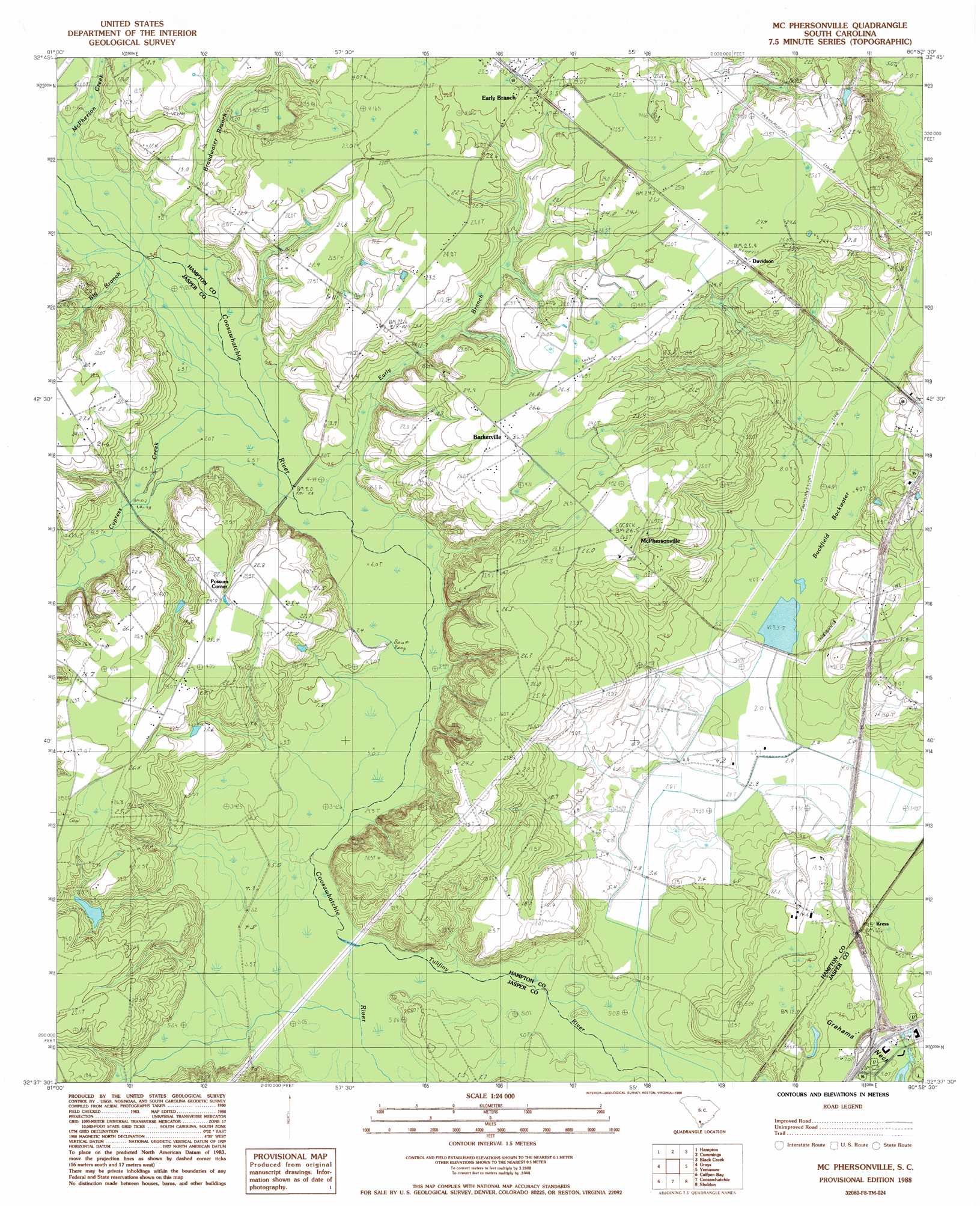
Mcphersonville Topo Map South Carolina
To zoom in, hover over the map of Mcphersonville
USGS Topo Quad 32080f8 - 1:24,000 scale
| Topo Map Name: | Mcphersonville |
| USGS Topo Quad ID: | 32080f8 |
| Print Size: | ca. 21 1/4" wide x 27" high |
| Southeast Coordinates: | 32.625° N latitude / 80.875° W longitude |
| Map Center Coordinates: | 32.6875° N latitude / 80.9375° W longitude |
| U.S. State: | SC |
| Filename: | o32080f8.jpg |
| Download Map JPG Image: | Mcphersonville topo map 1:24,000 scale |
| Map Type: | Topographic |
| Topo Series: | 7.5´ |
| Map Scale: | 1:24,000 |
| Source of Map Images: | United States Geological Survey (USGS) |
| Alternate Map Versions: |
Mc Phersonville SC 1988, updated 1988 Download PDF Buy paper map McPhersonville SC 2011 Download PDF Buy paper map McPhersonville SC 2014 Download PDF Buy paper map |
1:24,000 Topo Quads surrounding Mcphersonville
Fairfax |
Crocketville |
Islandton |
Sniders Crossroads |
Walterboro |
Gifford |
Hampton |
Cummings |
Black Creek |
Hendersonville |
Furman |
Grays |
Mcphersonville |
Yemassee |
Whitehall |
Pineland |
Calfpen Bay |
Coosawhatchie |
Sheldon |
Dale |
Hardeeville Nw |
Tillman |
Ridgeland |
Laurel Bay |
Beaufort |
> Back to 32080e1 at 1:100,000 scale
> Back to 32080a1 at 1:250,000 scale
> Back to U.S. Topo Maps home
Mcphersonville topo map: Gazetteer
Mcphersonville: Bridges
Possum Corner Bridge elevation 7m 22′Mcphersonville: Crossings
Interchange 33 elevation 7m 22′Mcphersonville: Dams
South Carolina Noname 25002 D-2602 Dam elevation 3m 9′Mcphersonville: Populated Places
Barkerville elevation 26m 85′Davidson elevation 24m 78′
Early Branch elevation 22m 72′
Kress elevation 12m 39′
McPhersonville elevation 26m 85′
Possum Corner elevation 24m 78′
Mcphersonville: Post Offices
Early Branch Post Office elevation 22m 72′Mcphersonville: Reservoirs
Buckfield Pond elevation 3m 9′Mcphersonville: Streams
Big Branch elevation 7m 22′Broadwater Branch elevation 8m 26′
Early Branch elevation 6m 19′
McPherson Creek elevation 8m 26′
Mcphersonville: Swamps
Buckfield Backwater elevation 7m 22′Mcphersonville digital topo map on disk
Buy this Mcphersonville topo map showing relief, roads, GPS coordinates and other geographical features, as a high-resolution digital map file on DVD:
South Carolina, Western North Carolina & Northeastern Georgia
Buy digital topo maps: South Carolina, Western North Carolina & Northeastern Georgia