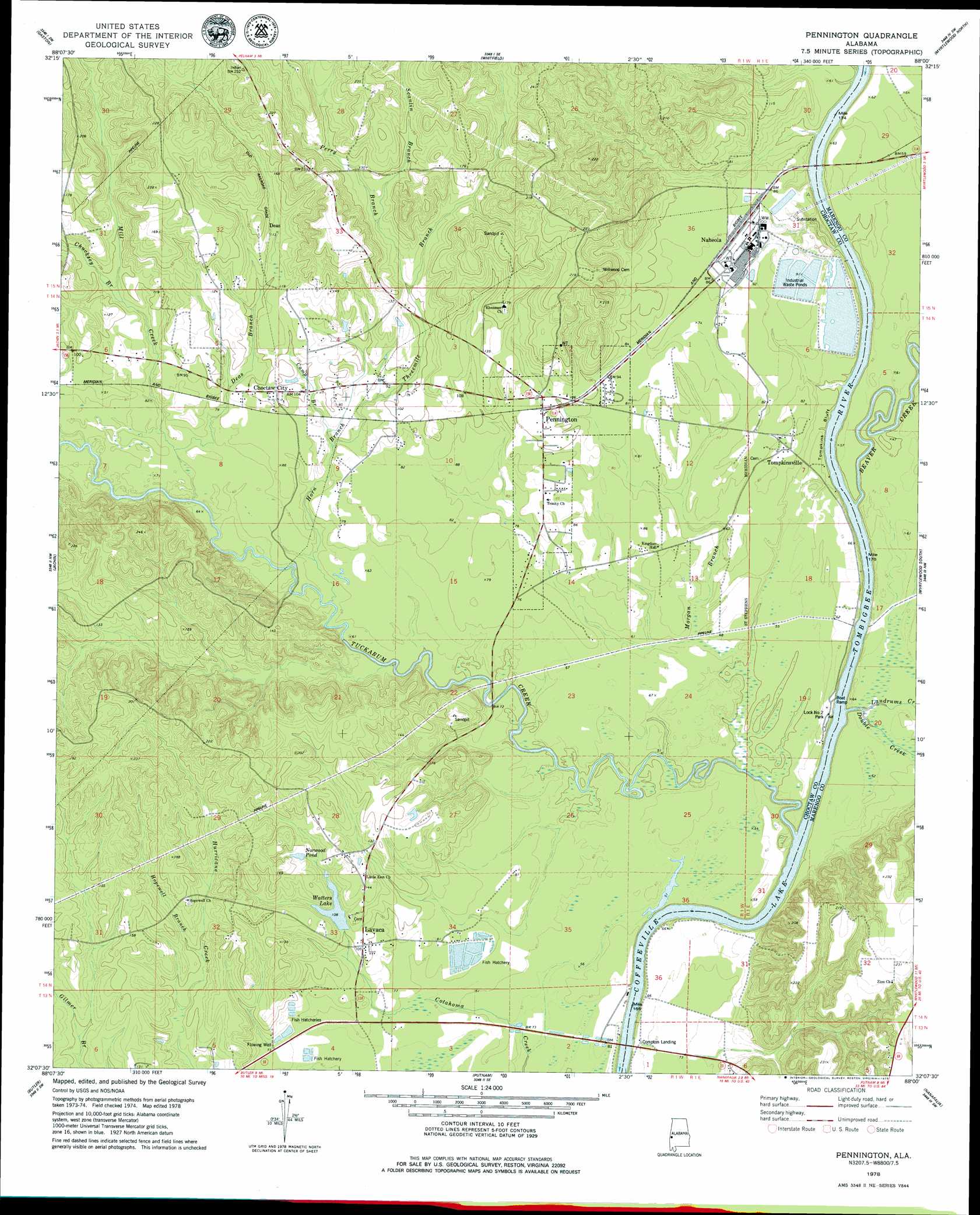
Pennington Topo Map Alabama
To zoom in, hover over the map of Pennington
USGS Topo Quad 32088b1 - 1:24,000 scale
| Topo Map Name: | Pennington |
| USGS Topo Quad ID: | 32088b1 |
| Print Size: | ca. 21 1/4" wide x 27" high |
| Southeast Coordinates: | 32.125° N latitude / 88° W longitude |
| Map Center Coordinates: | 32.1875° N latitude / 88.0625° W longitude |
| U.S. State: | AL |
| Filename: | o32088b1.jpg |
| Download Map JPG Image: | Pennington topo map 1:24,000 scale |
| Map Type: | Topographic |
| Topo Series: | 7.5´ |
| Map Scale: | 1:24,000 |
| Source of Map Images: | United States Geological Survey (USGS) |
| Alternate Map Versions: |
Pennington AL 1978, updated 1979 Download PDF Buy paper map Pennington AL 2011 Download PDF Buy paper map Pennington AL 2014 Download PDF Buy paper map |
1:24,000 Topo Quads surrounding Pennington
York |
Bellamy |
Coatopa |
Jefferson |
Old Spring Hill |
Ward |
Gaston |
Whitfield |
Myrtlewood North |
Linden |
Lisman |
Jachin |
Pennington |
Myrtlewood South |
Miller |
Land |
Butler |
Putnam |
Nanafalia |
Sweet Water |
Toxey |
Ararat |
Woods Bluff |
Morvin |
Bashi |
> Back to 32088a1 at 1:100,000 scale
> Back to 32088a1 at 1:250,000 scale
> Back to U.S. Topo Maps home
Pennington topo map: Gazetteer
Pennington: Bridges
William B Crumpton Bridge elevation 11m 36′Pennington: Channels
Marengo Chute elevation 11m 36′Pennington: Cliffs
James Bluff elevation 65m 213′Murphys Bluff elevation 20m 65′
Nanafalia Bluff elevation 40m 131′
Tompkins Bluff elevation 17m 55′
Pennington: Crossings
Lotts Ferry (historical) elevation 16m 52′Murphys Ferry (historical) elevation 20m 65′
Pennington: Dams
C A Ezell Dam elevation 20m 65′C A Ezell Fish Hatchery Dam elevation 23m 75′
Julian Waters Lake Dam elevation 39m 127′
Pennington: Parks
Lock Number Two Park elevation 20m 65′Pennington: Populated Places
Barrons (historical) elevation 69m 226′Choctaw City elevation 32m 104′
Deas elevation 49m 160′
Lavaca elevation 31m 101′
Naheola elevation 27m 88′
Pennington elevation 32m 104′
Tompkinsville elevation 24m 78′
Pennington: Reservoirs
C A Ezell Fish Hatchery elevation 23m 75′Final Mill Effluent Treatment Pon elevation 20m 65′
Norwood Pond elevation 40m 131′
Watters Lake elevation 32m 104′
Pennington: Streams
Beaver Creek elevation 11m 36′Camp Branch elevation 26m 85′
Chucksey Branch elevation 26m 85′
Deas Branch elevation 20m 65′
Double Creek elevation 11m 36′
Hill Branch elevation 18m 59′
Hopewell Branch elevation 29m 95′
Horn Branch elevation 18m 59′
Kemp Branch elevation 11m 36′
Landrums Creek elevation 12m 39′
Mill Creek elevation 18m 59′
Morgan Branch elevation 15m 49′
Morgan Branch elevation 12m 39′
Mulberry Creek elevation 15m 49′
Perry Branch elevation 42m 137′
Scanlin Branch elevation 43m 141′
Threemile Branch elevation 23m 75′
Tuckabum Creek elevation 13m 42′
Tuckabum Creek elevation 13m 42′
Pennington digital topo map on disk
Buy this Pennington topo map showing relief, roads, GPS coordinates and other geographical features, as a high-resolution digital map file on DVD:
Gulf Coast (LA, MS, AL, FL) & Southwestern Georgia
Buy digital topo maps: Gulf Coast (LA, MS, AL, FL) & Southwestern Georgia
 & Southwestern Georgia map DVD")