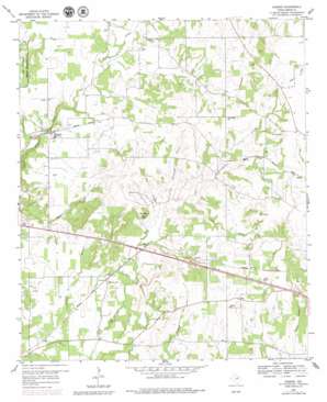
Garner Topo Map Texas
To zoom in, hover over the map of Garner
USGS Topo Quad 32097g8 - 1:24,000 scale
| Topo Map Name: | Garner |
| USGS Topo Quad ID: | 32097g8 |
| Print Size: | ca. 21 1/4" wide x 27" high |
| Southeast Coordinates: | 32.75° N latitude / 97.875° W longitude |
| Map Center Coordinates: | 32.8125° N latitude / 97.9375° W longitude |
| U.S. State: | TX |
| Filename: | o32097g8.jpg |
| Download Map JPG Image: | Garner topo map 1:24,000 scale |
| Map Type: | Topographic |
| Topo Series: | 7.5´ |
| Map Scale: | 1:24,000 |
| Source of Map Images: | United States Geological Survey (USGS) |
| Alternate Map Versions: |
Garner TX 1959, updated 1960 Download PDF Buy paper map Garner TX 1959, updated 1960 Download PDF Buy paper map Garner TX 1959, updated 1979 Download PDF Buy paper map Garner TX 2010 Download PDF Buy paper map Garner TX 2012 Download PDF Buy paper map Garner TX 2016 Download PDF Buy paper map |
1:24,000 Topo Quads surrounding Garner
> Back to 32097e1 at 1:100,000 scale
> Back to 32096a1 at 1:250,000 scale
> Back to U.S. Topo Maps home
Garner topo map: Gazetteer
Garner: Airports
Reb Folbres Place Airport elevation 287m 941′Garner: Populated Places
Authon elevation 310m 1017′Fox elevation 353m 1158′
Garner elevation 288m 944′
Lemley elevation 377m 1236′
Preble elevation 300m 984′
Garner: Streams
Beal Branch elevation 297m 974′Clark Branch elevation 308m 1010′
Cottonwood Branch elevation 299m 980′
Lick Branch elevation 290m 951′
Garner: Summits
Buzzard Hill elevation 337m 1105′Garner digital topo map on disk
Buy this Garner topo map showing relief, roads, GPS coordinates and other geographical features, as a high-resolution digital map file on DVD:


