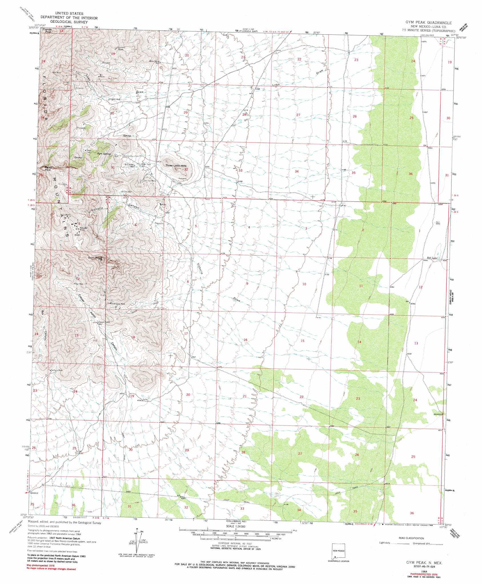
Gym Peak Topo Map New Mexico
To zoom in, hover over the map of Gym Peak
USGS Topo Quad 32107a5 - 1:24,000 scale
| Topo Map Name: | Gym Peak |
| USGS Topo Quad ID: | 32107a5 |
| Print Size: | ca. 21 1/4" wide x 27" high |
| Southeast Coordinates: | 32° N latitude / 107.5° W longitude |
| Map Center Coordinates: | 32.0625° N latitude / 107.5625° W longitude |
| U.S. State: | NM |
| Filename: | o32107a5.jpg |
| Download Map JPG Image: | Gym Peak topo map 1:24,000 scale |
| Map Type: | Topographic |
| Topo Series: | 7.5´ |
| Map Scale: | 1:24,000 |
| Source of Map Images: | United States Geological Survey (USGS) |
| Alternate Map Versions: |
Gym Peak NM 1964, updated 1967 Download PDF Buy paper map Gym Peak NM 1964, updated 1986 Download PDF Buy paper map Gym Peak NM 1996, updated 2002 Download PDF Buy paper map Gym Peak NM 2010 Download PDF Buy paper map Gym Peak NM 2013 Download PDF Buy paper map Gym Peak NM 2017 Download PDF Buy paper map |
1:24,000 Topo Quads surrounding Gym Peak
Deming West |
Deming East |
Carne |
Myndus |
Lazy E Ranch |
Bowlin Ranch |
Capitol Dome |
Florida Gap |
Akela |
Cambray |
Midway Butte |
South Peak |
Gym Peak |
Sibley Hole |
X-7 Ranch |
West Lime Hills |
North Peak |
Columbus Ne |
Mesquite Lake |
P O L Ranch |
Malpais Hill |
Columbus |
Columbus Se |
Coyote Hill |
Camel Mountain |
> Back to 32107a1 at 1:100,000 scale
> Back to 32106a1 at 1:250,000 scale
> Back to U.S. Topo Maps home
Gym Peak topo map: Gazetteer
Gym Peak: Lakes
Red Lake elevation 1232m 4041′Gym Peak: Mines
Anniversary Mine elevation 1985m 6512′Atir Mine elevation 1899m 6230′
Birchfield Group-Florida Mountains Area elevation 1452m 4763′
Birchfield Zinc Prospect elevation 1438m 4717′
Copper Ridge Mine elevation 1941m 6368′
Granada Mines elevation 1689m 5541′
Lucky John elevation 1782m 5846′
Mahoney Mines elevation 2011m 6597′
Mahoney Mines elevation 2023m 6637′
Pacheco Mine elevation 1489m 4885′
Priser Mine elevation 1697m 5567′
Prisser Mine elevation 1701m 5580′
San Tex Mine elevation 1481m 4858′
San-Tex Mine elevation 1491m 4891′
Silver Cave Mine elevation 1587m 5206′
Silver Cave Number 1 elevation 1592m 5223′
Waddell Prospect elevation 1914m 6279′
Gym Peak: Parks
Florida Mountains Wilderness Study Area elevation 2146m 7040′Gym Peak: Ranges
Florida Mountains elevation 2040m 6692′Gym Peak: Springs
Byer Spring elevation 1570m 5150′Gym Peak: Summits
Baldy Peak elevation 2121m 6958′Florida Peak elevation 2266m 7434′
Gym Peak elevation 2146m 7040′
Three Little Hills elevation 1534m 5032′
Gym Peak: Valleys
Box Canyon elevation 1469m 4819′Copper Kettle Canyon elevation 1385m 4543′
Lobo Draw elevation 1255m 4117′
Victorio Canyon elevation 1378m 4520′
Victorio Draw elevation 1265m 4150′
Gym Peak: Wells
00648 Water Well elevation 1254m 4114′00650 Water Well elevation 1498m 4914′
00652 Water Well elevation 1534m 5032′
00800 Water Well elevation 1269m 4163′
00802 Water Well elevation 1226m 4022′
00803 Water Well elevation 1229m 4032′
00805 Water Well elevation 1488m 4881′
00809 Water Well elevation 1365m 4478′
00810 Water Well elevation 1365m 4478′
01434 Water Well elevation 1267m 4156′
Blue Water Well elevation 1483m 4865′
Copper Kettle Well elevation 1488m 4881′
English Well elevation 1510m 4954′
Victorio Well elevation 1541m 5055′
White Dome Well elevation 1436m 4711′
Gym Peak digital topo map on disk
Buy this Gym Peak topo map showing relief, roads, GPS coordinates and other geographical features, as a high-resolution digital map file on DVD: