Gray Topo Map Georgia
To zoom in, hover over the map of Gray
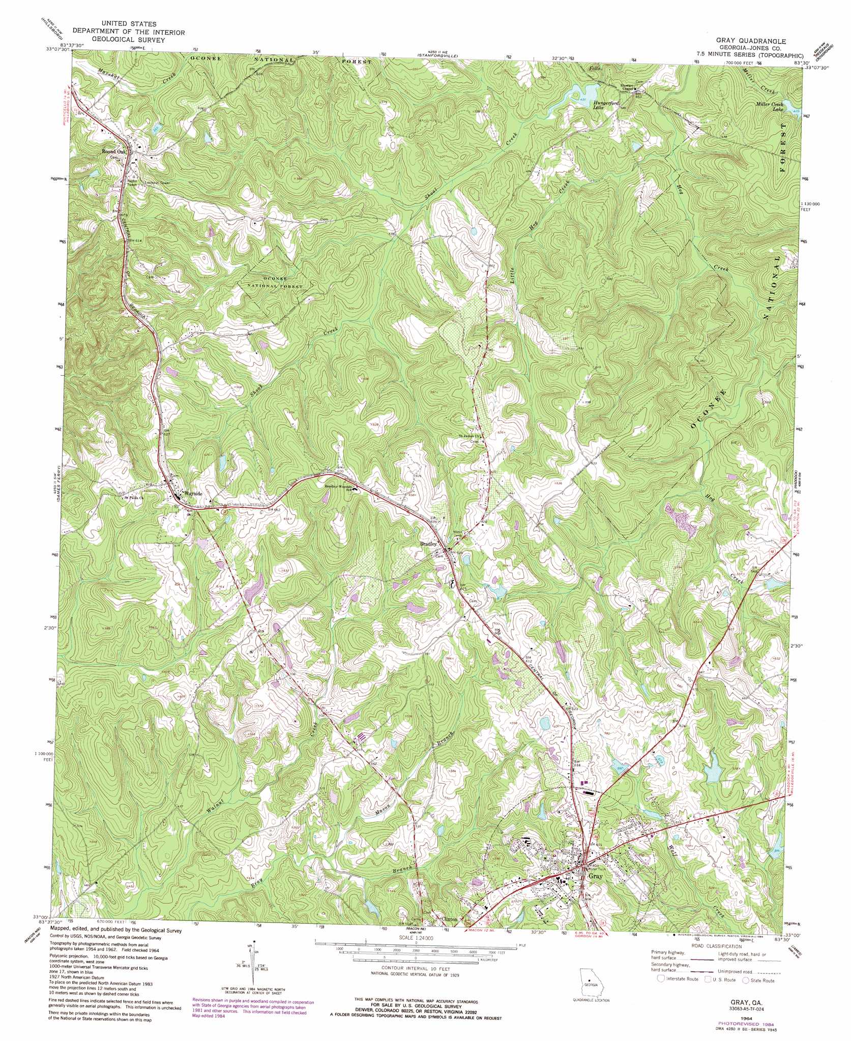
USGS Topo Quad 33083a5 - 1:24,000 scale
| Topo Map Name: | Gray |
| USGS Topo Quad ID: | 33083a5 |
| Print Size: | ca. 21 1/4" wide x 27" high |
| Southeast Coordinates: | 33° N latitude / 83.5° W longitude |
| Map Center Coordinates: | 33.0625° N latitude / 83.5625° W longitude |
| U.S. State: | GA |
| Filename: | o33083a5.jpg |
| Download Map JPG Image: | Gray topo map 1:24,000 scale |
| Map Type: | Topographic |
| Topo Series: | 7.5´ |
| Map Scale: | 1:24,000 |
| Source of Map Images: | United States Geological Survey (USGS) |
| Alternate Map Versions: |
Gray GA 1964, updated 1965 Download PDF Buy paper map Gray GA 1964, updated 1984 Download PDF Buy paper map Gray GA 2011 Download PDF Buy paper map Gray GA 2014 Download PDF Buy paper map |
| FStopo: | US Forest Service topo Gray is available: Download FStopo PDF Download FStopo TIF |
1:24,000 Topo Quads surrounding Gray
Lloyd Shoals Dam |
Monticello |
Smithboro |
Eatonton |
Meda |
Berner |
Hillsboro |
Stanfordville |
Resseaus Crossroads |
Lake Sinclair West |
East Juliette |
Dames Ferry |
Gray |
Haddock |
Browns Crossing |
Bolingbroke |
Macon Nw |
Macon Ne |
James |
Gordon |
Lizella |
Macon West |
Macon East |
Dry Branch |
Massey Hill |
> Back to 33083a1 at 1:100,000 scale
> Back to 33082a1 at 1:250,000 scale
> Back to U.S. Topo Maps home
Gray topo map: Gazetteer
Gray: Dams
Briscoe Dam elevation 157m 515′Cheatham Dam elevation 166m 544′
Douglas Lake Dam elevation 166m 544′
Hulett Dam elevation 153m 501′
Hungerford Lake Dam elevation 130m 426′
Lowe Lake Dam elevation 174m 570′
Miller Creek Lake Dam elevation 131m 429′
Moore Lake Dam elevation 165m 541′
Rowland Dam elevation 167m 547′
Ussery Lake Dam elevation 169m 554′
Gray: Populated Places
Bradley elevation 191m 626′Bragg elevation 188m 616′
Campbell (historical) elevation 188m 616′
Gray elevation 184m 603′
Round Oak elevation 190m 623′
Wayside elevation 195m 639′
Gray: Reservoirs
Briscoe Lake elevation 157m 515′Cheatham Lake elevation 166m 544′
Douglas Lake elevation 166m 544′
Hulett Lake elevation 153m 501′
Hungerford Lake elevation 130m 426′
Lowe Lake elevation 174m 570′
Miller Creek Lake elevation 131m 429′
Moore Lake elevation 165m 541′
Rowland Lake elevation 167m 547′
Ussery Lake elevation 169m 554′
Gray: Streams
Little Chehaw Creek elevation 146m 479′Little Hog Creek elevation 118m 387′
Mason Branch elevation 136m 446′
Gray digital topo map on disk
Buy this Gray topo map showing relief, roads, GPS coordinates and other geographical features, as a high-resolution digital map file on DVD:
South Carolina, Western North Carolina & Northeastern Georgia
Buy digital topo maps: South Carolina, Western North Carolina & Northeastern Georgia