Princeton West Topo Map Arkansas
To zoom in, hover over the map of Princeton West
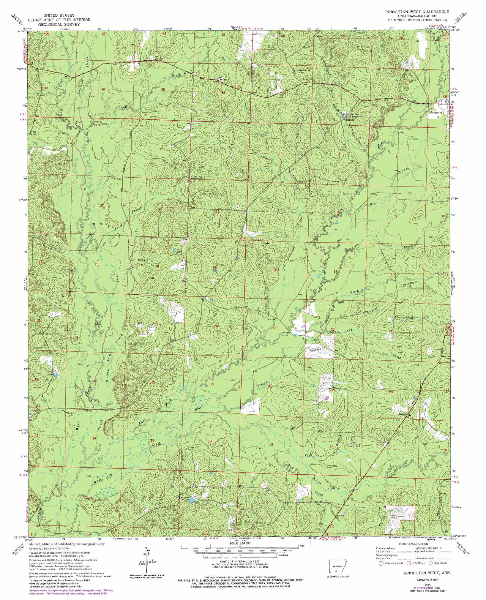
USGS Topo Quad 33092h6 - 1:24,000 scale
| Topo Map Name: | Princeton West |
| USGS Topo Quad ID: | 33092h6 |
| Print Size: | ca. 21 1/4" wide x 27" high |
| Southeast Coordinates: | 33.875° N latitude / 92.625° W longitude |
| Map Center Coordinates: | 33.9375° N latitude / 92.6875° W longitude |
| U.S. State: | AR |
| Filename: | o33092h6.jpg |
| Download Map JPG Image: | Princeton West topo map 1:24,000 scale |
| Map Type: | Topographic |
| Topo Series: | 7.5´ |
| Map Scale: | 1:24,000 |
| Source of Map Images: | United States Geological Survey (USGS) |
| Alternate Map Versions: |
Princeton West AR 1973, updated 1975 Download PDF Buy paper map Princeton West AR 1973, updated 1986 Download PDF Buy paper map Princeton West AR 2011 Download PDF Buy paper map Princeton West AR 2014 Download PDF Buy paper map |
1:24,000 Topo Quads surrounding Princeton West
Donaldson |
Round Hill |
Willow |
Leola |
Millerville |
Dalark |
Manning |
Tulip |
Carthage |
Bunn |
Sparkman Nw |
Sparkman |
Princeton West |
Princeton East |
Ivan |
Tates Bluff |
Ouachita |
Holly Springs |
Hopeville |
Fordyce |
Bragg City |
Harmony Grove |
Eagle Mills |
Bearden |
Chambersville |
> Back to 33092e1 at 1:100,000 scale
> Back to 33092a1 at 1:250,000 scale
> Back to U.S. Topo Maps home
Princeton West topo map: Gazetteer
Princeton West: Guts
Alsobrook Slough elevation 64m 209′Black Slough elevation 55m 180′
Hickory Flats Slough elevation 55m 180′
Long Slough elevation 53m 173′
Princeton West: Populated Places
Cruse (historical) elevation 72m 236′Jacinto elevation 84m 275′
Nix (historical) elevation 72m 236′
Oakhurst (historical) elevation 90m 295′
Princeton West: Streams
Bear Creek elevation 58m 190′Beech Creek elevation 62m 203′
Campground Creek elevation 68m 223′
Cooker Branch elevation 60m 196′
Dry Creek elevation 76m 249′
Dry Creek elevation 58m 190′
East Fork Tulip Creek elevation 53m 173′
Futch Branch elevation 62m 203′
Hall Creek elevation 63m 206′
Martin Creek elevation 64m 209′
Mitchell Branch elevation 69m 226′
Mud Creek elevation 58m 190′
Pride Branch elevation 55m 180′
Red Branch elevation 65m 213′
Sand Creek elevation 62m 203′
Taylor Branch elevation 58m 190′
West Fork Tulip Creek elevation 53m 173′
White Oak Creek elevation 60m 196′
Princeton West digital topo map on disk
Buy this Princeton West topo map showing relief, roads, GPS coordinates and other geographical features, as a high-resolution digital map file on DVD: