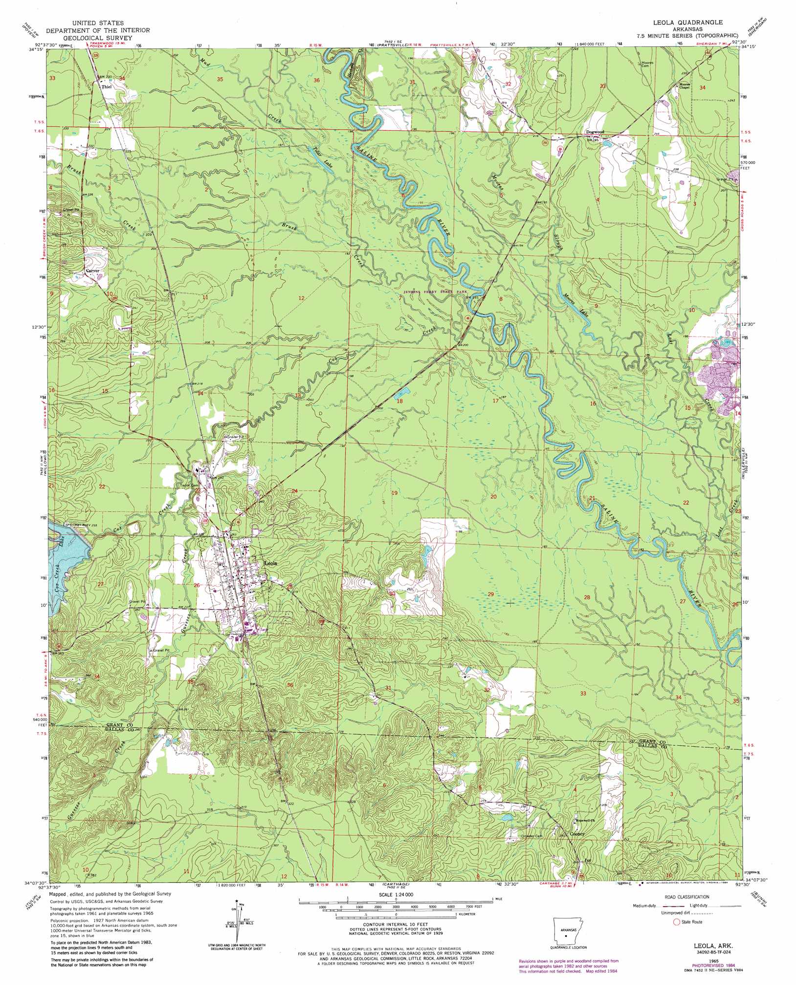
Leola Topo Map Arkansas
To zoom in, hover over the map of Leola
USGS Topo Quad 34092b5 - 1:24,000 scale
| Topo Map Name: | Leola |
| USGS Topo Quad ID: | 34092b5 |
| Print Size: | ca. 21 1/4" wide x 27" high |
| Southeast Coordinates: | 34.125° N latitude / 92.5° W longitude |
| Map Center Coordinates: | 34.1875° N latitude / 92.5625° W longitude |
| U.S. State: | AR |
| Filename: | o34092b5.jpg |
| Download Map JPG Image: | Leola topo map 1:24,000 scale |
| Map Type: | Topographic |
| Topo Series: | 7.5´ |
| Map Scale: | 1:24,000 |
| Source of Map Images: | United States Geological Survey (USGS) |
| Alternate Map Versions: |
Leola AR 1965, updated 1966 Download PDF Buy paper map Leola AR 1965, updated 1980 Download PDF Buy paper map Leola AR 1965, updated 1984 Download PDF Buy paper map Leola AR 2011 Download PDF Buy paper map Leola AR 2014 Download PDF Buy paper map |
1:24,000 Topo Quads surrounding Leola
Malvern North |
Traskwood |
Tull |
Belfast |
Cane Creek |
Malvern South |
Poyen |
Prattsville |
Sheridan |
Prague |
Round Hill |
Willow |
Leola |
Millerville |
Grapevine |
Manning |
Tulip |
Carthage |
Bunn |
Staves |
Sparkman |
Princeton West |
Princeton East |
Ivan |
Fordyce Ne |
> Back to 34092a1 at 1:100,000 scale
> Back to 34092a1 at 1:250,000 scale
> Back to U.S. Topo Maps home
Leola topo map: Gazetteer
Leola: Airports
Katheryns Landing Airport elevation 76m 249′Leola: Dams
Cox Creek Lake Dam elevation 81m 265′Leola: Lakes
Moores Lake elevation 56m 183′Tolar Lake elevation 61m 200′
Leola: Parks
Jenkins Ferry State Park elevation 56m 183′Leola: Populated Places
Carver elevation 73m 239′Cooney elevation 79m 259′
Dogwood elevation 74m 242′
Ivy elevation 79m 259′
Leola elevation 84m 275′
Thiel elevation 71m 232′
Leola: Reservoirs
Cox Creek Lake elevation 81m 265′Leola: Streams
Brush Creek elevation 56m 183′Cox Creek elevation 58m 190′
Guesses Creek elevation 66m 216′
Herbert Creek elevation 60m 196′
Moores Slough elevation 56m 183′
Mud Creek elevation 59m 193′
Leola digital topo map on disk
Buy this Leola topo map showing relief, roads, GPS coordinates and other geographical features, as a high-resolution digital map file on DVD: