Woodbine Topo Map Texas
To zoom in, hover over the map of Woodbine
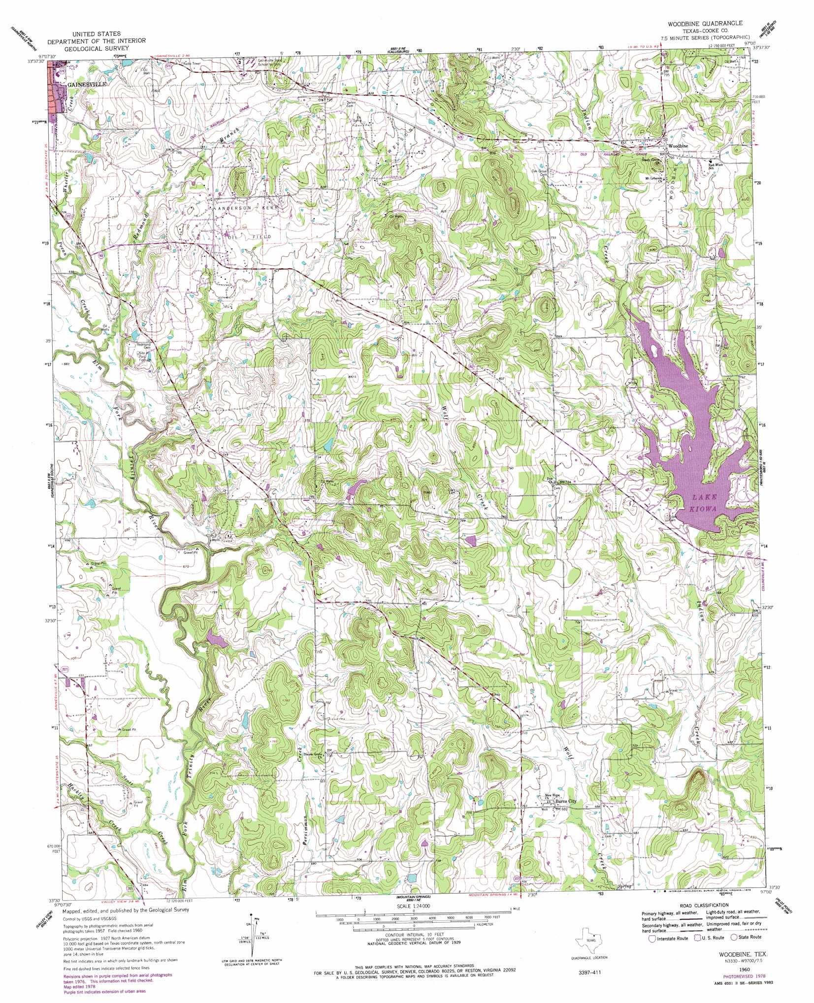
USGS Topo Quad 33097e1 - 1:24,000 scale
| Topo Map Name: | Woodbine |
| USGS Topo Quad ID: | 33097e1 |
| Print Size: | ca. 21 1/4" wide x 27" high |
| Southeast Coordinates: | 33.5° N latitude / 97° W longitude |
| Map Center Coordinates: | 33.5625° N latitude / 97.0625° W longitude |
| U.S. State: | TX |
| Filename: | o33097e1.jpg |
| Download Map JPG Image: | Woodbine topo map 1:24,000 scale |
| Map Type: | Topographic |
| Topo Series: | 7.5´ |
| Map Scale: | 1:24,000 |
| Source of Map Images: | United States Geological Survey (USGS) |
| Alternate Map Versions: |
Woodbine TX 1960, updated 1964 Download PDF Buy paper map Woodbine TX 1960, updated 1978 Download PDF Buy paper map Woodbine TX 2010 Download PDF Buy paper map Woodbine TX 2013 Download PDF Buy paper map Woodbine TX 2016 Download PDF Buy paper map |
1:24,000 Topo Quads surrounding Woodbine
Marysville |
Thackerville |
Horseshoe Bend |
Dexter |
Gordonville |
Muenster East |
Gainesville North |
Callisburg |
Whitesboro |
Sadler |
Hood |
Gainesville South |
Woodbine |
Collinsville |
Ethel |
Era |
Valley View |
Mountain Springs |
Pilot Point |
Marilee |
Era Se |
Sanger |
Green Valley |
Aubrey |
Celina |
> Back to 33097e1 at 1:100,000 scale
> Back to 33096a1 at 1:250,000 scale
> Back to U.S. Topo Maps home
Woodbine topo map: Gazetteer
Woodbine: Dams
Lake Kiowa Dam elevation 206m 675′Soil Conservation Service Site 16b Dam elevation 195m 639′
Woodbine: Oilfields
Anderson-Kerr Oil Field elevation 236m 774′The Wilson Pool elevation 248m 813′
Woodbine: Parks
Site of Fort Fitzhugh elevation 223m 731′Woodbine: Populated Places
Burns City elevation 208m 682′Lake Kiowa elevation 216m 708′
Woodbine elevation 236m 774′
Woodbine: Reservoirs
Lake Kiowa elevation 212m 695′Soil Conservation Service Site 16b Reservoir elevation 195m 639′
Woodbine: Streams
Hackley Creek elevation 192m 629′Pecan Creek elevation 203m 666′
Redmond Branch elevation 200m 656′
Scott Creek elevation 191m 626′
Wheeler Creek elevation 210m 688′
Woodbine digital topo map on disk
Buy this Woodbine topo map showing relief, roads, GPS coordinates and other geographical features, as a high-resolution digital map file on DVD: