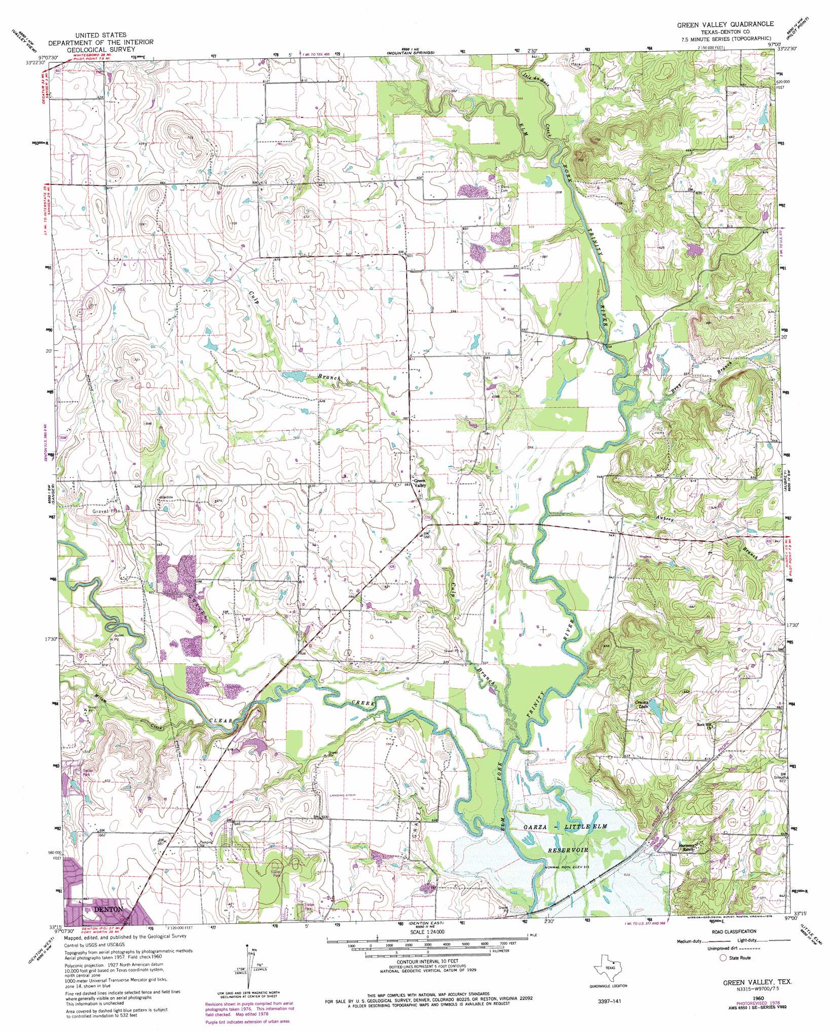
Green Valley Topo Map Texas
To zoom in, hover over the map of Green Valley
USGS Topo Quad 33097c1 - 1:24,000 scale
| Topo Map Name: | Green Valley |
| USGS Topo Quad ID: | 33097c1 |
| Print Size: | ca. 21 1/4" wide x 27" high |
| Southeast Coordinates: | 33.25° N latitude / 97° W longitude |
| Map Center Coordinates: | 33.3125° N latitude / 97.0625° W longitude |
| U.S. State: | TX |
| Filename: | o33097c1.jpg |
| Download Map JPG Image: | Green Valley topo map 1:24,000 scale |
| Map Type: | Topographic |
| Topo Series: | 7.5´ |
| Map Scale: | 1:24,000 |
| Source of Map Images: | United States Geological Survey (USGS) |
| Alternate Map Versions: |
Green Valley TX 1960, updated 1961 Download PDF Buy paper map Green Valley TX 1960, updated 1973 Download PDF Buy paper map Green Valley TX 1960, updated 1978 Download PDF Buy paper map Green Valley TX 1960, updated 1978 Download PDF Buy paper map Green Valley TX 2010 Download PDF Buy paper map Green Valley TX 2013 Download PDF Buy paper map Green Valley TX 2016 Download PDF Buy paper map |
1:24,000 Topo Quads surrounding Green Valley
Hood |
Gainesville South |
Woodbine |
Collinsville |
Ethel |
Era |
Valley View |
Mountain Springs |
Pilot Point |
Marilee |
Era Se |
Sanger |
Green Valley |
Aubrey |
Celina |
Ponder |
Denton West |
Denton East |
Little Elm |
Frisco |
Justin |
Argyle |
Lewisville West |
Lewisville East |
Hebron |
> Back to 33097a1 at 1:100,000 scale
> Back to 33096a1 at 1:250,000 scale
> Back to U.S. Topo Maps home
Green Valley topo map: Gazetteer
Green Valley: Airports
Hartlee Field elevation 177m 580′Warschun Ranch Airport elevation 177m 580′
Windy Hill Airport elevation 203m 666′
Green Valley: Dams
Evans Lake Dam elevation 179m 587′McCallum Lake Dam elevation 183m 600′
Green Valley: Parks
Ray Roberts Lake State Recreation Area - Culp Branch Unit elevation 195m 639′Green Valley: Populated Places
Green Valley elevation 181m 593′Green Valley: Reservoirs
Crains Lake elevation 177m 580′Evans Lake elevation 179m 587′
McCallum Lake elevation 183m 600′
Ray Roberts Lake elevation 164m 538′
Green Valley: Streams
Aubrey Branch elevation 162m 531′Bray Branch elevation 162m 531′
Clear Creek elevation 158m 518′
Culp Branch elevation 161m 528′
Isle du Bois Creek elevation 165m 541′
Milam Creek elevation 162m 531′
Green Valley: Trails
Ray Roberts Greenbelt Corridor Trail elevation 166m 544′Green Valley digital topo map on disk
Buy this Green Valley topo map showing relief, roads, GPS coordinates and other geographical features, as a high-resolution digital map file on DVD: