Apache Peak Topo Map New Mexico
To zoom in, hover over the map of Apache Peak
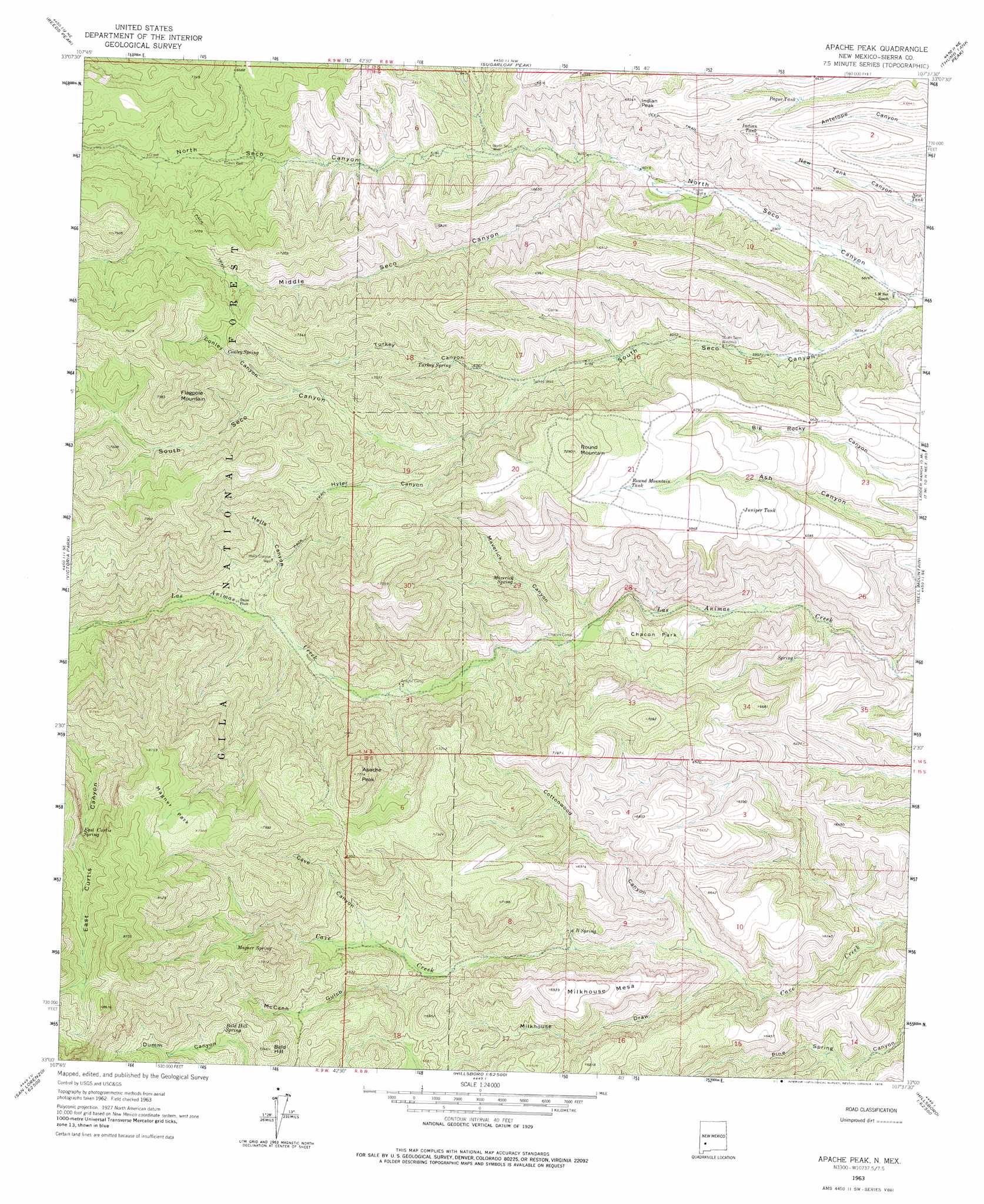
USGS Topo Quad 33107a6 - 1:24,000 scale
| Topo Map Name: | Apache Peak |
| USGS Topo Quad ID: | 33107a6 |
| Print Size: | ca. 21 1/4" wide x 27" high |
| Southeast Coordinates: | 33° N latitude / 107.625° W longitude |
| Map Center Coordinates: | 33.0625° N latitude / 107.6875° W longitude |
| U.S. State: | NM |
| Filename: | o33107a6.jpg |
| Download Map JPG Image: | Apache Peak topo map 1:24,000 scale |
| Map Type: | Topographic |
| Topo Series: | 7.5´ |
| Map Scale: | 1:24,000 |
| Source of Map Images: | United States Geological Survey (USGS) |
| Alternate Map Versions: |
Apache Peak NM 1963, updated 1966 Download PDF Buy paper map Apache Peak NM 1963, updated 1975 Download PDF Buy paper map Apache Peak NM 2011 Download PDF Buy paper map Apache Peak NM 2013 Download PDF Buy paper map Apache Peak NM 2017 Download PDF Buy paper map |
| FStopo: | US Forest Service topo Apache Peak is available: Download FStopo PDF Download FStopo TIF |
1:24,000 Topo Quads surrounding Apache Peak
Baily Points |
Lookout Mountain |
Winston |
Chise |
Priest Tank |
Bonner Canyon |
Reeds Peak |
Sugarloaf Peak |
Thumb Tank Peak |
Williamsburg Nw |
Hay Mesa |
Victoria Park |
Apache Peak |
Bell Mountain |
Saladone Tank |
Hendricks Peak |
Hillsboro Peak |
Kingston |
Hillsboro |
Skute Stone Arroyo |
San Lorenzo |
Maverick Mountain |
Pa Mountain |
Mcclede Mountain |
Clark Spring Canyon |
> Back to 33107a1 at 1:100,000 scale
> Back to 33106a1 at 1:250,000 scale
> Back to U.S. Topo Maps home
Apache Peak topo map: Gazetteer
Apache Peak: Flats
Chacon Park elevation 1854m 6082′Magner Park elevation 2416m 7926′
Apache Peak: Mines
Ingersoll Mine elevation 2106m 6909′Apache Peak: Reservoirs
Indian Tank elevation 2025m 6643′Juniper Tank elevation 2070m 6791′
New Tank elevation 1902m 6240′
Pague Tank elevation 1919m 6295′
Round Mountain Tank elevation 2098m 6883′
Apache Peak: Springs
Bald Hill Spring elevation 2152m 7060′Beam Spring elevation 2120m 6955′
Conley Spring elevation 2104m 6902′
East Curtis Spring elevation 2306m 7565′
Escondida Spring elevation 1915m 6282′
Magnum Spring elevation 2220m 7283′
Maverick Spring elevation 1863m 6112′
Six B Spring elevation 1906m 6253′
Turkey Spring elevation 1960m 6430′
Apache Peak: Streams
Middle Seco Creek elevation 1837m 6026′North Seco Creek elevation 1768m 5800′
South Seco Creek elevation 1771m 5810′
Apache Peak: Summits
Apache Peak elevation 2309m 7575′Bald Hill elevation 2222m 7290′
Flagpole Mountain elevation 2402m 7880′
Indian Peak elevation 2075m 6807′
Milkhouse Mesa elevation 2108m 6916′
Round Mountain elevation 2220m 7283′
Apache Peak: Valleys
Cave Canyon elevation 1959m 6427′Conley Canyon elevation 2033m 6669′
Cottonwood Canyon elevation 1823m 5980′
Hells Canyon elevation 1846m 6056′
Hyler Canyon elevation 1951m 6400′
Maverick Canyon elevation 1778m 5833′
McCann Gulch elevation 1927m 6322′
Middle Seco Canyon elevation 1945m 6381′
Milkhouse Draw elevation 1810m 5938′
Turkey Canyon elevation 1916m 6286′
Apache Peak: Wells
Davis Well elevation 1943m 6374′Hells Canyon Well elevation 1918m 6292′
North Seco Well elevation 1878m 6161′
Pague Well elevation 1821m 5974′
Turkey Well elevation 1910m 6266′
Apache Peak digital topo map on disk
Buy this Apache Peak topo map showing relief, roads, GPS coordinates and other geographical features, as a high-resolution digital map file on DVD: