Apache Junction Topo Map Arizona
To zoom in, hover over the map of Apache Junction
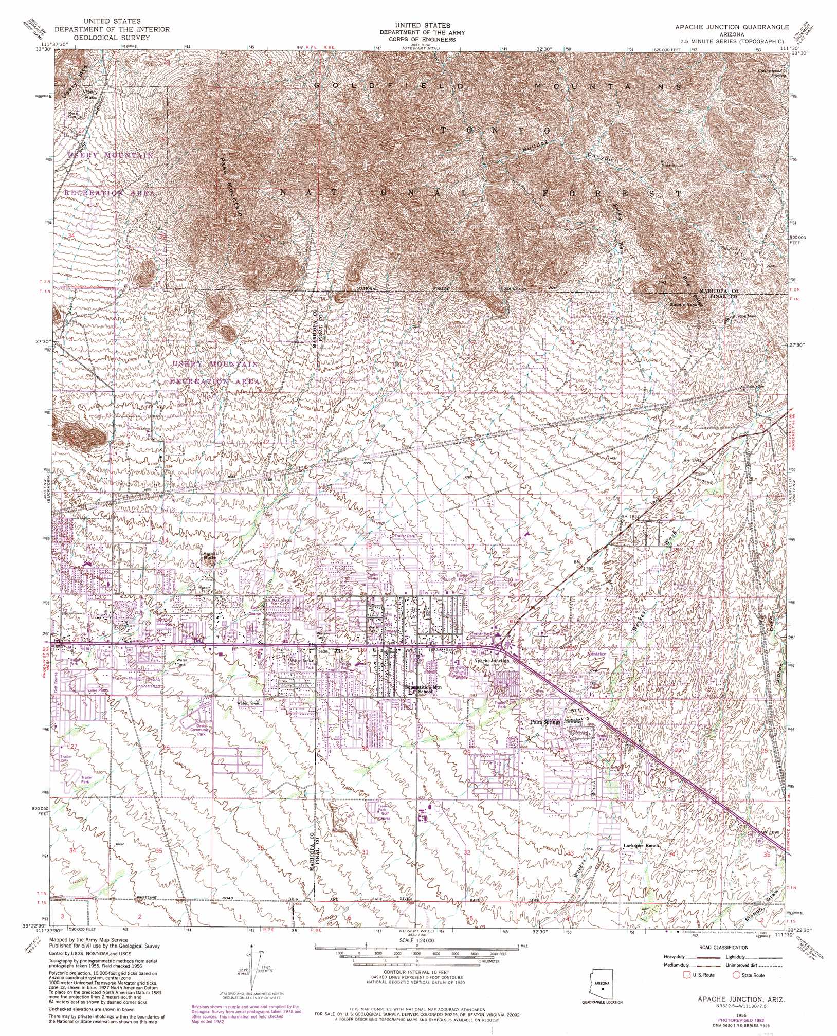
USGS Topo Quad 33111d5 - 1:24,000 scale
| Topo Map Name: | Apache Junction |
| USGS Topo Quad ID: | 33111d5 |
| Print Size: | ca. 21 1/4" wide x 27" high |
| Southeast Coordinates: | 33.375° N latitude / 111.5° W longitude |
| Map Center Coordinates: | 33.4375° N latitude / 111.5625° W longitude |
| U.S. State: | AZ |
| Filename: | o33111d5.jpg |
| Download Map JPG Image: | Apache Junction topo map 1:24,000 scale |
| Map Type: | Topographic |
| Topo Series: | 7.5´ |
| Map Scale: | 1:24,000 |
| Source of Map Images: | United States Geological Survey (USGS) |
| Alternate Map Versions: |
Apache Junction AZ 1956, updated 1959 Download PDF Buy paper map Apache Junction AZ 1956, updated 1965 Download PDF Buy paper map Apache Junction AZ 1956, updated 1975 Download PDF Buy paper map Apache Junction AZ 1956, updated 1983 Download PDF Buy paper map Apache Junction AZ 1956, updated 1983 Download PDF Buy paper map Apache Junction AZ 1971, updated 1972 Download PDF Buy paper map Apache Junction AZ 2004, updated 2007 Download PDF Buy paper map Apache Junction AZ 2011 Download PDF Buy paper map Apache Junction AZ 2014 Download PDF Buy paper map |
| FStopo: | US Forest Service topo Apache Junction is available: Download FStopo PDF Download FStopo TIF |
1:24,000 Topo Quads surrounding Apache Junction
Mcdowell Peak |
Fort Mcdowell |
Adams Mesa |
Mine Mountain |
Four Peaks |
Sawik Mountain |
Granite Reef Dam |
Stewart Mountain |
Mormon Flat Dam |
Horse Mesa Dam |
Mesa |
Buckhorn |
Apache Junction |
Goldfield |
Weavers Needle |
Chandler |
Higley |
Desert Well |
Superstition Mountains Sw |
Florence Junction |
Gila Butte |
Chandler Heights |
Sacaton Ne |
Magma |
Florence Ne |
> Back to 33111a1 at 1:100,000 scale
> Back to 33110a1 at 1:250,000 scale
> Back to U.S. Topo Maps home
Apache Junction topo map: Gazetteer
Apache Junction: Airports
Lost Dutchman Heliport elevation 536m 1758′Apache Junction: Flats
Usery Mountain Park elevation 628m 2060′Apache Junction: Gaps
Usery Pass elevation 646m 2119′Apache Junction: Mines
Bulldog Mine elevation 627m 2057′Apache Junction: Parks
Oasis Community Park elevation 480m 1574′Superstition Park East Number Two elevation 534m 1751′
Superstition Park West Number One elevation 534m 1751′
Usery Mountain Regional Park elevation 576m 1889′
Apache Junction: Populated Places
Apache Acres Trailer Park elevation 488m 1601′Apache Junction elevation 525m 1722′
Blue Star Mobile Home Park elevation 491m 1610′
Cherokee Mobile Village elevation 485m 1591′
Coral Sands Mobile Estates elevation 502m 1646′
Danas Trailer Ranch elevation 485m 1591′
Desert Village Mobile Home Park elevation 470m 1541′
La Casa Trail Mobile Villa elevation 494m 1620′
Lost Dutchman Mobile Home Park elevation 490m 1607′
Meridiancheri Mobile Home Park elevation 503m 1650′
Pacific Mobile Manor elevation 477m 1564′
Palm Springs elevation 524m 1719′
Shady Rest Mobile Home Park elevation 497m 1630′
Superstition Shadows Mobile Home Park elevation 494m 1620′
Trails West Mobile Home Park elevation 488m 1601′
Twin Acres Family Mobile Park elevation 476m 1561′
Valley Palms Mobile Home Park elevation 473m 1551′
Western Acres Mobile Park elevation 472m 1548′
Apache Junction: Ridges
Blue Ridge elevation 747m 2450′Apache Junction: Springs
Cottonwood Spring elevation 637m 2089′Apache Junction: Streams
Bulldog Wash elevation 522m 1712′Apache Junction: Summits
Orohai Mountains elevation 750m 2460′Pass Mountain elevation 1007m 3303′
Saddle Rock elevation 715m 2345′
Signal Butte elevation 518m 1699′
Apache Junction digital topo map on disk
Buy this Apache Junction topo map showing relief, roads, GPS coordinates and other geographical features, as a high-resolution digital map file on DVD: