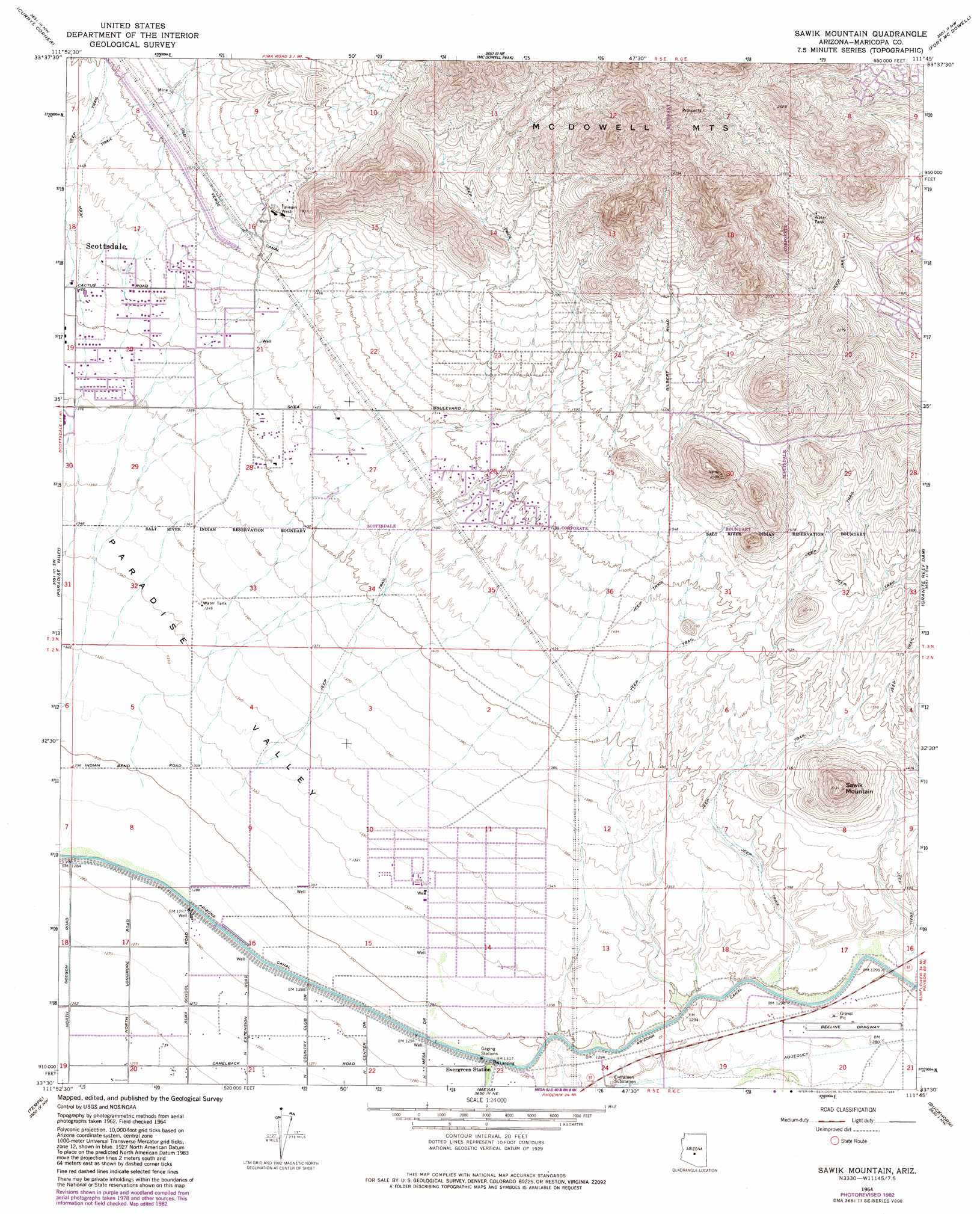
Sawik Mountain Topo Map Arizona
To zoom in, hover over the map of Sawik Mountain
USGS Topo Quad 33111e7 - 1:24,000 scale
| Topo Map Name: | Sawik Mountain |
| USGS Topo Quad ID: | 33111e7 |
| Print Size: | ca. 21 1/4" wide x 27" high |
| Southeast Coordinates: | 33.5° N latitude / 111.75° W longitude |
| Map Center Coordinates: | 33.5625° N latitude / 111.8125° W longitude |
| U.S. State: | AZ |
| Filename: | o33111e7.jpg |
| Download Map JPG Image: | Sawik Mountain topo map 1:24,000 scale |
| Map Type: | Topographic |
| Topo Series: | 7.5´ |
| Map Scale: | 1:24,000 |
| Source of Map Images: | United States Geological Survey (USGS) |
| Alternate Map Versions: |
Sawik Mountain AZ 1964, updated 1965 Download PDF Buy paper map Sawik Mountain AZ 1964, updated 1971 Download PDF Buy paper map Sawik Mountain AZ 1964, updated 1977 Download PDF Buy paper map Sawik Mountain AZ 1964, updated 1983 Download PDF Buy paper map Sawik Mountain AZ 1964, updated 1983 Download PDF Buy paper map Sawik Mountain AZ 1971, updated 1972 Download PDF Buy paper map Sawik Mountain AZ 2011 Download PDF Buy paper map Sawik Mountain AZ 2014 Download PDF Buy paper map |
1:24,000 Topo Quads surrounding Sawik Mountain
New River Se |
Cave Creek |
Wildcat Hill |
Bartlett Dam |
Maverick Mountain |
Union Hills |
Currys Corner |
Mcdowell Peak |
Fort Mcdowell |
Adams Mesa |
Sunnyslope |
Paradise Valley |
Sawik Mountain |
Granite Reef Dam |
Stewart Mountain |
Phoenix |
Tempe |
Mesa |
Buckhorn |
Apache Junction |
Lone Butte |
Guadalupe |
Chandler |
Higley |
Desert Well |
> Back to 33111e1 at 1:100,000 scale
> Back to 33110a1 at 1:250,000 scale
> Back to U.S. Topo Maps home
Sawik Mountain topo map: Gazetteer
Sawik Mountain: Arroyos
Lost Dog Wash elevation 464m 1522′Taliesin Wash elevation 463m 1519′
Sawik Mountain: Dams
Fountain Hills Dam Number Seven elevation 574m 1883′Sawik Mountain: Gaps
Taliesin Overlook elevation 634m 2080′Sawik Mountain: Populated Places
Andalusia elevation 412m 1351′Cactus Villa elevation 427m 1400′
Casa Rica elevation 427m 1400′
Chimney Hill elevation 425m 1394′
Continental Village elevation 416m 1364′
Ensenada del Oro elevation 419m 1374′
Haciendas del Lago elevation 418m 1371′
Heritage Court elevation 423m 1387′
Mirador elevation 418m 1371′
Mission Monterey elevation 415m 1361′
Preston Hills elevation 422m 1384′
Scottsdale Ranch elevation 419m 1374′
Shiloh Canyon elevation 430m 1410′
Taliesin West elevation 494m 1620′
Sawik Mountain: Springs
Canon Spring elevation 433m 1420′Sawik Mountain: Summits
Sawik Mountain elevation 0m 0′Sawik Mountain digital topo map on disk
Buy this Sawik Mountain topo map showing relief, roads, GPS coordinates and other geographical features, as a high-resolution digital map file on DVD: