Buckhorn Topo Map Arizona
To zoom in, hover over the map of Buckhorn
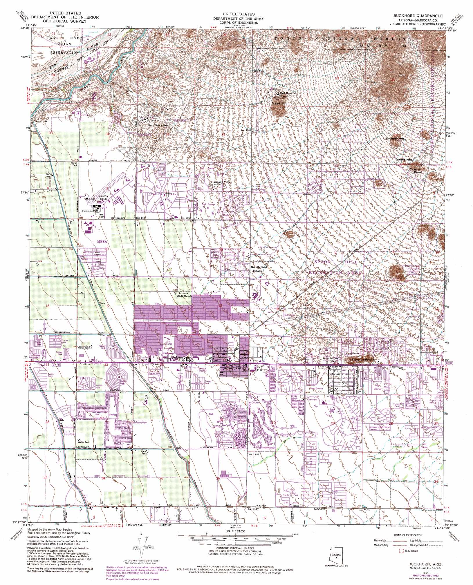
USGS Topo Quad 33111d6 - 1:24,000 scale
| Topo Map Name: | Buckhorn |
| USGS Topo Quad ID: | 33111d6 |
| Print Size: | ca. 21 1/4" wide x 27" high |
| Southeast Coordinates: | 33.375° N latitude / 111.625° W longitude |
| Map Center Coordinates: | 33.4375° N latitude / 111.6875° W longitude |
| U.S. State: | AZ |
| Filename: | o33111d6.jpg |
| Download Map JPG Image: | Buckhorn topo map 1:24,000 scale |
| Map Type: | Topographic |
| Topo Series: | 7.5´ |
| Map Scale: | 1:24,000 |
| Source of Map Images: | United States Geological Survey (USGS) |
| Alternate Map Versions: |
Buckhorn AZ 1956, updated 1959 Download PDF Buy paper map Buckhorn AZ 1956, updated 1967 Download PDF Buy paper map Buckhorn AZ 1956, updated 1975 Download PDF Buy paper map Buckhorn AZ 1956, updated 1983 Download PDF Buy paper map Buckhorn AZ 1956, updated 1983 Download PDF Buy paper map Buckhorn AZ 1971, updated 1972 Download PDF Buy paper map Buckhorn AZ 2004, updated 2007 Download PDF Buy paper map Buckhorn AZ 2011 Download PDF Buy paper map Buckhorn AZ 2014 Download PDF Buy paper map |
| FStopo: | US Forest Service topo Buckhorn is available: Download FStopo PDF Download FStopo TIF |
1:24,000 Topo Quads surrounding Buckhorn
Currys Corner |
Mcdowell Peak |
Fort Mcdowell |
Adams Mesa |
Mine Mountain |
Paradise Valley |
Sawik Mountain |
Granite Reef Dam |
Stewart Mountain |
Mormon Flat Dam |
Tempe |
Mesa |
Buckhorn |
Apache Junction |
Goldfield |
Guadalupe |
Chandler |
Higley |
Desert Well |
Superstition Mountains Sw |
Gila Butte Nw |
Gila Butte |
Chandler Heights |
Sacaton Ne |
Magma |
> Back to 33111a1 at 1:100,000 scale
> Back to 33110a1 at 1:250,000 scale
> Back to U.S. Topo Maps home
Buckhorn topo map: Gazetteer
Buckhorn: Airports
American Telephone and Telegraph- Apache Junction Heliport elevation 769m 2522′Apache Junction Airport elevation 779m 2555′
Falcon Field elevation 420m 1377′
McDonnell Douglas Heliport elevation 418m 1371′
Turf Heliport elevation 419m 1374′
Valley Lutheran Hospital Heliport elevation 424m 1391′
Valley Lutheran Hospital Heliport elevation 425m 1394′
Buckhorn: Canals
Southern Canal elevation 401m 1315′Buckhorn: Dams
Spook Hill Dam elevation 476m 1561′Buckhorn: Parks
Greenfield Park elevation 393m 1289′Mesa Regal Recreational Vehicle Resort elevation 405m 1328′
Palo Verde Park elevation 461m 1512′
Spook Hill Recreation Area elevation 482m 1581′
Buckhorn: Pillars
Stone Mountain elevation 581m 1906′Buckhorn: Populated Places
Apache Wells elevation 435m 1427′Arizona Acres Mobile Home Resort elevation 469m 1538′
Buckhorn elevation 421m 1381′
Cactus Wren Mobile Park elevation 471m 1545′
Casa Serena Mobile Home Park elevation 449m 1473′
Ciela Grande Mobile Home Park elevation 466m 1528′
Citrus Gardens elevation 399m 1309′
Desert Vista Estates III elevation 478m 1568′
Dollbeer Mobile Home Ranch elevation 452m 1482′
Dreamland Villa elevation 418m 1371′
East Mesa elevation 448m 1469′
Fiesta Park elevation 396m 1299′
Fountain East elevation 417m 1368′
Fountain of the Sun elevation 442m 1450′
Granite Reef Estates elevation 452m 1482′
Greenfield Estates elevation 403m 1322′
Greenfield Park elevation 405m 1328′
Hacienda de Valencia elevation 400m 1312′
Harmony Villa elevation 457m 1499′
Holiday Palms Mobile Home Park elevation 465m 1525′
Juanita Mobile Home Park elevation 456m 1496′
Las Alegres elevation 461m 1512′
Leisure World elevation 419m 1374′
Lemontree elevation 393m 1289′
Mesa Shadows East Mobile Home Park elevation 412m 1351′
Mesa Shadows Mobile Home Park elevation 408m 1338′
New Hope Trailer Park elevation 417m 1368′
Palmas del Sol elevation 449m 1473′
Park Place Travel Resort elevation 414m 1358′
Rambler Mobile Park elevation 467m 1532′
Royal Palm Village elevation 392m 1286′
Silver Spur Ranch elevation 470m 1541′
Silver Spur Village elevation 475m 1558′
Stewart Mountain Trailer Park elevation 471m 1545′
Summer Mesa elevation 388m 1272′
Sunny Acres Trailer Village elevation 442m 1450′
Sunrise Village Mobile Home Park elevation 436m 1430′
Sunset Trail Ranch elevation 455m 1492′
Sunshine Acres elevation 425m 1394′
Superstition Country Subdivision elevation 460m 1509′
Trailing R Mobile Park elevation 461m 1512′
Twin Knolls elevation 451m 1479′
Velda Rose Estates elevation 430m 1410′
Velda Rose Gardens elevation 411m 1348′
Venture Out elevation 405m 1328′
Buckhorn: Post Offices
Buckhorn Post Office elevation 419m 1374′Desert Sage Post Office elevation 451m 1479′
Buckhorn: Summits
Double Knolls elevation 489m 1604′Ravens Roost elevation 621m 2037′
Spook Hill elevation 592m 1942′
Thunder Mountain elevation 620m 2034′
Usery Mountain elevation 832m 2729′
Buckhorn digital topo map on disk
Buy this Buckhorn topo map showing relief, roads, GPS coordinates and other geographical features, as a high-resolution digital map file on DVD: