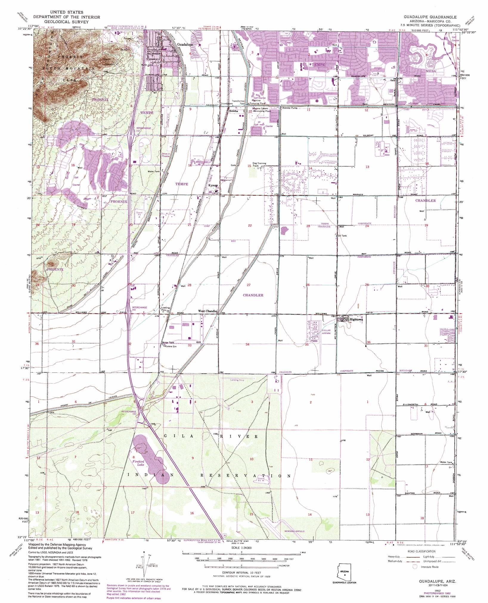
Guadalupe Topo Map Arizona
To zoom in, hover over the map of Guadalupe
USGS Topo Quad 33111c8 - 1:24,000 scale
| Topo Map Name: | Guadalupe |
| USGS Topo Quad ID: | 33111c8 |
| Print Size: | ca. 21 1/4" wide x 27" high |
| Southeast Coordinates: | 33.25° N latitude / 111.875° W longitude |
| Map Center Coordinates: | 33.3125° N latitude / 111.9375° W longitude |
| U.S. State: | AZ |
| Filename: | o33111c8.jpg |
| Download Map JPG Image: | Guadalupe topo map 1:24,000 scale |
| Map Type: | Topographic |
| Topo Series: | 7.5´ |
| Map Scale: | 1:24,000 |
| Source of Map Images: | United States Geological Survey (USGS) |
| Alternate Map Versions: |
Guadalupe AZ 1952, updated 1957 Download PDF Buy paper map Guadalupe AZ 1952, updated 1962 Download PDF Buy paper map Guadalupe AZ 1952, updated 1968 Download PDF Buy paper map Guadalupe AZ 1952, updated 1975 Download PDF Buy paper map Guadalupe AZ 1952, updated 1983 Download PDF Buy paper map Guadalupe AZ 1952, updated 1991 Download PDF Buy paper map Guadalupe AZ 1971, updated 1972 Download PDF Buy paper map Guadalupe AZ 2011 Download PDF Buy paper map Guadalupe AZ 2014 Download PDF Buy paper map |
1:24,000 Topo Quads surrounding Guadalupe
Glendale |
Sunnyslope |
Paradise Valley |
Sawik Mountain |
Granite Reef Dam |
Fowler |
Phoenix |
Tempe |
Mesa |
Buckhorn |
Laveen |
Lone Butte |
Guadalupe |
Chandler |
Higley |
Montezuma Peak |
Pima Butte |
Gila Butte Nw |
Gila Butte |
Chandler Heights |
Enid |
Maricopa |
Sacaton Butte |
Gila Butte Se |
Sacaton |
> Back to 33111a1 at 1:100,000 scale
> Back to 33110a1 at 1:250,000 scale
> Back to U.S. Topo Maps home
Guadalupe topo map: Gazetteer
Guadalupe: Airports
Brenteson Wholesale Incorporated Airport elevation 364m 1194′Sanders Airport elevation 376m 1233′
Stellar Airpark elevation 358m 1174′
Guadalupe: Canals
Kyrene Branch Canal elevation 360m 1181′North Branch Highline Canal elevation 372m 1220′
South Branch Highland Canal elevation 372m 1220′
South Highline Lateral Canal elevation 373m 1223′
Guadalupe: Crossings
Interchange 158 elevation 378m 1240′Interchange 159 elevation 371m 1217′
Interchange 161 elevation 358m 1174′
Interchange 164 elevation 353m 1158′
Interchange One Hundred Fifty Seven elevation 383m 1256′
Interchange One Hundred Sixty elevation 362m 1187′
Interchange One Hundred Sixty Two elevation 351m 1151′
Guadalupe: Dams
Guadalupe Dam elevation 386m 1266′Guadalupe: Lakes
Firebird Lake elevation 350m 1148′Guadalupe: Parks
Biehn Colony Park elevation 377m 1236′Cesela Park elevation 367m 1204′
Corbell Park elevation 361m 1184′
Kiwanis Park elevation 363m 1190′
Knoll East Subdivision Mini Park elevation 366m 1200′
Redden Park elevation 362m 1187′
Sudder Park elevation 363m 1190′
Guadalupe: Populated Places
Ahwatukee elevation 391m 1282′Alta Mira elevation 361m 1184′
Burgundy Hill elevation 402m 1318′
Cambridge Heights elevation 397m 1302′
Camelot Luxury Homes elevation 362m 1187′
Canyon Run elevation 364m 1194′
Central Ridge elevation 364m 1194′
Continental Tempe elevation 362m 1187′
Corona Village elevation 358m 1174′
Crestview elevation 356m 1167′
Desert Villas elevation 388m 1272′
Dusk File elevation 361m 1184′
Estates La Colina elevation 362m 1187′
Glenview Estates elevation 358m 1174′
Guadalupe elevation 376m 1233′
Heatherbrook elevation 364m 1194′
Helena elevation 365m 1197′
Hightown elevation 363m 1190′
Kyrene elevation 363m 1190′
Los Tesoros elevation 360m 1181′
Orangetree elevation 362m 1187′
Parkside elevation 398m 1305′
Pepperwood elevation 361m 1184′
Prado del Sol elevation 358m 1174′
Raintree elevation 361m 1184′
Raintree Luxury Homes elevation 359m 1177′
Renaissance elevation 361m 1184′
Silvergate Trails elevation 365m 1197′
Suncrest Villas Chandler elevation 356m 1167′
Tempe Royal Palms elevation 362m 1187′
The Home Place elevation 365m 1197′
The Lakes elevation 363m 1190′
The Landings elevation 363m 1190′
The Pointe at South Mountain elevation 374m 1227′
Tiburon elevation 363m 1190′
Village of Gila Springs elevation 357m 1171′
West Chandler elevation 356m 1167′
Guadalupe: Post Offices
Ahwatukee Post Office elevation 385m 1263′Chandler Andersen Springs Post Office elevation 366m 1200′
Tempe South Station Post Office elevation 374m 1227′
Guadalupe: Reservoirs
Knoll East Subdivision Water Retention Basin elevation 366m 1200′Guadalupe: Valleys
Dry Wash elevation 350m 1148′Guadalupe digital topo map on disk
Buy this Guadalupe topo map showing relief, roads, GPS coordinates and other geographical features, as a high-resolution digital map file on DVD: