Flint Hill Topo Map South Carolina
To zoom in, hover over the map of Flint Hill
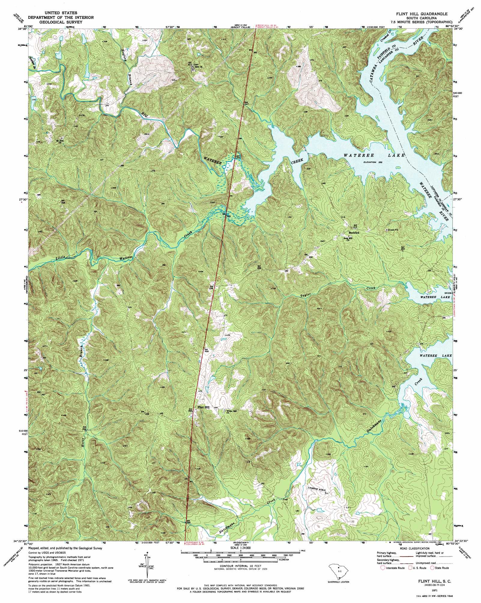
USGS Topo Quad 34080d8 - 1:24,000 scale
| Topo Map Name: | Flint Hill |
| USGS Topo Quad ID: | 34080d8 |
| Print Size: | ca. 21 1/4" wide x 27" high |
| Southeast Coordinates: | 34.375° N latitude / 80.875° W longitude |
| Map Center Coordinates: | 34.4375° N latitude / 80.9375° W longitude |
| U.S. State: | SC |
| Filename: | o34080d8.jpg |
| Download Map JPG Image: | Flint Hill topo map 1:24,000 scale |
| Map Type: | Topographic |
| Topo Series: | 7.5´ |
| Map Scale: | 1:24,000 |
| Source of Map Images: | United States Geological Survey (USGS) |
| Alternate Map Versions: |
Flint Hill SC 1971, updated 1972 Download PDF Buy paper map Flint Hill SC 1971, updated 1987 Download PDF Buy paper map Flint Hill SC 2011 Download PDF Buy paper map Flint Hill SC 2014 Download PDF Buy paper map |
1:24,000 Topo Quads surrounding Flint Hill
Chester |
Richburg |
Fort Lawn |
Lancaster |
Antioch |
Blackstock |
Stover |
Great Falls |
Lancaster Se |
Heath Springs |
Lebanon |
Winnsboro |
Flint Hill |
Liberty Hill |
Whiteoak Creek |
Rion |
Winnsboro Mills |
Ridgeway |
Longtown |
Rabon Crossroads |
Richtex |
Irmo Ne |
Blythewood |
Elgin |
Lugoff |
> Back to 34080a1 at 1:100,000 scale
> Back to 34080a1 at 1:250,000 scale
> Back to U.S. Topo Maps home
Flint Hill topo map: Gazetteer
Flint Hill: Crossings
Dukes Ford (historical) elevation 68m 223′Interchange 41 elevation 131m 429′
Interchange 46 elevation 124m 406′
Flint Hill: Dams
Caughmans Duck Pond D-1572 Dam elevation 95m 311′Flint Hill: Islands
Montgomerys Island (historical) elevation 68m 223′Flint Hill: Populated Places
Biddle (historical) elevation 70m 229′Bucklick elevation 97m 318′
Dutchman Creek elevation 71m 232′
Flint Hill elevation 150m 492′
Taylors Creek elevation 82m 269′
Flint Hill: Rapids
Aldrichs Shoal (historical) elevation 68m 223′Flint Hill: Streams
Big Wateree Creek elevation 68m 223′Catawba River elevation 69m 226′
Crooked Creek elevation 69m 226′
Hogfork Branch elevation 76m 249′
Horse Branch elevation 74m 242′
Little Wateree Creek elevation 69m 226′
Scabbler Branch elevation 82m 269′
Flint Hill digital topo map on disk
Buy this Flint Hill topo map showing relief, roads, GPS coordinates and other geographical features, as a high-resolution digital map file on DVD:
South Carolina, Western North Carolina & Northeastern Georgia
Buy digital topo maps: South Carolina, Western North Carolina & Northeastern Georgia