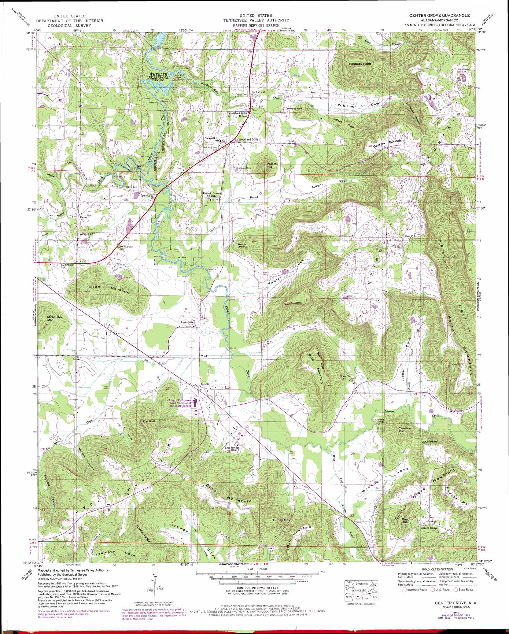
Center Grove Topo Map Alabama
To zoom in, hover over the map of Center Grove
USGS Topo Quad 34086d6 - 1:24,000 scale
| Topo Map Name: | Center Grove |
| USGS Topo Quad ID: | 34086d6 |
| Print Size: | ca. 21 1/4" wide x 27" high |
| Southeast Coordinates: | 34.375° N latitude / 86.625° W longitude |
| Map Center Coordinates: | 34.4375° N latitude / 86.6875° W longitude |
| U.S. State: | AL |
| Filename: | o34086d6.jpg |
| Download Map JPG Image: | Center Grove topo map 1:24,000 scale |
| Map Type: | Topographic |
| Topo Series: | 7.5´ |
| Map Scale: | 1:24,000 |
| Source of Map Images: | United States Geological Survey (USGS) |
| Alternate Map Versions: |
Center Grove AL 1936 Download PDF Buy paper map Center Grove AL 1947, updated 1977 Download PDF Buy paper map Center Grove AL 1947, updated 1983 Download PDF Buy paper map Center Grove AL 1947, updated 1983 Download PDF Buy paper map Center Grove AL 1950, updated 1950 Download PDF Buy paper map Center Grove AL 2011 Download PDF Buy paper map Center Grove AL 2014 Download PDF Buy paper map |
1:24,000 Topo Quads surrounding Center Grove
Tanner |
Greenbrier |
Madison |
Huntsville |
Moontown |
Decatur |
Mason Ridge |
Triana |
Farley |
New Hope |
Hartselle |
Somerville |
Center Grove |
Newsome Sinks |
Guntersville Dam |
Falkville |
Eva |
Lawrence Cove |
Hulaco |
Arab |
West Point |
Cullman |
Simcoe |
Holly Pond |
Brooksville |
> Back to 34086a1 at 1:100,000 scale
> Back to 34086a1 at 1:250,000 scale
> Back to U.S. Topo Maps home
Center Grove topo map: Gazetteer
Center Grove: Airports
Milton-Otto Field elevation 193m 633′Center Grove: Bridges
Crawford Bridge elevation 174m 570′Center Grove: Capes
Carver Point elevation 282m 925′Fort Bluff elevation 322m 1056′
Center Grove: Cliffs
Bee Bluff elevation 319m 1046′Yellow Bluff elevation 314m 1030′
Center Grove: Populated Places
Center Grove elevation 244m 800′Florette elevation 179m 587′
Lynntown elevation 181m 593′
Peach Grove (historical) elevation 177m 580′
Union elevation 184m 603′
West Point elevation 372m 1220′
Woodland Mills elevation 190m 623′
Center Grove: Post Offices
Fort Bluff Post Office (historical) elevation 183m 600′Center Grove: Ranges
Brindley Mountain elevation 403m 1322′Center Grove: Ridges
Cedar Ridge elevation 232m 761′Narrow Ridge elevation 321m 1053′
Center Grove: Springs
Beaver Spring elevation 189m 620′Blowing Spring elevation 200m 656′
Cove Spring Number 1 elevation 184m 603′
Cove Spring Number 2 elevation 204m 669′
Crawford Spring Number 1 elevation 190m 623′
Crawford Spring Number 2 elevation 198m 649′
Crawford Spring Number 3 elevation 246m 807′
Cryer Spring elevation 341m 1118′
Flack Spring elevation 254m 833′
Fowler Spring elevation 190m 623′
Greasy Cove Spring elevation 246m 807′
Guyer Spring elevation 186m 610′
Jaquess Spring elevation 206m 675′
Miller Spring elevation 320m 1049′
Peck Mountain Spring elevation 282m 925′
Peck Spring elevation 189m 620′
Russell Spring elevation 180m 590′
Turney Spring elevation 214m 702′
Williams Cove Spring elevation 208m 682′
Center Grove: Streams
Guyer Branch elevation 171m 561′Jordan Branch elevation 176m 577′
Rocky Branch elevation 171m 561′
Six Mile Creek elevation 171m 561′
Town Creek elevation 171m 561′
West Fork Cotaco Creek elevation 174m 570′
Woodland Mills Creek elevation 170m 557′
Center Grove: Summits
Bean Mountain elevation 297m 974′Center Grove Mountain elevation 329m 1079′
Crawford Point elevation 289m 948′
Doss Mountain elevation 330m 1082′
Fowler Mountain elevation 328m 1076′
Georgia Mountain elevation 377m 1236′
Gurley Mountain elevation 323m 1059′
Kennedy Point elevation 370m 1213′
Little Mountain elevation 246m 807′
McAllister Mountain elevation 282m 925′
Morrow Mountain elevation 347m 1138′
Murphy Mountain elevation 235m 770′
Pate Mountain elevation 348m 1141′
Peck Mountain elevation 356m 1167′
Potato Hill elevation 274m 898′
Roach Back elevation 314m 1030′
Tarkiln Mountain elevation 325m 1066′
Wilson Point elevation 252m 826′
Center Grove: Valleys
Fowler Cove elevation 171m 561′Guyer Cove elevation 180m 590′
Jackson Cove elevation 176m 577′
Johnson Hollow elevation 183m 600′
Morrow Hollow elevation 184m 603′
Peck Hollow elevation 180m 590′
Stillhouse Hollow elevation 205m 672′
Widener Cove elevation 176m 577′
Williams Cove elevation 191m 626′
Center Grove digital topo map on disk
Buy this Center Grove topo map showing relief, roads, GPS coordinates and other geographical features, as a high-resolution digital map file on DVD: