Cullman Topo Map Alabama
To zoom in, hover over the map of Cullman
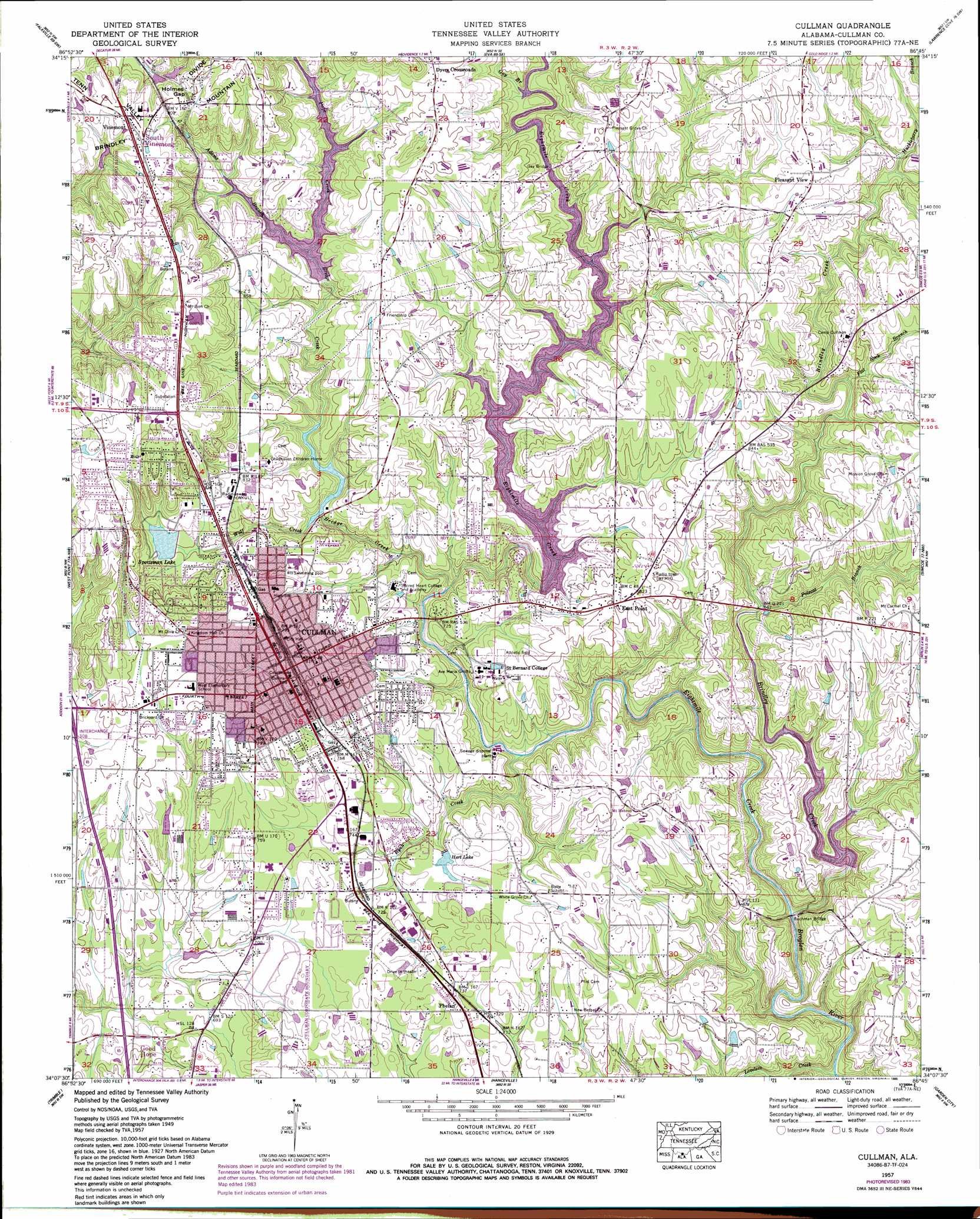
USGS Topo Quad 34086b7 - 1:24,000 scale
| Topo Map Name: | Cullman |
| USGS Topo Quad ID: | 34086b7 |
| Print Size: | ca. 21 1/4" wide x 27" high |
| Southeast Coordinates: | 34.125° N latitude / 86.75° W longitude |
| Map Center Coordinates: | 34.1875° N latitude / 86.8125° W longitude |
| U.S. State: | AL |
| Filename: | o34086b7.jpg |
| Download Map JPG Image: | Cullman topo map 1:24,000 scale |
| Map Type: | Topographic |
| Topo Series: | 7.5´ |
| Map Scale: | 1:24,000 |
| Source of Map Images: | United States Geological Survey (USGS) |
| Alternate Map Versions: |
Cullman AL 1957, updated 1960 Download PDF Buy paper map Cullman AL 1957, updated 1968 Download PDF Buy paper map Cullman AL 1957, updated 1970 Download PDF Buy paper map Cullman AL 1957, updated 1985 Download PDF Buy paper map Cullman AL 1957, updated 1985 Download PDF Buy paper map Cullman AL 2011 Download PDF Buy paper map Cullman AL 2014 Download PDF Buy paper map |
| FStopo: | US Forest Service topo Cullman is available: Download FStopo PDF Download FStopo TIF |
1:24,000 Topo Quads surrounding Cullman
Danville |
Hartselle |
Somerville |
Center Grove |
Newsome Sinks |
Massey |
Falkville |
Eva |
Lawrence Cove |
Hulaco |
Jones Chapel |
West Point |
Cullman |
Simcoe |
Holly Pond |
Crane Hill |
Trimble |
Hanceville |
Garden City |
Blountsville |
Cold Springs |
Arkadelphia |
Blount Springs |
Nectar |
Cleveland |
> Back to 34086a1 at 1:100,000 scale
> Back to 34086a1 at 1:250,000 scale
> Back to U.S. Topo Maps home
Cullman topo map: Gazetteer
Cullman: Bridges
Buchman Bridge elevation 165m 541′Gay Bridge elevation 230m 754′
Cullman: Dams
Carl Budweg Dam elevation 243m 797′Eva Road Lake Dam elevation 216m 708′
Forrest Ingram Dam elevation 194m 636′
L B Hayes Dam elevation 293m 961′
Lake Catoma Dam elevation 235m 770′
Lake George Dam elevation 248m 813′
Lee Hart Dam elevation 214m 702′
Sportsman Lake Dam elevation 249m 816′
Cullman: Gaps
Holmes Gap elevation 286m 938′Cullman: Parks
Carrol Acres Park elevation 224m 734′Cullman County Fairgrounds elevation 250m 820′
Cullman Downtown Commercial Historic District elevation 250m 820′
Cullman Historic District elevation 243m 797′
East Side Park elevation 233m 764′
Main Avenue Park elevation 235m 770′
Margaret Engle Park elevation 239m 784′
Nesmith Park elevation 244m 800′
Northwood Park elevation 295m 967′
Terrace Heights Park elevation 298m 977′
Cullman: Populated Places
Bolte elevation 226m 741′Carrol Acres elevation 220m 721′
Cullman elevation 242m 793′
Dyers Crossroads elevation 280m 918′
East Point elevation 247m 810′
Northwood elevation 300m 984′
Phelan elevation 227m 744′
Pleasant View elevation 268m 879′
Smithdale elevation 291m 954′
South Vinemont elevation 299m 980′
Terrace Heights elevation 299m 980′
Vinemont elevation 298m 977′
Cullman: Post Offices
Cullman Post Office elevation 249m 816′Vinemont Post Office elevation 301m 987′
Cullman: Reservoirs
Davis Lake elevation 243m 797′Eva Road Lake elevation 216m 708′
Forest Ingram Lake elevation 194m 636′
George Lake elevation 248m 813′
Hart Lake elevation 213m 698′
Hayes Lake elevation 293m 961′
Lake Catoma elevation 235m 770′
Sportman Lake elevation 244m 800′
Cullman: Streams
Adams Branch elevation 248m 813′Bridge Creek elevation 200m 656′
Brindley Creek elevation 165m 541′
Eightmile Creek elevation 165m 541′
Flat Rock Branch elevation 217m 711′
Gay Branch elevation 228m 748′
Huckleberry Branch elevation 232m 761′
Loveless Creek elevation 164m 538′
Polecat Branch elevation 205m 672′
Pope Creek elevation 248m 813′
Ryan Creek elevation 190m 623′
Wolf Creek elevation 214m 702′
Cullman digital topo map on disk
Buy this Cullman topo map showing relief, roads, GPS coordinates and other geographical features, as a high-resolution digital map file on DVD: