Hartselle Topo Map Alabama
To zoom in, hover over the map of Hartselle
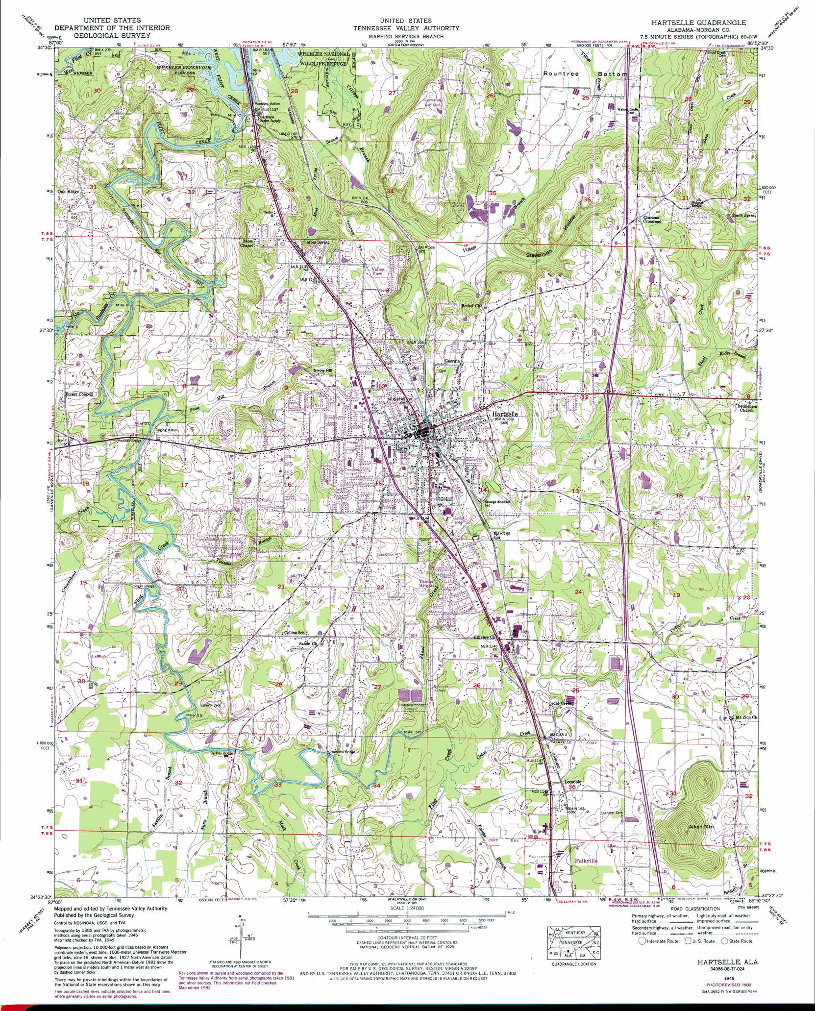
USGS Topo Quad 34086d8 - 1:24,000 scale
| Topo Map Name: | Hartselle |
| USGS Topo Quad ID: | 34086d8 |
| Print Size: | ca. 21 1/4" wide x 27" high |
| Southeast Coordinates: | 34.375° N latitude / 86.875° W longitude |
| Map Center Coordinates: | 34.4375° N latitude / 86.9375° W longitude |
| U.S. State: | AL |
| Filename: | o34086d8.jpg |
| Download Map JPG Image: | Hartselle topo map 1:24,000 scale |
| Map Type: | Topographic |
| Topo Series: | 7.5´ |
| Map Scale: | 1:24,000 |
| Source of Map Images: | United States Geological Survey (USGS) |
| Alternate Map Versions: |
Hartselle AL 1936 Download PDF Buy paper map Hartselle AL 1949, updated 1970 Download PDF Buy paper map Hartselle AL 1949, updated 1983 Download PDF Buy paper map Hartselle AL 1951, updated 1951 Download PDF Buy paper map Hartselle AL 2011 Download PDF Buy paper map Hartselle AL 2014 Download PDF Buy paper map |
| FStopo: | US Forest Service topo Hartselle is available: Download FStopo PDF Download FStopo TIF |
1:24,000 Topo Quads surrounding Hartselle
Hillsboro |
Jones Crossroads |
Tanner |
Greenbrier |
Madison |
Caddo |
Trinity |
Decatur |
Mason Ridge |
Triana |
Oakville |
Danville |
Hartselle |
Somerville |
Center Grove |
Upshaw |
Massey |
Falkville |
Eva |
Lawrence Cove |
Addison |
Jones Chapel |
West Point |
Cullman |
Simcoe |
> Back to 34086a1 at 1:100,000 scale
> Back to 34086a1 at 1:250,000 scale
> Back to U.S. Topo Maps home
Hartselle topo map: Gazetteer
Hartselle: Airports
Rountree Field elevation 186m 610′Hartselle: Arches
Hartselle Natural Bridge elevation 227m 744′Hartselle: Bends
Rountree Bottom elevation 186m 610′Hartselle: Bridges
Barkley Bridge elevation 173m 567′Huckaba Bridge elevation 173m 567′
Nance Ford Bridge elevation 171m 561′
Riggs Bridge elevation 171m 561′
Vaughn Bridge (historical) elevation 170m 557′
Woodall Bridge elevation 170m 557′
Hartselle: Crossings
Interchange 328 elevation 195m 639′Hartselle: Dams
Oak Lane Dam elevation 175m 574′Hartselle: Lakes
Ashworth Pond (historical) elevation 193m 633′Hartselle: Parks
Tiger Stadium elevation 199m 652′Hartselle: Populated Places
Clemons Crossroad elevation 228m 748′Georgia elevation 212m 695′
Hartselle elevation 205m 672′
Leesdale elevation 184m 603′
Oak Ridge elevation 201m 659′
Tanner Heights elevation 189m 620′
Valley View elevation 227m 744′
Hartselle: Post Offices
Hartselle Post Office elevation 205m 672′Hartselle: Reservoirs
Roberts Lake elevation 175m 574′Hartselle: Springs
Moss Spring elevation 214m 702′Smith Spring elevation 201m 659′
Snow Spring elevation 184m 603′
Hartselle: Streams
Cedar Creek elevation 174m 570′Crowdabout Creek elevation 170m 557′
Mack Creek elevation 173m 567′
McCutcheon Creek elevation 183m 600′
Moss Spring Branch elevation 171m 561′
No Business Creek elevation 170m 557′
Nunn Branch elevation 172m 564′
Outlaw Spring Branch elevation 185m 606′
Painter Branch elevation 175m 574′
Rocky Branch elevation 198m 649′
Sandlin Branch elevation 172m 564′
Shoal Creek elevation 174m 570′
Sleighton Branch elevation 198m 649′
Snow Hill Branch elevation 170m 557′
Town Branch elevation 189m 620′
Tunselle Branch elevation 171m 561′
West Flint Creek elevation 170m 557′
Hartselle: Summits
Aiken Mountain elevation 295m 967′Snow Hill elevation 201m 659′
Hartselle: Valleys
Stevenson Hollow elevation 177m 580′Hartselle: Wells
Burnetts Salt Well (historical) elevation 189m 620′Hartselle digital topo map on disk
Buy this Hartselle topo map showing relief, roads, GPS coordinates and other geographical features, as a high-resolution digital map file on DVD: