Cairo Topo Map Alabama
To zoom in, hover over the map of Cairo
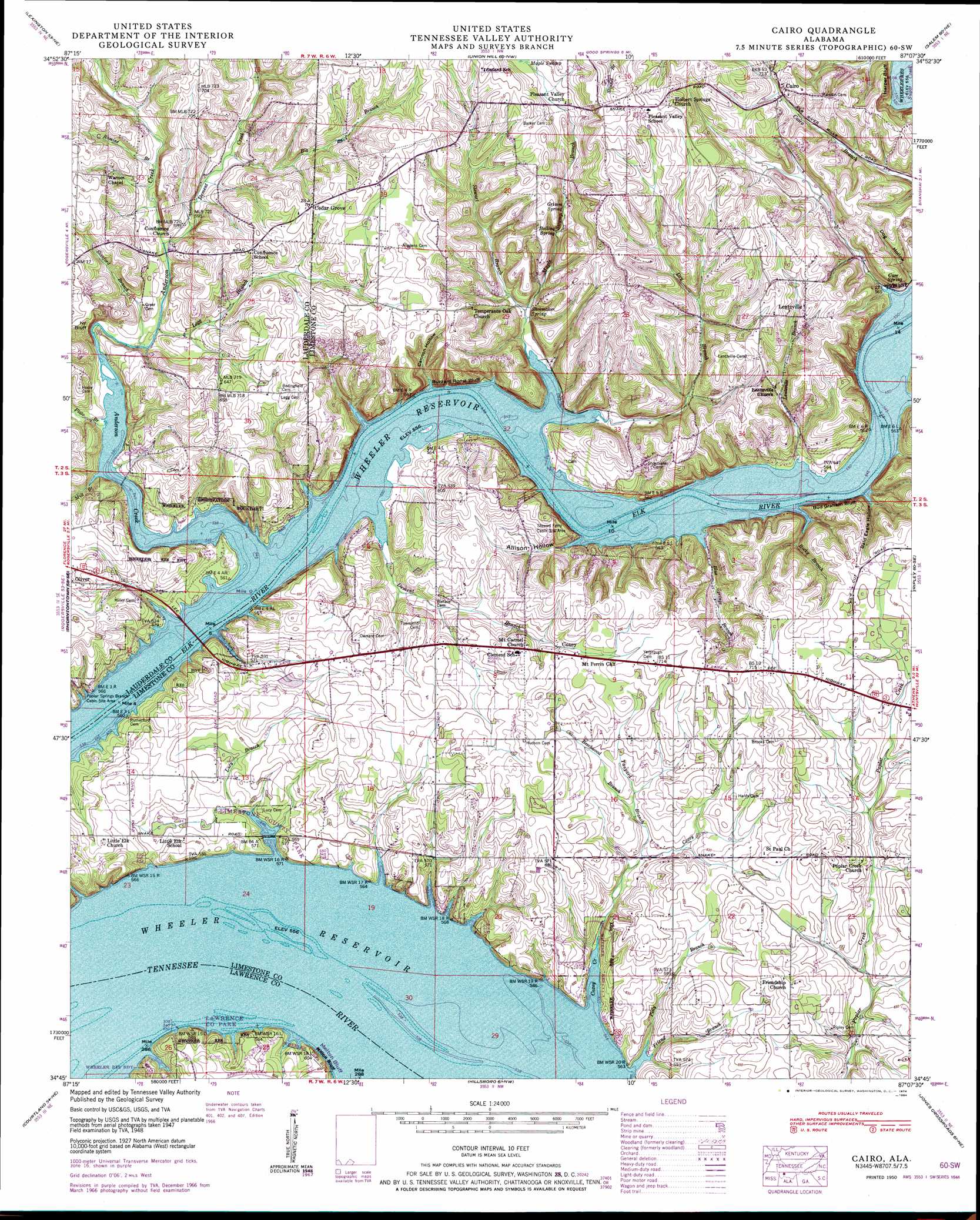
USGS Topo Quad 34087g2 - 1:24,000 scale
| Topo Map Name: | Cairo |
| USGS Topo Quad ID: | 34087g2 |
| Print Size: | ca. 21 1/4" wide x 27" high |
| Southeast Coordinates: | 34.75° N latitude / 87.125° W longitude |
| Map Center Coordinates: | 34.8125° N latitude / 87.1875° W longitude |
| U.S. State: | AL |
| Filename: | o34087g2.jpg |
| Download Map JPG Image: | Cairo topo map 1:24,000 scale |
| Map Type: | Topographic |
| Topo Series: | 7.5´ |
| Map Scale: | 1:24,000 |
| Source of Map Images: | United States Geological Survey (USGS) |
| Alternate Map Versions: |
Cairo AL 1936 Download PDF Buy paper map Cairo AL 1950 Download PDF Buy paper map Cairo AL 1950, updated 1974 Download PDF Buy paper map Cairo AL 1950, updated 1984 Download PDF Buy paper map Cairo AL 2011 Download PDF Buy paper map Cairo AL 2014 Download PDF Buy paper map |
1:24,000 Topo Quads surrounding Cairo
Loretto |
Bonnertown |
Appleton |
Aspen Hill |
Elkton |
Center Hill |
Lexington |
Union Hill |
Salem |
Elkmont |
Wheeler Dam |
Rogersville |
Cairo |
Ripley |
Athens |
Town Creek |
Courtland |
Hillsboro |
Jones Crossroads |
Tanner |
Hatton |
Masterson |
Caddo |
Trinity |
Decatur |
> Back to 34087e1 at 1:100,000 scale
> Back to 34086a1 at 1:250,000 scale
> Back to U.S. Topo Maps home
Cairo topo map: Gazetteer
Cairo: Bars
Gilchrist Bar (historical) elevation 170m 557′Cairo: Cliffs
Bud Graham Bluff elevation 173m 567′Buzzard Roost Bluff elevation 170m 557′
Harper Bluff elevation 177m 580′
Ivy Bluff elevation 176m 577′
Melton Bluff elevation 174m 570′
Cairo: Crossings
Bedingfield Ferry (historical) elevation 170m 557′Cairo: Islands
Chigger Island (historical) elevation 170m 557′Cairo: Parks
Elk River Lodge State Park elevation 174m 570′Lawrence County Park elevation 184m 603′
Limestone County Park elevation 170m 557′
Cairo: Populated Places
Anderson Creek Estates elevation 183m 600′Anderson Creek Subdivision elevation 173m 567′
Beechwood Acres elevation 176m 577′
Blue Springs Park elevation 193m 633′
Cairo elevation 206m 675′
Cave Spring elevation 201m 659′
Cedar Grove elevation 220m 721′
Confluence elevation 177m 580′
Coxey elevation 204m 669′
Coxey Creek Subdivision elevation 181m 593′
Dogwood elevation 182m 597′
Elk Estates elevation 184m 603′
Elk Shores elevation 183m 600′
Lazy Living Acres elevation 175m 574′
Lentzville elevation 219m 718′
Pleasant Grove elevation 241m 790′
Shoemaker Springs (historical) elevation 174m 570′
Cairo: Post Offices
Lucky Hit Post Office (historical) elevation 186m 610′Shoalford Post Office (historical) elevation 179m 587′
Cairo: Springs
Boiling Spring elevation 201m 659′Cave Spring elevation 170m 557′
Grimm Spring elevation 202m 662′
Shoemaker Spring elevation 175m 574′
Cairo: Streams
Anderson Creek elevation 170m 557′Beechwood Branch elevation 187m 613′
Big Branch elevation 176m 577′
Blue Springs Branch elevation 171m 561′
Coxey Creek elevation 170m 557′
Dement Branch elevation 170m 557′
Dement Creek elevation 173m 567′
Dry Branch elevation 170m 557′
Friend Branch elevation 170m 557′
Hamilton Spring Branch elevation 180m 590′
Legg Branch elevation 173m 567′
Lentzville Branch elevation 170m 557′
Lucy Branch elevation 170m 557′
Maple Swamp Branch elevation 170m 557′
Mill Branch elevation 170m 557′
Petty Branch elevation 170m 557′
Plato Branch elevation 172m 564′
Rocky Branch elevation 172m 564′
Romine Branch elevation 174m 570′
Stanford Branch elevation 173m 567′
Stewart Branch elevation 178m 583′
Tanyard Branch elevation 178m 583′
Cairo: Valleys
Allison Hollow elevation 170m 557′Bald Eagle Hollow elevation 170m 557′
Cannon Hollow elevation 170m 557′
Dog Hollow elevation 171m 561′
Owl Hollow elevation 174m 570′
Cairo digital topo map on disk
Buy this Cairo topo map showing relief, roads, GPS coordinates and other geographical features, as a high-resolution digital map file on DVD: