Chavez Mountain East Topo Map Arizona
To zoom in, hover over the map of Chavez Mountain East
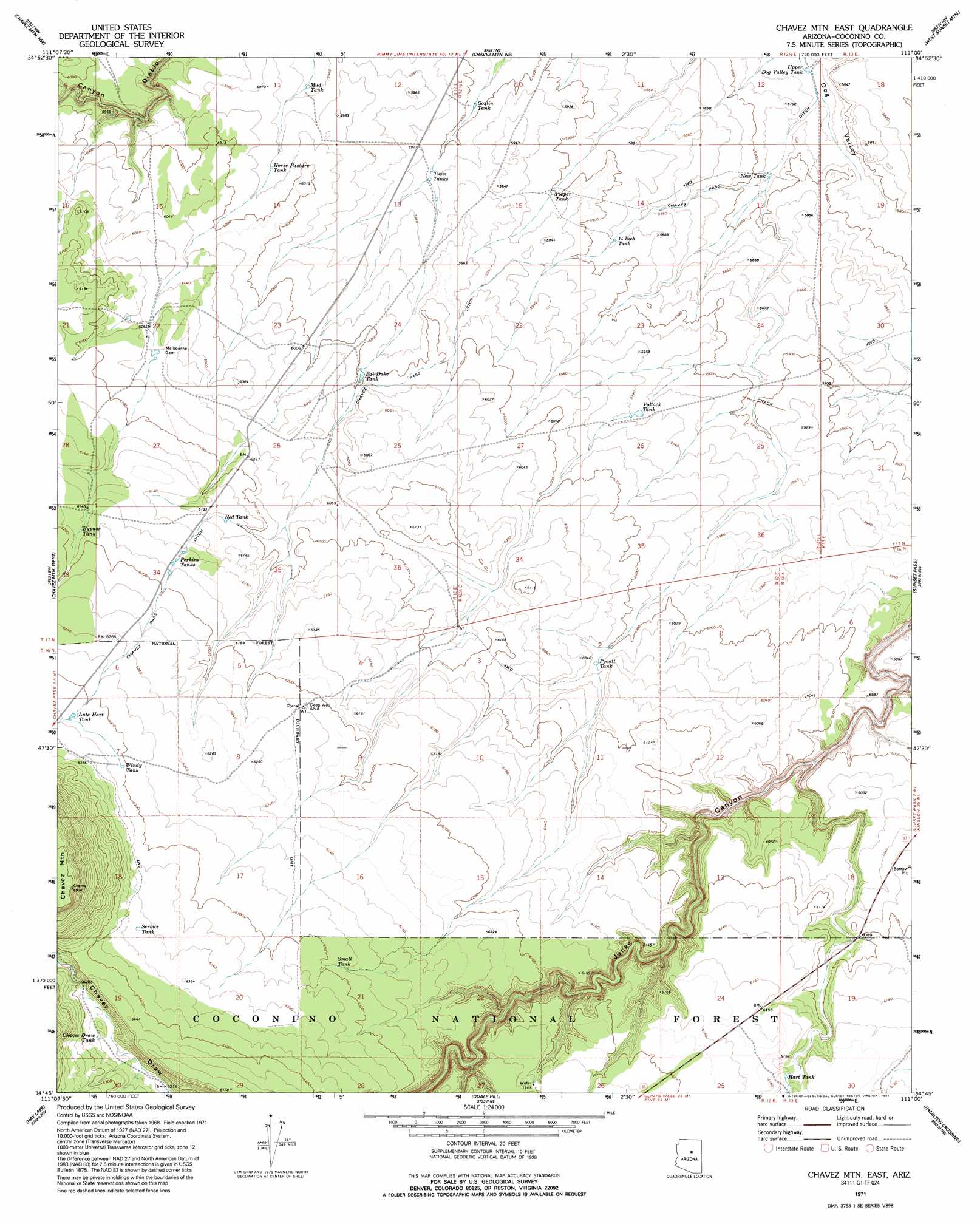
USGS Topo Quad 34111g1 - 1:24,000 scale
| Topo Map Name: | Chavez Mountain East |
| USGS Topo Quad ID: | 34111g1 |
| Print Size: | ca. 21 1/4" wide x 27" high |
| Southeast Coordinates: | 34.75° N latitude / 111° W longitude |
| Map Center Coordinates: | 34.8125° N latitude / 111.0625° W longitude |
| U.S. State: | AZ |
| Filename: | o34111g1.jpg |
| Download Map JPG Image: | Chavez Mountain East topo map 1:24,000 scale |
| Map Type: | Topographic |
| Topo Series: | 7.5´ |
| Map Scale: | 1:24,000 |
| Source of Map Images: | United States Geological Survey (USGS) |
| Alternate Map Versions: |
Chavez Mtn East AZ 1971, updated 1973 Download PDF Buy paper map Chavez Mtn East AZ 1971, updated 1992 Download PDF Buy paper map Chavez Mountain East AZ 2011 Download PDF Buy paper map Chavez Mountain East AZ 2014 Download PDF Buy paper map |
| FStopo: | US Forest Service topo Chavez Mountain East is available: Download FStopo PDF Download FStopo TIF |
1:24,000 Topo Quads surrounding Chavez Mountain East
Elliott Canyon |
Anderson Canyon |
Meteor Crater |
Tucker Mesa Sw |
Tucker Mesa |
Kinnikinick Lake |
Chavez Mountain Nw |
Chavez Mountain Ne |
West Sunset Mountain |
Rock Station |
Jaycox Mountain |
Chavez Mountain West |
Chavez Mountain East |
Sunset Pass |
Pump Ranch Tank |
Turkey Mountain |
Hay Lake |
Quayle Hill |
Hamilton Crossing |
Chevelon Butte |
Long Valley |
Blue Ridge Reservoir |
Leonard Canyon |
Grama Draw |
Chevelon Crossing |
> Back to 34111e1 at 1:100,000 scale
> Back to 34110a1 at 1:250,000 scale
> Back to U.S. Topo Maps home
Chavez Mountain East topo map: Gazetteer
Chavez Mountain East: Canals
Chavez Pass Ditch elevation 1831m 6007′Chavez Mountain East: Dams
Melbourne Dam elevation 1851m 6072′Chavez Mountain East: Reservoirs
Bypass Tank elevation 1880m 6167′Chavez Draw Tank elevation 1910m 6266′
Fourteen Inch Tank elevation 1793m 5882′
Goslin Tank elevation 1798m 5898′
Hart Tank elevation 1871m 6138′
Horse Pasture Tank elevation 1821m 5974′
Lute Hart Tank elevation 1925m 6315′
Melburn Tank elevation 1851m 6072′
Mud Tank elevation 1810m 5938′
New Tank elevation 1761m 5777′
Pat Duke Tank elevation 1828m 5997′
Perkins Tanks elevation 1879m 6164′
Pieper Tank elevation 1800m 5905′
Pollack Tank elevation 1809m 5935′
Pyeatt Tank elevation 1833m 6013′
Red Tank elevation 1866m 6122′
Service Tank elevation 1936m 6351′
Small Tank elevation 1920m 6299′
Twin Tanks elevation 1803m 5915′
Upper Dog Valley Tank elevation 1754m 5754′
Windy Tank elevation 1923m 6309′
Chavez Mountain East: Summits
Chavez Mountain elevation 2107m 6912′Chavez Mountain East: Wells
Deep Well elevation 1894m 6213′Chavez Mountain East digital topo map on disk
Buy this Chavez Mountain East topo map showing relief, roads, GPS coordinates and other geographical features, as a high-resolution digital map file on DVD: