Grama Draw Topo Map Arizona
To zoom in, hover over the map of Grama Draw
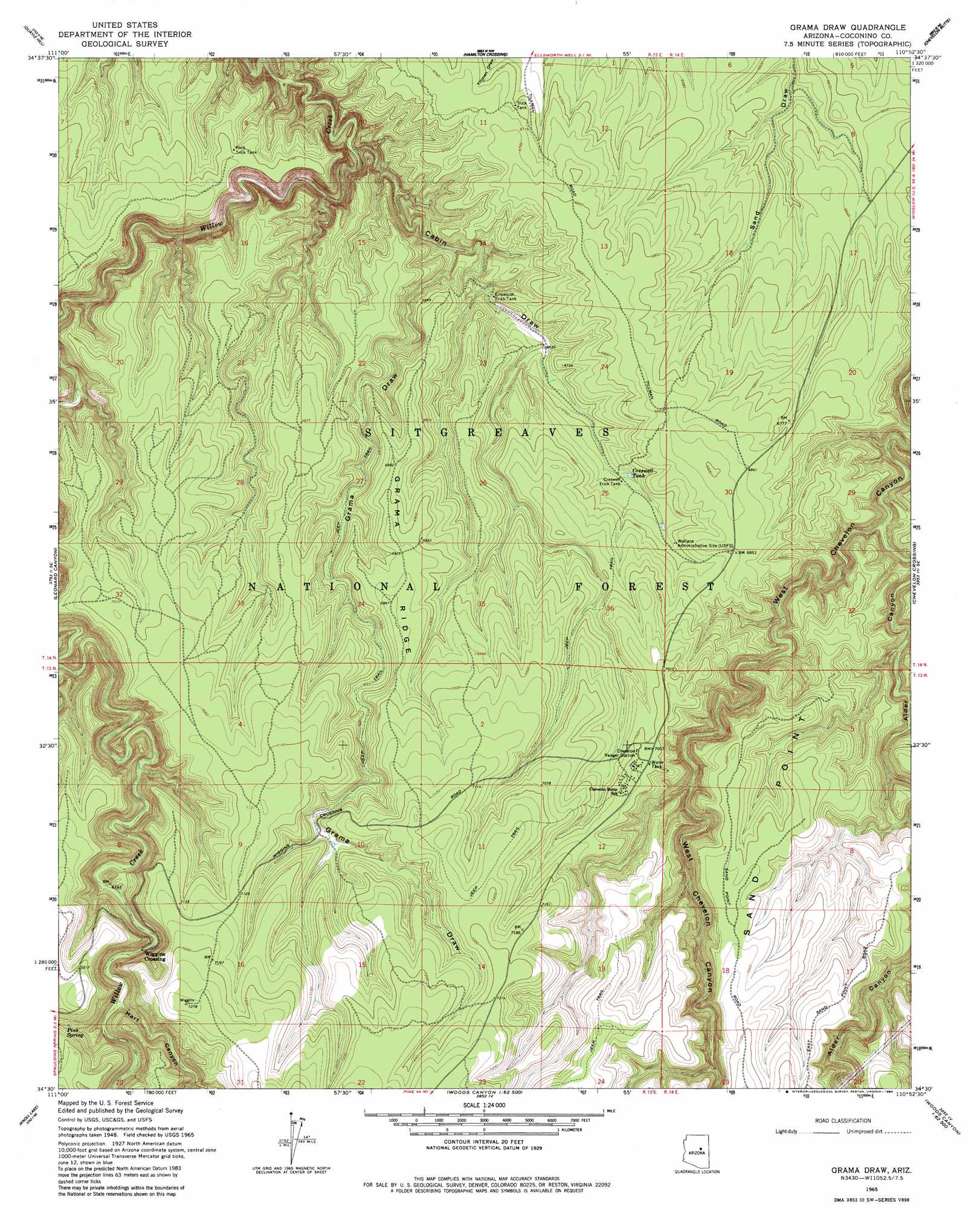
USGS Topo Quad 34110e8 - 1:24,000 scale
| Topo Map Name: | Grama Draw |
| USGS Topo Quad ID: | 34110e8 |
| Print Size: | ca. 21 1/4" wide x 27" high |
| Southeast Coordinates: | 34.5° N latitude / 110.875° W longitude |
| Map Center Coordinates: | 34.5625° N latitude / 110.9375° W longitude |
| U.S. State: | AZ |
| Filename: | o34110e8.jpg |
| Download Map JPG Image: | Grama Draw topo map 1:24,000 scale |
| Map Type: | Topographic |
| Topo Series: | 7.5´ |
| Map Scale: | 1:24,000 |
| Source of Map Images: | United States Geological Survey (USGS) |
| Alternate Map Versions: |
Grama Draw AZ 1965, updated 1967 Download PDF Buy paper map Grama Draw AZ 1965, updated 1984 Download PDF Buy paper map Grama Draw AZ 1965, updated 1984 Download PDF Buy paper map Grama Draw AZ 1998, updated 2000 Download PDF Buy paper map Grama Draw AZ 2011 Download PDF Buy paper map Grama Draw AZ 2014 Download PDF Buy paper map |
| FStopo: | US Forest Service topo Grama Draw is available: Download FStopo PDF Download FStopo TIF |
1:24,000 Topo Quads surrounding Grama Draw
Chavez Mountain West |
Chavez Mountain East |
Sunset Pass |
Pump Ranch Tank |
Twentymile Hill |
Hay Lake |
Quayle Hill |
Hamilton Crossing |
Chevelon Butte |
Potato Wash North |
Blue Ridge Reservoir |
Leonard Canyon |
Grama Draw |
Chevelon Crossing |
Potato Wash South |
Dane Canyon |
Knoll Lake |
Porcupine Ridge |
Weimer Point |
Hanks Draw |
Diamond Point |
Promontory Butte |
Woods Canyon |
O W Point |
Brookbank Point |
> Back to 34110e1 at 1:100,000 scale
> Back to 34110a1 at 1:250,000 scale
> Back to U.S. Topo Maps home
Grama Draw topo map: Gazetteer
Grama Draw: Basins
Tillman Water Catchment elevation 2043m 6702′Grama Draw: Cliffs
Sand Point elevation 2139m 7017′Grama Draw: Populated Places
Wiggins Crossing elevation 2061m 6761′Grama Draw: Reservoirs
Creswell Tank elevation 2048m 6719′Creswell Trick Tank elevation 2051m 6729′
Ellsworth Trick Tank elevation 2004m 6574′
Grama Trick Tank elevation 2183m 7162′
Rock Trick Tank elevation 2043m 6702′
Sand Draw Tank elevation 2037m 6683′
Tillman Trick Tank elevation 2046m 6712′
Tillman Water Catchment elevation 2049m 6722′
Grama Draw: Ridges
Barney Ridge elevation 2140m 7020′Grama Ridge elevation 2113m 6932′
Middle Ridge elevation 2176m 7139′
Grama Draw: Springs
Pius Spring elevation 2149m 7050′Grama Draw: Streams
Alder Creek elevation 1974m 6476′East Fork Willow Creek elevation 1921m 6302′
West Fork Willow Creek elevation 1970m 6463′
Grama Draw: Valleys
Alder Canyon elevation 1974m 6476′Cabin Draw elevation 1885m 6184′
Grama Draw elevation 1982m 6502′
Hart Canyon elevation 2068m 6784′
Willow Creek Canyon elevation 2067m 6781′
Grama Draw: Wells
Tillman Well elevation 2091m 6860′Grama Draw digital topo map on disk
Buy this Grama Draw topo map showing relief, roads, GPS coordinates and other geographical features, as a high-resolution digital map file on DVD: