Tucker Mesa Sw Topo Map Arizona
To zoom in, hover over the map of Tucker Mesa Sw
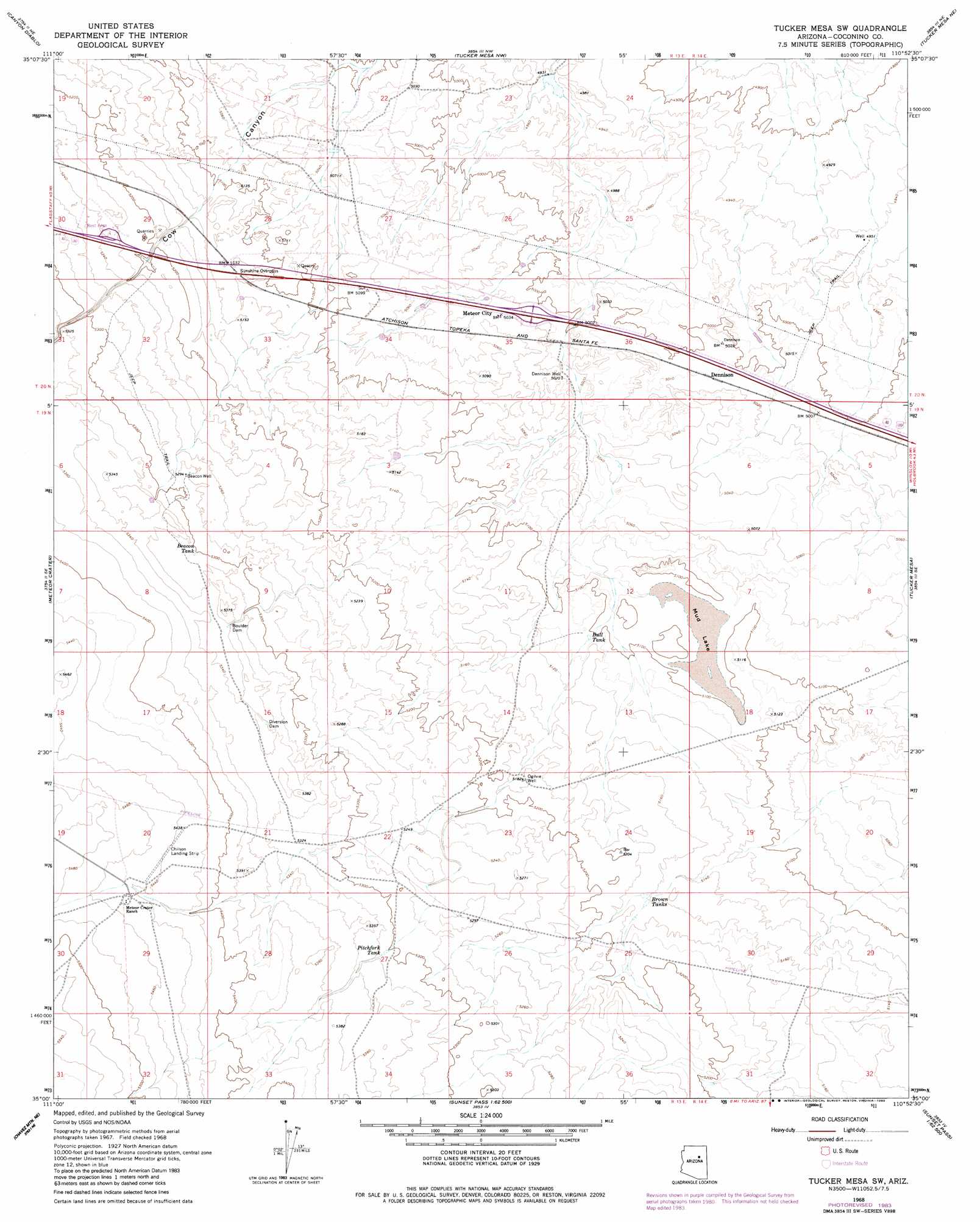
USGS Topo Quad 35110a8 - 1:24,000 scale
| Topo Map Name: | Tucker Mesa Sw |
| USGS Topo Quad ID: | 35110a8 |
| Print Size: | ca. 21 1/4" wide x 27" high |
| Southeast Coordinates: | 35° N latitude / 110.875° W longitude |
| Map Center Coordinates: | 35.0625° N latitude / 110.9375° W longitude |
| U.S. State: | AZ |
| Filename: | o35110a8.jpg |
| Download Map JPG Image: | Tucker Mesa Sw topo map 1:24,000 scale |
| Map Type: | Topographic |
| Topo Series: | 7.5´ |
| Map Scale: | 1:24,000 |
| Source of Map Images: | United States Geological Survey (USGS) |
| Alternate Map Versions: |
Tucker Mesa SW AZ 1968, updated 1973 Download PDF Buy paper map Tucker Mesa SW AZ 1968, updated 1983 Download PDF Buy paper map Tucker Mesa SW AZ 2011 Download PDF Buy paper map Tucker Mesa SW AZ 2014 Download PDF Buy paper map |
1:24,000 Topo Quads surrounding Tucker Mesa Sw
Grand Falls Sw |
Grand Falls Se |
Old Leupp |
East Of Old Leupp |
Bird Springs Wash |
Babbitt Wash |
Canyon Diablo |
Tucker Mesa Nw |
Tucker Mesa Ne |
Winslow Nw |
Anderson Canyon |
Meteor Crater |
Tucker Mesa Sw |
Tucker Mesa |
Winslow |
Chavez Mountain Nw |
Chavez Mountain Ne |
West Sunset Mountain |
Rock Station |
Clear Creek Reservoir |
Chavez Mountain West |
Chavez Mountain East |
Sunset Pass |
Pump Ranch Tank |
Twentymile Hill |
> Back to 35110a1 at 1:100,000 scale
> Back to 35110a1 at 1:250,000 scale
> Back to U.S. Topo Maps home
Tucker Mesa Sw topo map: Gazetteer
Tucker Mesa Sw: Airports
Chilson Landing Strip elevation 1660m 5446′Tucker Mesa Sw: Crossings
Dennison Interchange elevation 1527m 5009′Sunshine Overpass elevation 1566m 5137′
Tucker Mesa Sw: Dams
Boulder Dam elevation 1626m 5334′Tucker Mesa Sw: Lakes
Mud Lake elevation 1554m 5098′Tucker Mesa Sw: Parks
Meteor Crater Rest Area elevation 1594m 5229′Tucker Mesa Sw: Populated Places
Dennison elevation 1528m 5013′Meteor City elevation 1534m 5032′
Tucker Mesa Sw: Reservoirs
Beacon Tank elevation 1617m 5305′Brown Tanks elevation 1574m 5164′
Bull Tank elevation 1556m 5104′
Pitchfork Tank elevation 1617m 5305′
Tucker Mesa Sw: Wells
Beacon Well elevation 1612m 5288′Dennison Well elevation 1532m 5026′
Ogilvie Well elevation 1580m 5183′
Tucker Mesa Sw digital topo map on disk
Buy this Tucker Mesa Sw topo map showing relief, roads, GPS coordinates and other geographical features, as a high-resolution digital map file on DVD: