Big Pine Mountain Topo Map California
To zoom in, hover over the map of Big Pine Mountain
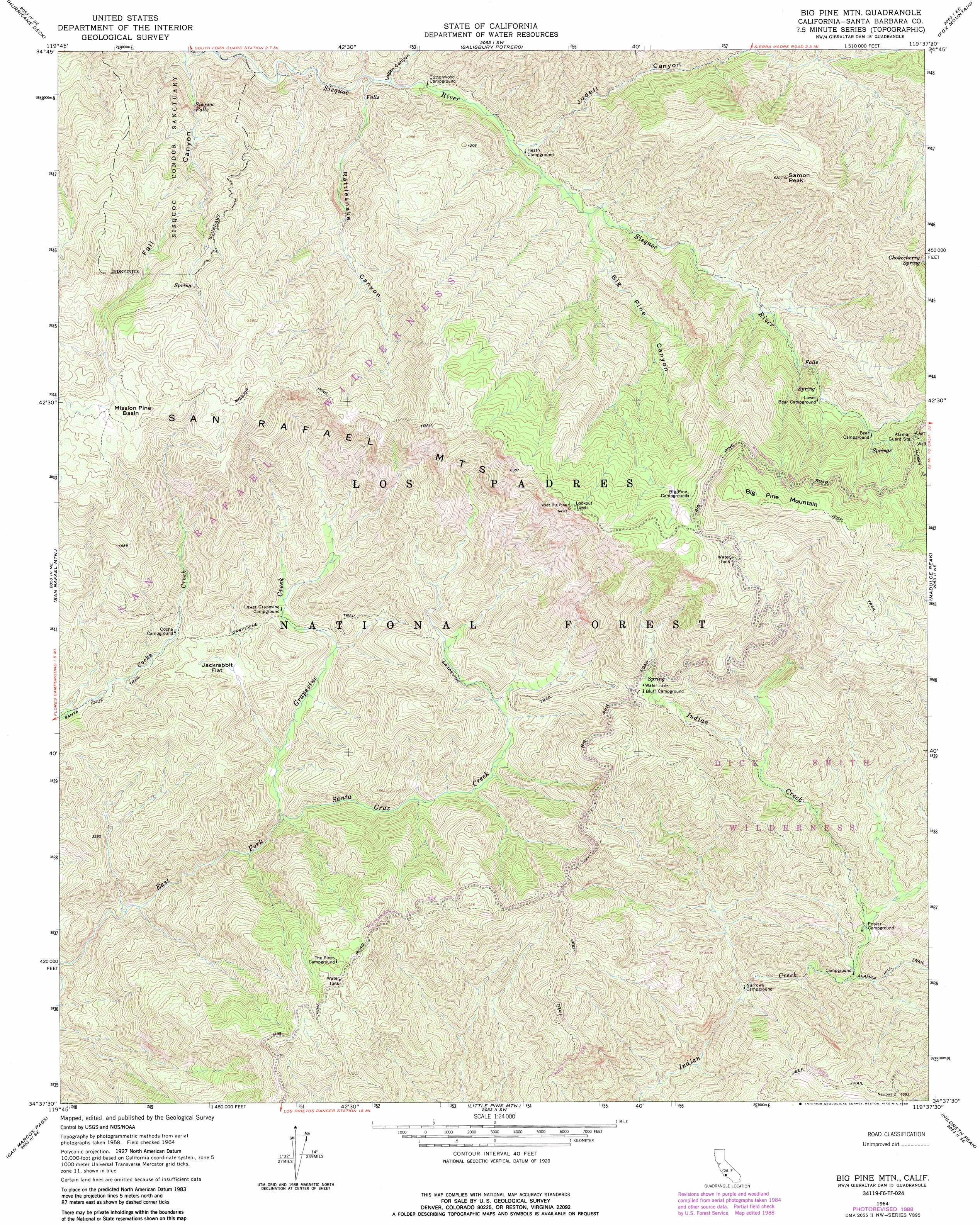
USGS Topo Quad 34119f6 - 1:24,000 scale
| Topo Map Name: | Big Pine Mountain |
| USGS Topo Quad ID: | 34119f6 |
| Print Size: | ca. 21 1/4" wide x 27" high |
| Southeast Coordinates: | 34.625° N latitude / 119.625° W longitude |
| Map Center Coordinates: | 34.6875° N latitude / 119.6875° W longitude |
| U.S. State: | CA |
| Filename: | o34119f6.jpg |
| Download Map JPG Image: | Big Pine Mountain topo map 1:24,000 scale |
| Map Type: | Topographic |
| Topo Series: | 7.5´ |
| Map Scale: | 1:24,000 |
| Source of Map Images: | United States Geological Survey (USGS) |
| Alternate Map Versions: |
Big Pine Mountain CA 1943, updated 1963 Download PDF Buy paper map Big Pine Mtn CA 1964, updated 1965 Download PDF Buy paper map Big Pine Mtn CA 1964, updated 1965 Download PDF Buy paper map Big Pine Mtn CA 1964, updated 1965 Download PDF Buy paper map Big Pine Mtn CA 1964, updated 1989 Download PDF Buy paper map Big Pine Mtn CA 1977 Download PDF Buy paper map Big Pine Mountain CA 1995, updated 2000 Download PDF Buy paper map Big Pine Mountain CA 2012 Download PDF Buy paper map Big Pine Mountain CA 2015 Download PDF Buy paper map |
| FStopo: | US Forest Service topo Big Pine Mountain is available: Download FStopo PDF Download FStopo TIF |
1:24,000 Topo Quads surrounding Big Pine Mountain
Bates Canyon |
Peak Mountain |
New Cuyama |
Cuyama |
Ballinger Canyon |
Bald Mountain |
Hurricane Deck |
Salisbury Potrero |
Fox Mountain |
Cuyama Peak |
Figueroa Mountain |
San Rafael Mountain |
Big Pine Mountain |
Madulce Peak |
Rancho Nuevo Creek |
Lake Cachuma |
San Marcos Pass |
Little Pine Mountain |
Hildreth Peak |
Old Man Mountain |
Dos Pueblos Canyon |
Goleta |
Santa Barbara |
Carpinteria |
White Ledge Peak |
> Back to 34119e1 at 1:100,000 scale
> Back to 34118a1 at 1:250,000 scale
> Back to U.S. Topo Maps home
Big Pine Mountain topo map: Gazetteer
Big Pine Mountain: Basins
Mission Pine Basin elevation 1635m 5364′Big Pine Mountain: Falls
Sisquoc Falls elevation 1109m 3638′Big Pine Mountain: Flats
Jackrabbit Flat elevation 1017m 3336′Big Pine Mountain: Parks
Sisquoc Condor Sanctuary elevation 1233m 4045′Big Pine Mountain: Springs
Chokecherry Spring elevation 1678m 5505′Big Pine Mountain: Streams
Grapevine Creek elevation 913m 2995′Big Pine Mountain: Summits
Big Pine Mountain elevation 2077m 6814′Samon Peak elevation 1840m 6036′
Big Pine Mountain: Trails
Grapevine Trail elevation 1140m 3740′Mission Pine Trail elevation 1666m 5465′
Big Pine Mountain: Valleys
Big Pine Canyon elevation 1104m 3622′Fall Canyon elevation 889m 2916′
Judell Canyon elevation 1038m 3405′
Logan Canyon elevation 970m 3182′
Rattlesnake Canyon elevation 987m 3238′
Big Pine Mountain digital topo map on disk
Buy this Big Pine Mountain topo map showing relief, roads, GPS coordinates and other geographical features, as a high-resolution digital map file on DVD: