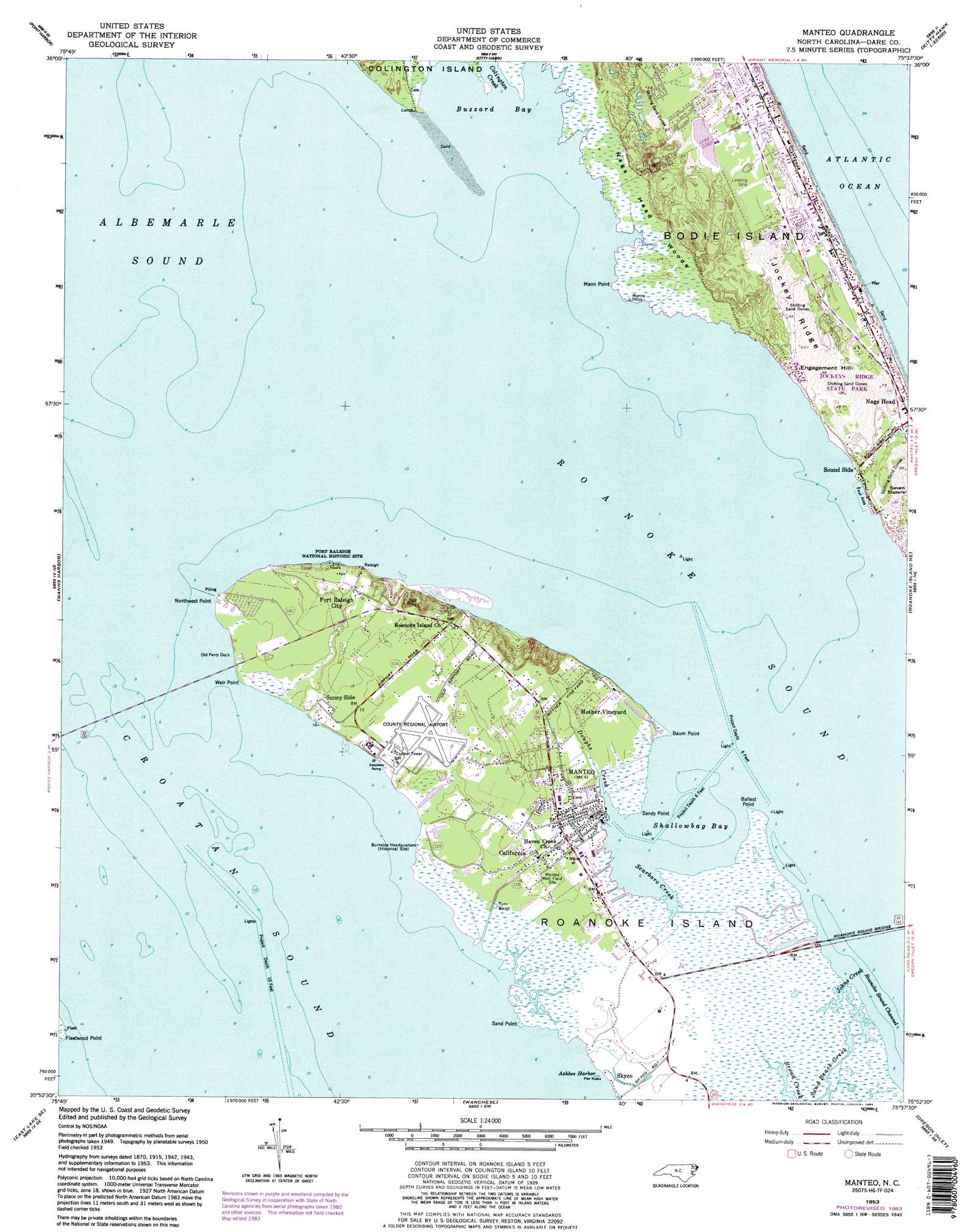
Manteo Topo Map North Carolina
To zoom in, hover over the map of Manteo
USGS Topo Quad 35075h6 - 1:24,000 scale
| Topo Map Name: | Manteo |
| USGS Topo Quad ID: | 35075h6 |
| Print Size: | ca. 21 1/4" wide x 27" high |
| Southeast Coordinates: | 35.875° N latitude / 75.625° W longitude |
| Map Center Coordinates: | 35.9375° N latitude / 75.6875° W longitude |
| U.S. State: | NC |
| Filename: | o35075h6.jpg |
| Download Map JPG Image: | Manteo topo map 1:24,000 scale |
| Map Type: | Topographic |
| Topo Series: | 7.5´ |
| Map Scale: | 1:24,000 |
| Source of Map Images: | United States Geological Survey (USGS) |
| Alternate Map Versions: |
Manteo NC 1953, updated 1956 Download PDF Buy paper map Manteo NC 1953, updated 1968 Download PDF Buy paper map Manteo NC 1953, updated 1977 Download PDF Buy paper map Manteo NC 1953, updated 1984 Download PDF Buy paper map Manteo NC 1953, updated 1984 Download PDF Buy paper map Manteo NC 2011 Download PDF Buy paper map Manteo NC 2013 Download PDF Buy paper map Manteo NC 2016 Download PDF Buy paper map |
1:24,000 Topo Quads surrounding Manteo
Camden Point |
Jarvisburg |
Martin Point |
||
Point Harbor |
Kitty Hawk |
|||
East Lake |
Manns Harbor |
Manteo |
Roanoke Island Ne |
|
Buffalo City |
East Lake Se |
Wanchese |
Oregon Inlet |
|
Engelhard Nw |
Engelhard Ne |
Stumpy Point |
> Back to 35075e1 at 1:100,000 scale
> Back to 35074a1 at 1:250,000 scale
> Back to U.S. Topo Maps home
Manteo topo map: Gazetteer
Manteo: Airports
Dare County Airport elevation 3m 9′Manteo Airport elevation 3m 9′
Outer Banks Airport elevation 11m 36′
Manteo: Areas
Elizabethan Gardens elevation 4m 13′First Creeks elevation 1m 3′
Manteo: Bars
Blockade Shoal elevation 0m 0′Colington Island Shoal elevation 0m 0′
Fulker Shoal (historical) elevation 0m 0′
Manteo: Basins
Turn Basin elevation 1m 3′Manteo: Bays
Ashbee Harbor elevation 0m 0′Black Hall Bay elevation 0m 0′
Buzzard Bay elevation 0m 0′
Otis Cove elevation 0m 0′
Scarboro Creek elevation 0m 0′
Shallowbag Bay elevation 0m 0′
Manteo: Bridges
Ananias Dare Street Bridge elevation 0m 0′Roanoke Sound Bridge elevation 0m 0′
William B Umstead Memorial Bridge elevation 0m 0′
Manteo: Canals
Hammock Ditch elevation 0m 0′McKnights Ditch elevation 0m 0′
Manteo: Capes
Ballast Point elevation 0m 0′Baum Point elevation 0m 0′
Bens Point elevation 0m 0′
Buzzard Point elevation 0m 0′
Crab Claw Spit elevation 0m 0′
Deep Ditch Point elevation 0m 0′
Deep Wear Point elevation 0m 0′
Fleetwood Point elevation -5m -17′
Mann Point elevation 1m 3′
Northwest Point elevation 0m 0′
Pork Point elevation 0m 0′
Sand Point elevation 0m 0′
Sandy Point elevation 0m 0′
Scarboro Point elevation 1m 3′
Weir Point elevation 0m 0′
Manteo: Guts
Colington Cut elevation 1m 3′Manteo: Islands
Fulker Island (historical) elevation 0m 0′Ice Plant Island elevation 0m 0′
Roanoke Island elevation 0m 0′
Manteo: Parks
Cape Hatteras Group Headquarters elevation 5m 16′Fort Raleigh National Historic Site elevation 3m 9′
Jockey's Ridge State Park elevation 6m 19′
Lindsay Warren Visitor Center elevation 5m 16′
Roanoke Island Festival Park elevation 0m 0′
Manteo: Populated Places
California elevation 2m 6′Fort Raleigh City elevation 4m 13′
Manteo elevation 2m 6′
Mother Vineyard elevation 1m 3′
Roanoac (historical) elevation 0m 0′
Sound Side elevation 1m 3′
Sunny Side elevation 2m 6′
Manteo: Ridges
Jockeys Ridge elevation 12m 39′Manteo: Streams
Doughs Creek elevation 0m 0′Johns Creek elevation 0m 0′
Sand Beach Creek elevation 0m 0′
Manteo: Summits
Engagement Hill elevation 6m 19′Manteo: Trails
Thomas Hariot Nature Trail elevation 4m 13′Manteo: Woods
Nags Head Woods elevation 0m 0′Manteo digital topo map on disk
Buy this Manteo topo map showing relief, roads, GPS coordinates and other geographical features, as a high-resolution digital map file on DVD:
Atlantic Coast (NY, NJ, PA, DE, MD, VA, NC)
Buy digital topo maps: Atlantic Coast (NY, NJ, PA, DE, MD, VA, NC)
 map DVD")