Bearskin Topo Map North Carolina
To zoom in, hover over the map of Bearskin
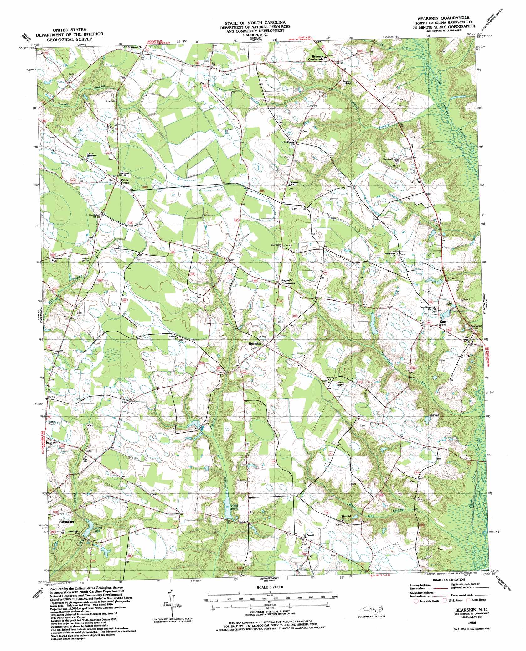
USGS Topo Quad 35078a4 - 1:24,000 scale
| Topo Map Name: | Bearskin |
| USGS Topo Quad ID: | 35078a4 |
| Print Size: | ca. 21 1/4" wide x 27" high |
| Southeast Coordinates: | 35° N latitude / 78.375° W longitude |
| Map Center Coordinates: | 35.0625° N latitude / 78.4375° W longitude |
| U.S. State: | NC |
| Filename: | o35078a4.jpg |
| Download Map JPG Image: | Bearskin topo map 1:24,000 scale |
| Map Type: | Topographic |
| Topo Series: | 7.5´ |
| Map Scale: | 1:24,000 |
| Source of Map Images: | United States Geological Survey (USGS) |
| Alternate Map Versions: |
Bearskin NC 1986, updated 1986 Download PDF Buy paper map Bearskin NC 2010 Download PDF Buy paper map Bearskin NC 2013 Download PDF Buy paper map Bearskin NC 2016 Download PDF Buy paper map |
1:24,000 Topo Quads surrounding Bearskin
Erwin |
Dunn |
Peacocks Crossroads |
Newton Grove North |
Grantham |
Wade |
Mingo |
Timothy |
Newton Grove South |
Dobbersville |
Stedman |
Salemburg |
Bearskin |
Clinton North |
Faison |
Autryville |
Roseboro |
Bonnetsville |
Clinton South |
Turkey |
Jerome |
Ammon |
Garland |
Ingold |
Delway |
> Back to 35078a1 at 1:100,000 scale
> Back to 35078a1 at 1:250,000 scale
> Back to U.S. Topo Maps home
Bearskin topo map: Gazetteer
Bearskin: Dams
Laurel Lake Dam elevation 40m 131′Bearskin: Populated Places
Beaman Crossroads elevation 53m 173′Bearskin elevation 53m 173′
Kitty Fork elevation 51m 167′
Piney Green elevation 56m 183′
Reynolds Crossroads elevation 54m 177′
Bearskin: Reservoirs
Halls Pond elevation 38m 124′Laurel Lake elevation 38m 124′
Bearskin: Streams
Beaverdam Run elevation 29m 95′Marsh Swamp elevation 33m 108′
Old Mill Swamp elevation 34m 111′
White Oak Swamp elevation 27m 88′
Bearskin digital topo map on disk
Buy this Bearskin topo map showing relief, roads, GPS coordinates and other geographical features, as a high-resolution digital map file on DVD:
South Carolina, Western North Carolina & Northeastern Georgia
Buy digital topo maps: South Carolina, Western North Carolina & Northeastern Georgia