Jerome Topo Map North Carolina
To zoom in, hover over the map of Jerome
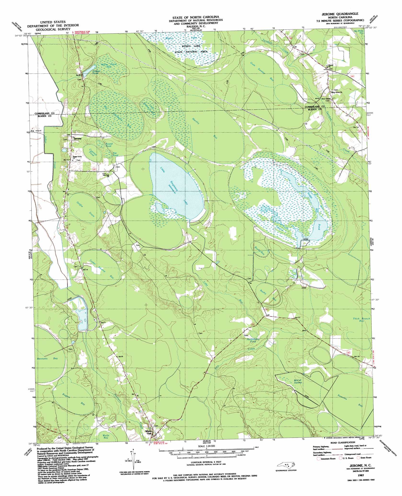
USGS Topo Quad 34078g6 - 1:24,000 scale
| Topo Map Name: | Jerome |
| USGS Topo Quad ID: | 34078g6 |
| Print Size: | ca. 21 1/4" wide x 27" high |
| Southeast Coordinates: | 34.75° N latitude / 78.625° W longitude |
| Map Center Coordinates: | 34.8125° N latitude / 78.6875° W longitude |
| U.S. State: | NC |
| Filename: | o34078g6.jpg |
| Download Map JPG Image: | Jerome topo map 1:24,000 scale |
| Map Type: | Topographic |
| Topo Series: | 7.5´ |
| Map Scale: | 1:24,000 |
| Source of Map Images: | United States Geological Survey (USGS) |
| Alternate Map Versions: |
Jerome NC 1987, updated 1987 Download PDF Buy paper map Jerome NC 2002, updated 2002 Download PDF Buy paper map Jerome NC 2010 Download PDF Buy paper map Jerome NC 2013 Download PDF Buy paper map Jerome NC 2016 Download PDF Buy paper map |
1:24,000 Topo Quads surrounding Jerome
Fayetteville |
Vander |
Stedman |
Salemburg |
Bearskin |
Hope Mills |
Cedar Creek |
Autryville |
Roseboro |
Bonnetsville |
Saint Pauls |
Duart |
Jerome |
Ammon |
Garland |
Northeast Lumberton |
Tar Heel |
Dublin |
Elizabethtown North |
White Lake |
Southeast Lumberton |
Bladenboro |
Abbottsburg |
Elizabethtown South |
Singletary Lake |
> Back to 34078e1 at 1:100,000 scale
> Back to 34078a1 at 1:250,000 scale
> Back to U.S. Topo Maps home
Jerome topo map: Gazetteer
Jerome: Basins
Bucks Bay elevation 34m 111′Marshy Bay elevation 34m 111′
Sessoms Bay elevation 28m 91′
Thick Branch Bay elevation 30m 98′
Jerome: Dams
Broadwell Lake Dam elevation 27m 88′C R Smith Dam elevation 30m 98′
Horseshoe Lake Dam elevation 32m 104′
Jerome: Islands
Big Island elevation 24m 78′Jerome: Lakes
Horseshoe Lake elevation 32m 104′Little Singletary Lake elevation 30m 98′
Jerome: Parks
Bushy Lake State Natural Area elevation 34m 111′Jerome: Populated Places
Jerome elevation 33m 108′Jerome: Reservoirs
Broadwell Lake elevation 27m 88′Jessups Pond elevation 30m 98′
Jerome: Streams
Indian Creek elevation 21m 68′Lake Run elevation 24m 78′
Jerome: Swamps
Bennetts Bay elevation 25m 82′Big Gallberry Bay elevation 33m 108′
Bushy Bay elevation 31m 101′
Cedar Swamp Bay elevation 23m 75′
Cypress Pond elevation 32m 104′
Flat Pond elevation 32m 104′
Griffie Drain elevation 25m 82′
Gum Swamp Bay elevation 32m 104′
Huckleberry Pond elevation 25m 82′
Little Gallberry Bay elevation 35m 114′
McCall Swamp elevation 26m 85′
Rogers Bay elevation 23m 75′
Round Pond elevation 33m 108′
White Pond Bay elevation 30m 98′
Wolfs Bay elevation 23m 75′
Jerome digital topo map on disk
Buy this Jerome topo map showing relief, roads, GPS coordinates and other geographical features, as a high-resolution digital map file on DVD:
South Carolina, Western North Carolina & Northeastern Georgia
Buy digital topo maps: South Carolina, Western North Carolina & Northeastern Georgia