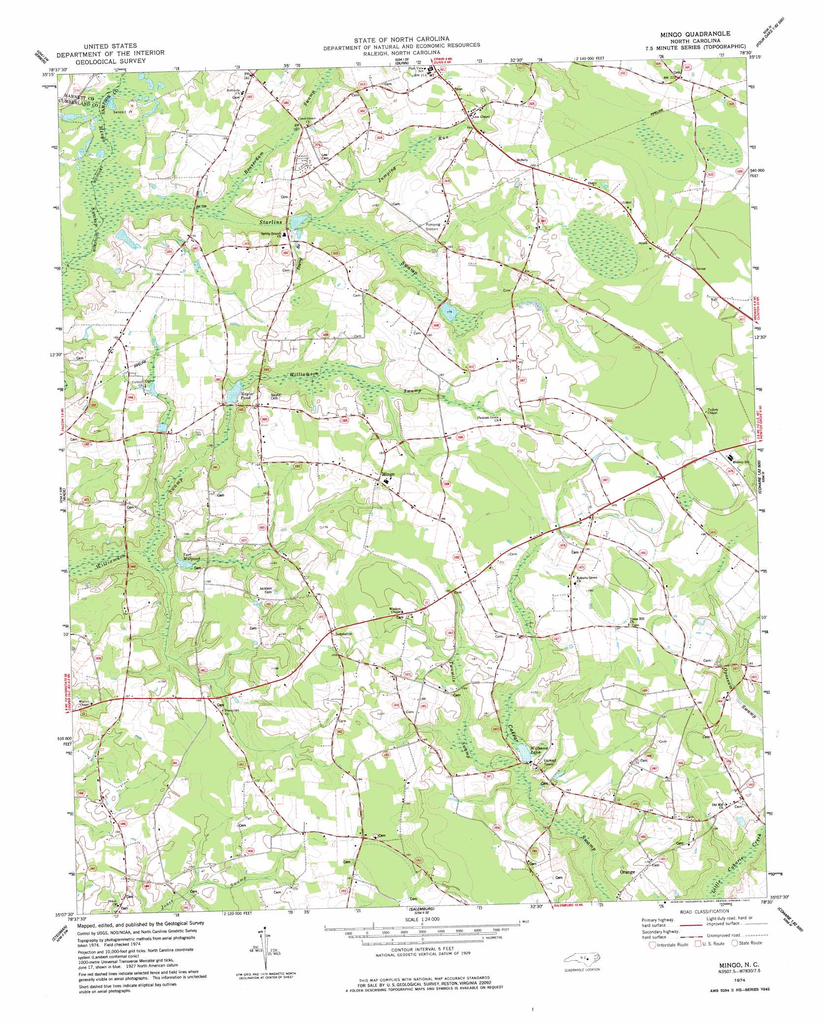
Mingo Topo Map North Carolina
To zoom in, hover over the map of Mingo
USGS Topo Quad 35078b5 - 1:24,000 scale
| Topo Map Name: | Mingo |
| USGS Topo Quad ID: | 35078b5 |
| Print Size: | ca. 21 1/4" wide x 27" high |
| Southeast Coordinates: | 35.125° N latitude / 78.5° W longitude |
| Map Center Coordinates: | 35.1875° N latitude / 78.5625° W longitude |
| U.S. State: | NC |
| Filename: | o35078b5.jpg |
| Download Map JPG Image: | Mingo topo map 1:24,000 scale |
| Map Type: | Topographic |
| Topo Series: | 7.5´ |
| Map Scale: | 1:24,000 |
| Source of Map Images: | United States Geological Survey (USGS) |
| Alternate Map Versions: |
Mingo NC 1974, updated 1977 Download PDF Buy paper map Mingo NC 2010 Download PDF Buy paper map Mingo NC 2013 Download PDF Buy paper map Mingo NC 2016 Download PDF Buy paper map |
1:24,000 Topo Quads surrounding Mingo
Lillington |
Coats |
Benson |
Four Oaks |
Four Oaks Ne |
Bunnlevel |
Erwin |
Dunn |
Peacocks Crossroads |
Newton Grove North |
Slocomb |
Wade |
Mingo |
Timothy |
Newton Grove South |
Vander |
Stedman |
Salemburg |
Bearskin |
Clinton North |
Cedar Creek |
Autryville |
Roseboro |
Bonnetsville |
Clinton South |
> Back to 35078a1 at 1:100,000 scale
> Back to 35078a1 at 1:250,000 scale
> Back to U.S. Topo Maps home
Mingo topo map: Gazetteer
Mingo: Populated Places
Mingo elevation 58m 190′Orange elevation 51m 167′
Plain View elevation 62m 203′
Mingo: Reservoirs
Naylor Pond elevation 45m 147′Tart Millpond elevation 40m 131′
Williams Lake elevation 44m 144′
Mingo: Streams
Beaverdam Swamp elevation 42m 137′Jumping Run elevation 46m 150′
Spring Branch elevation 46m 150′
Starlins Swamp elevation 38m 124′
Twomile Swamp elevation 43m 141′
Mingo: Swamps
Beaverdam Dismal elevation 63m 206′Mingo digital topo map on disk
Buy this Mingo topo map showing relief, roads, GPS coordinates and other geographical features, as a high-resolution digital map file on DVD:
South Carolina, Western North Carolina & Northeastern Georgia
Buy digital topo maps: South Carolina, Western North Carolina & Northeastern Georgia