Cleveland Topo Map North Carolina
To zoom in, hover over the map of Cleveland
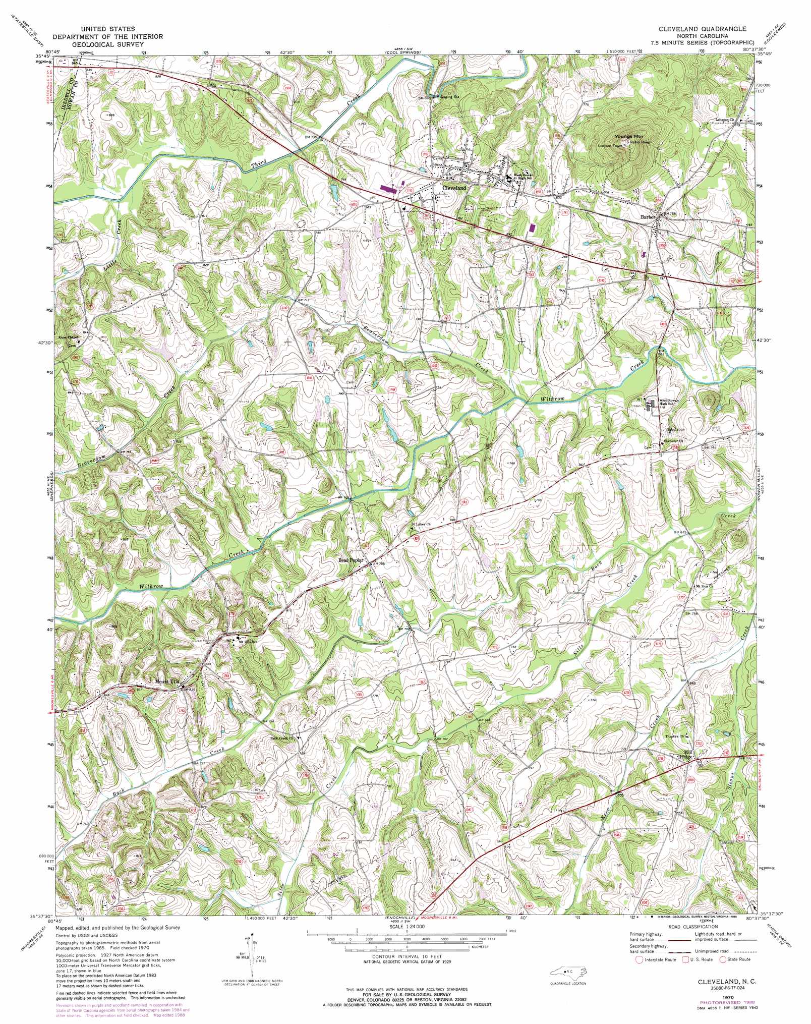
USGS Topo Quad 35080f6 - 1:24,000 scale
| Topo Map Name: | Cleveland |
| USGS Topo Quad ID: | 35080f6 |
| Print Size: | ca. 21 1/4" wide x 27" high |
| Southeast Coordinates: | 35.625° N latitude / 80.625° W longitude |
| Map Center Coordinates: | 35.6875° N latitude / 80.6875° W longitude |
| U.S. State: | NC |
| Filename: | o35080f6.jpg |
| Download Map JPG Image: | Cleveland topo map 1:24,000 scale |
| Map Type: | Topographic |
| Topo Series: | 7.5´ |
| Map Scale: | 1:24,000 |
| Source of Map Images: | United States Geological Survey (USGS) |
| Alternate Map Versions: |
Cleveland NC 1970, updated 1972 Download PDF Buy paper map Cleveland NC 1970, updated 1989 Download PDF Buy paper map Cleveland NC 2010 Download PDF Buy paper map Cleveland NC 2013 Download PDF Buy paper map Cleveland NC 2016 Download PDF Buy paper map |
1:24,000 Topo Quads surrounding Cleveland
Central |
Harmony |
Calahaln |
Mocksville |
Advance |
Statesville West |
Statesville East |
Cool Springs |
Cooleemee |
Churchland |
Troutman |
Shepherds |
Cleveland |
Rowan Mills |
Salisbury |
Lake Norman North |
Mooresville |
Enochville |
China Grove |
Rockwell |
Lake Norman South |
Cornelius |
Kannapolis |
Concord |
Mount Pleasant |
> Back to 35080e1 at 1:100,000 scale
> Back to 35080a1 at 1:250,000 scale
> Back to U.S. Topo Maps home
Cleveland topo map: Gazetteer
Cleveland: Dams
Hall Lake Dam elevation 217m 711′Cleveland: Parks
Kerr Mill Park elevation 246m 807′Cleveland: Populated Places
Barber elevation 224m 734′Bear Poplar elevation 237m 777′
Blackmer (historical) elevation 220m 721′
Chowansville (historical) elevation 215m 705′
Cleveland elevation 247m 810′
Houston (historical) elevation 216m 708′
Mill Bridge elevation 240m 787′
Mount Ulla elevation 251m 823′
Rowan Mills (historical) elevation 216m 708′
Cleveland: Reservoirs
Hall Lake elevation 217m 711′Cleveland: Streams
Back Creek elevation 203m 666′Beaverdam Creek elevation 207m 679′
Kerr Creek elevation 207m 679′
Little Creek elevation 218m 715′
Sills Creek elevation 205m 672′
Sloans Creek elevation 202m 662′
Cleveland: Summits
Youngs Mountain elevation 332m 1089′Cleveland digital topo map on disk
Buy this Cleveland topo map showing relief, roads, GPS coordinates and other geographical features, as a high-resolution digital map file on DVD:
South Carolina, Western North Carolina & Northeastern Georgia
Buy digital topo maps: South Carolina, Western North Carolina & Northeastern Georgia