Springvale Topo Map Tennessee
To zoom in, hover over the map of Springvale
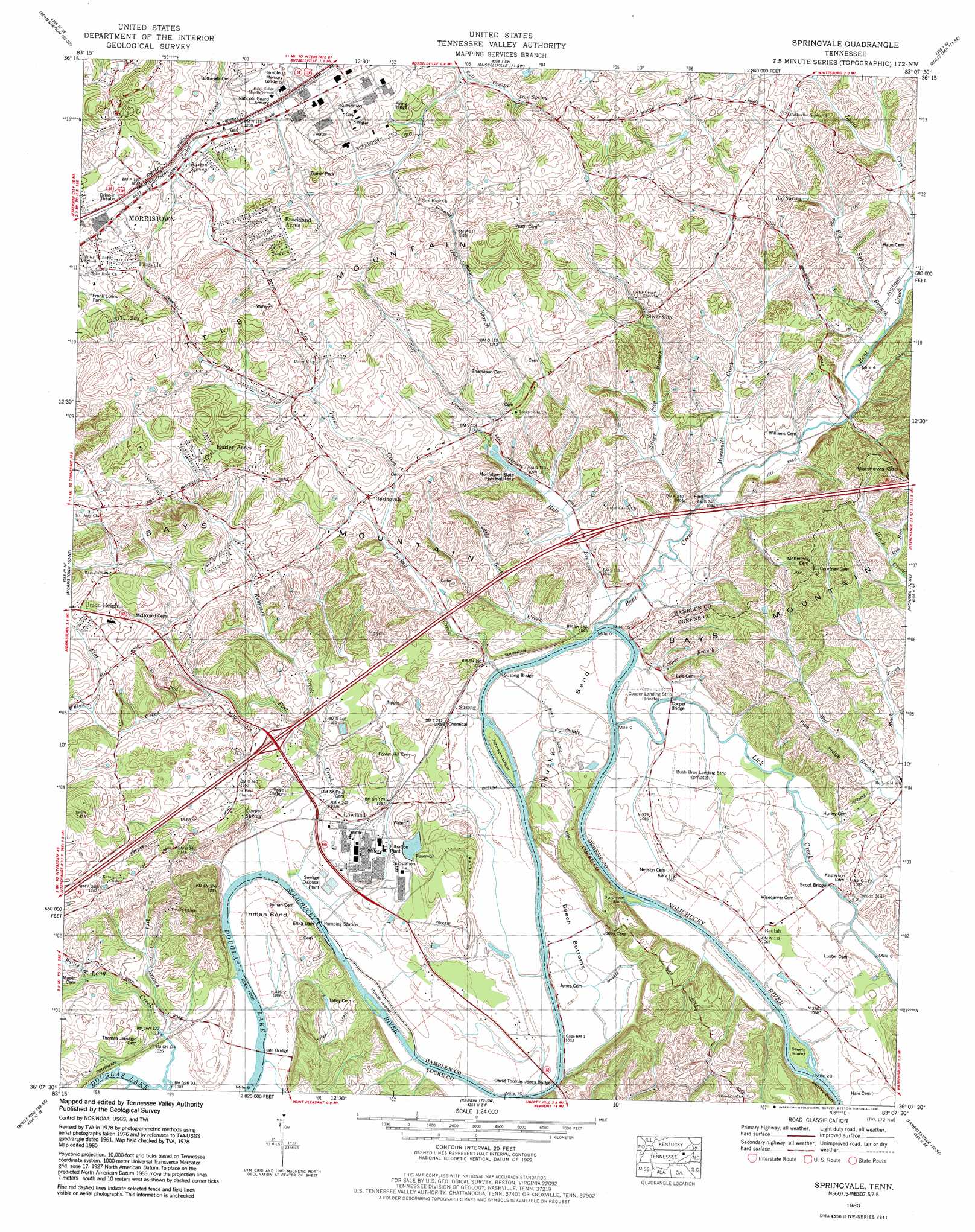
USGS Topo Quad 36083b2 - 1:24,000 scale
| Topo Map Name: | Springvale |
| USGS Topo Quad ID: | 36083b2 |
| Print Size: | ca. 21 1/4" wide x 27" high |
| Southeast Coordinates: | 36.125° N latitude / 83.125° W longitude |
| Map Center Coordinates: | 36.1875° N latitude / 83.1875° W longitude |
| U.S. State: | TN |
| Filename: | o36083b2.jpg |
| Download Map JPG Image: | Springvale topo map 1:24,000 scale |
| Map Type: | Topographic |
| Topo Series: | 7.5´ |
| Map Scale: | 1:24,000 |
| Source of Map Images: | United States Geological Survey (USGS) |
| Alternate Map Versions: |
Springvale TN 1935 Download PDF Buy paper map Springvale TN 1939 Download PDF Buy paper map Springvale TN 1939, updated 1954 Download PDF Buy paper map Springvale TN 1961, updated 1963 Download PDF Buy paper map Springvale TN 1961, updated 1977 Download PDF Buy paper map Springvale TN 1980, updated 1981 Download PDF Buy paper map Springvale TN 2011 Download PDF Buy paper map Springvale TN 2013 Download PDF Buy paper map Springvale TN 2016 Download PDF Buy paper map |
1:24,000 Topo Quads surrounding Springvale
Howard Quarter |
Swan Island |
Lee Valley |
Camelot |
Burem |
Avondale |
Bean Station |
Russellville |
Bulls Gap |
Mccloud |
Talbott |
Morristown |
Springvale |
Mohawk |
Mosheim |
Jefferson City |
White Pine |
Rankin |
Parrotsville |
Cedar Creek |
Shady Grove |
Chestnut Hill |
Newport |
Neddy Mountain |
Paint Rock |
> Back to 36083a1 at 1:100,000 scale
> Back to 36082a1 at 1:250,000 scale
> Back to U.S. Topo Maps home
Springvale topo map: Gazetteer
Springvale: Airports
Bush Brothers Strip Airport elevation 315m 1033′Cooper Landing Strip elevation 314m 1030′
Springvale: Bars
Andersons Shoals elevation 310m 1017′Hills Shoals elevation 312m 1023′
Smith Shoals elevation 315m 1033′
Springvale: Bends
Beech Bottoms elevation 312m 1023′Chucky Bend elevation 326m 1069′
Inman Bend elevation 311m 1020′
Springvale: Bridges
Cooper Bridge elevation 314m 1030′David Thomas Jones Bridge elevation 308m 1010′
Hale Bridge elevation 305m 1000′
Scoot Bridge elevation 317m 1040′
Susong Bridge elevation 311m 1020′
Springvale: Cliffs
Skulley Bluff elevation 325m 1066′Springvale: Crossings
Cane Ford elevation 315m 1033′Inman Ford elevation 308m 1010′
Interchange 12 elevation 347m 1138′
Interchange 15 elevation 325m 1066′
Springvale: Dams
Enka Dam elevation 307m 1007′Springvale: Gaps
Matthews Gap elevation 371m 1217′Springvale: Islands
Hurley Island elevation 308m 1010′Johnson Island elevation 314m 1030′
Solomon Island elevation 317m 1040′
Steele Island elevation 320m 1049′
Springvale: Parks
Frank Lorino Park elevation 406m 1332′Springvale: Populated Places
Barton Springs elevation 383m 1256′Belair elevation 408m 1338′
Beulah elevation 323m 1059′
Brockland Acres elevation 444m 1456′
Chuckey Bend (historical) elevation 319m 1046′
Creek Store elevation 321m 1053′
Dover elevation 411m 1348′
East Village elevation 433m 1420′
Fuller Estates elevation 404m 1325′
Glendale elevation 368m 1207′
Hurley Acres elevation 408m 1338′
Inman (historical) elevation 314m 1030′
Kingswood elevation 409m 1341′
Lampkin Acres elevation 427m 1400′
Mount Airy Springs elevation 436m 1430′
Nenny elevation 383m 1256′
Pineville elevation 421m 1381′
Rocky Point elevation 365m 1197′
Scoot Mill elevation 327m 1072′
Sherwood Estates elevation 409m 1341′
Silver City elevation 346m 1135′
Springvale elevation 367m 1204′
Susong elevation 321m 1053′
Union Heights elevation 403m 1322′
Windvue Estates elevation 418m 1371′
Wolf Acres elevation 416m 1364′
Springvale: Post Offices
Lowland Post Office elevation 318m 1043′Springvale: Ridges
Flea Ridge elevation 343m 1125′Little Mountain elevation 467m 1532′
Springvale: Springs
Barton Spring elevation 384m 1259′Big Spring elevation 343m 1125′
Cooper Spring elevation 316m 1036′
Iron Spring elevation 389m 1276′
Springvale: Streams
Bailey Branch elevation 315m 1033′Bent Creek elevation 313m 1026′
Big Spring Branch elevation 328m 1076′
Cooper Branch elevation 313m 1026′
Dry Branch elevation 307m 1007′
Flat Creek elevation 306m 1003′
Hale Branch elevation 314m 1030′
Kneelas Creek elevation 306m 1003′
Lick Creek elevation 313m 1026′
Little Bent Creek elevation 313m 1026′
Long Creek elevation 305m 1000′
Marshall Creek elevation 316m 1036′
Red Run elevation 339m 1112′
Robinson Creek elevation 322m 1056′
Silver City Branch elevation 315m 1033′
Slate Creek elevation 310m 1017′
Slop Branch elevation 344m 1128′
Turkey Creek elevation 312m 1023′
Willow Creek elevation 364m 1194′
Springvale digital topo map on disk
Buy this Springvale topo map showing relief, roads, GPS coordinates and other geographical features, as a high-resolution digital map file on DVD:
Western Virginia & Southern West Virginia
Buy digital topo maps: Western Virginia & Southern West Virginia