Samson Lake Topo Map New Mexico
To zoom in, hover over the map of Samson Lake
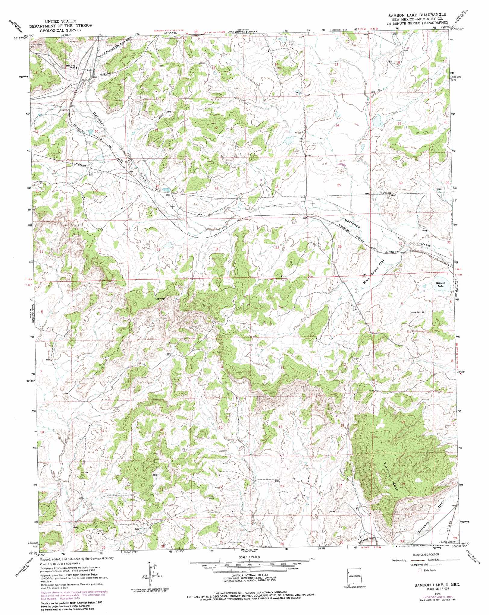
USGS Topo Quad 35108e8 - 1:24,000 scale
| Topo Map Name: | Samson Lake |
| USGS Topo Quad ID: | 35108e8 |
| Print Size: | ca. 21 1/4" wide x 27" high |
| Southeast Coordinates: | 35.5° N latitude / 108.875° W longitude |
| Map Center Coordinates: | 35.5625° N latitude / 108.9375° W longitude |
| U.S. State: | NM |
| Filename: | o35108e8.jpg |
| Download Map JPG Image: | Samson Lake topo map 1:24,000 scale |
| Map Type: | Topographic |
| Topo Series: | 7.5´ |
| Map Scale: | 1:24,000 |
| Source of Map Images: | United States Geological Survey (USGS) |
| Alternate Map Versions: |
Samson Lake NM 1963, updated 1967 Download PDF Buy paper map Samson Lake NM 2010 Download PDF Buy paper map Samson Lake NM 2013 Download PDF Buy paper map Samson Lake NM 2017 Download PDF Buy paper map |
1:24,000 Topo Quads surrounding Samson Lake
Piney Hill |
Fort Defiance |
Crevasse Canyon |
Tohatchi |
Chuska Lake |
West Of Window Rock |
Window Rock |
Tse Bonita School |
Twin Lakes |
Big Rock Hill |
Joe Woody Well |
Hunters Point |
Samson Lake |
Gallup West |
Gallup East |
Uranium Spring |
Surrender Canyon |
Manuelito |
Twin Buttes |
Bread Springs |
Houck |
Lupton |
Jones Ranch School |
Vander Wagen |
Pinehaven |
> Back to 35108e1 at 1:100,000 scale
> Back to 35108a1 at 1:250,000 scale
> Back to U.S. Topo Maps home
Samson Lake topo map: Gazetteer
Samson Lake: Flats
Blue Grass Flat elevation 1987m 6519′Samson Lake: Lakes
Samson Lake elevation 1978m 6489′Samson Lake: Mines
McKinley Mine elevation 2090m 6856′US Minning Section Six elevation 1991m 6532′
Samson Lake: Ridges
Torrivio Ridge elevation 2043m 6702′Samson Lake: Springs
Manuelito Spring elevation 1954m 6410′Parker Spring elevation 1978m 6489′
Samson Lake: Streams
Burned Through the Rock Wash elevation 2082m 6830′Samson Lake: Summits
Torrivio Mesa elevation 2141m 7024′Samson Lake: Wells
16T-339 Water Well elevation 1952m 6404′Samson Lake digital topo map on disk
Buy this Samson Lake topo map showing relief, roads, GPS coordinates and other geographical features, as a high-resolution digital map file on DVD: