Essex Topo Map North Carolina
To zoom in, hover over the map of Essex
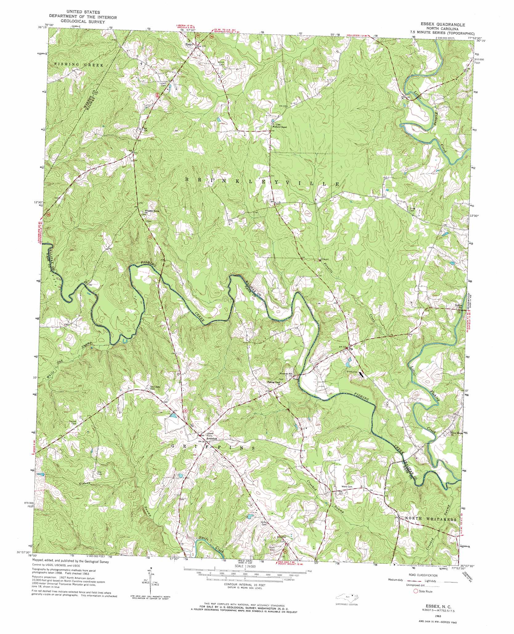
USGS Topo Quad 36077b8 - 1:24,000 scale
| Topo Map Name: | Essex |
| USGS Topo Quad ID: | 36077b8 |
| Print Size: | ca. 21 1/4" wide x 27" high |
| Southeast Coordinates: | 36.125° N latitude / 77.875° W longitude |
| Map Center Coordinates: | 36.1875° N latitude / 77.9375° W longitude |
| U.S. State: | NC |
| Filename: | o36077b8.jpg |
| Download Map JPG Image: | Essex topo map 1:24,000 scale |
| Map Type: | Topographic |
| Topo Series: | 7.5´ |
| Map Scale: | 1:24,000 |
| Source of Map Images: | United States Geological Survey (USGS) |
| Alternate Map Versions: |
Essex NC 1963, updated 1964 Download PDF Buy paper map Essex NC 1963, updated 1964 Download PDF Buy paper map Essex NC 1998, updated 2000 Download PDF Buy paper map Essex NC 2010 Download PDF Buy paper map Essex NC 2013 Download PDF Buy paper map Essex NC 2016 Download PDF Buy paper map |
1:24,000 Topo Quads surrounding Essex
Warrenton |
Macon |
Littleton |
Thelma |
Roanoke Rapids |
Afton |
Inez |
Hollister |
Aurelian Springs |
Darlington |
Gold Sand |
Centerville |
Essex |
Ringwood |
Enfield |
Justice |
Castalia |
Red Oak |
Drake |
Whitakers |
Bunn East |
Spring Hope |
Nashville |
Rocky Mount |
Hartsease |
> Back to 36077a1 at 1:100,000 scale
> Back to 36076a1 at 1:250,000 scale
> Back to U.S. Topo Maps home
Essex topo map: Gazetteer
Essex: Bridges
Battles Bridge elevation 40m 131′Davis Bridge elevation 39m 127′
Rossers Bridge elevation 41m 134′
Essex: Dams
Doziers Lake Dam elevation 70m 229′Fraziers Pond Dam elevation 83m 272′
Ricks Pond Dam elevation 64m 209′
Essex: Populated Places
Aventon elevation 85m 278′Essex elevation 83m 272′
Ita elevation 61m 200′
Essex: Post Offices
Aventon Post Office elevation 85m 278′Essex: Reservoirs
Doziers Lake elevation 70m 229′Fraziers Pond elevation 83m 272′
Ricks Pond elevation 64m 209′
Essex: Streams
Crooked Swamp elevation 34m 111′Little Fishing Creek elevation 35m 114′
Powells Creek elevation 39m 127′
White Oak Swamp elevation 42m 137′
Essex: Trails
Bluff Loop Trail elevation 52m 170′Stream Loop Trail elevation 51m 167′
Essex digital topo map on disk
Buy this Essex topo map showing relief, roads, GPS coordinates and other geographical features, as a high-resolution digital map file on DVD:
Atlantic Coast (NY, NJ, PA, DE, MD, VA, NC)
Buy digital topo maps: Atlantic Coast (NY, NJ, PA, DE, MD, VA, NC)
 map DVD")