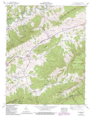
Elk Garden Topo Map Virginia
To zoom in, hover over the map of Elk Garden
USGS Topo Quad 36081h8 - 1:24,000 scale
| Topo Map Name: | Elk Garden |
| USGS Topo Quad ID: | 36081h8 |
| Print Size: | ca. 21 1/4" wide x 27" high |
| Southeast Coordinates: | 36.875° N latitude / 81.875° W longitude |
| Map Center Coordinates: | 36.9375° N latitude / 81.9375° W longitude |
| U.S. State: | VA |
| Filename: | o36081h8.jpg |
| Download Map JPG Image: | Elk Garden topo map 1:24,000 scale |
| Map Type: | Topographic |
| Topo Series: | 7.5´ |
| Map Scale: | 1:24,000 |
| Source of Map Images: | United States Geological Survey (USGS) |
| Alternate Map Versions: |
Elk Garden VA 1935 Download PDF Buy paper map Elk Garden VA 1958, updated 1960 Download PDF Buy paper map Elk Garden VA 1958, updated 1960 Download PDF Buy paper map Elk Garden VA 1958, updated 1972 Download PDF Buy paper map Elk Garden VA 1958, updated 1978 Download PDF Buy paper map Elk Garden VA 1958, updated 1991 Download PDF Buy paper map Elk Garden VA 1958, updated 1993 Download PDF Buy paper map Elk Garden VA 2011 Download PDF Buy paper map Elk Garden VA 2013 Download PDF Buy paper map Elk Garden VA 2016 Download PDF Buy paper map |
| FStopo: | US Forest Service topo Elk Garden is available: Download FStopo PDF Download FStopo TIF |
1:24,000 Topo Quads surrounding Elk Garden
> Back to 36081e1 at 1:100,000 scale
> Back to 36080a1 at 1:250,000 scale
> Back to U.S. Topo Maps home
Elk Garden topo map: Gazetteer
Elk Garden: Bends
Hubbard Hole elevation 538m 1765′Elk Garden: Dams
Gent Brothers Dam elevation 708m 2322′Elk Garden: Gaps
Rich Mountain Gap elevation 949m 3113′White Rock Gap elevation 1135m 3723′
Elk Garden: Lakes
Lake Mountain Top elevation 707m 2319′Elk Garden: Populated Places
Blackford elevation 550m 1804′Corn Valley elevation 710m 2329′
Elk Garden elevation 650m 2132′
Hubbard Junction elevation 543m 1781′
Jacksons Store elevation 793m 2601′
Rockdell elevation 669m 2194′
Rosedale elevation 691m 2267′
Smithfield elevation 673m 2208′
Elk Garden: Reservoirs
Gent Lake elevation 708m 2322′Elk Garden: Ridges
Buckhorn Ridge elevation 977m 3205′Elk Garden: Streams
Broadwine Branch elevation 753m 2470′Dry Branch elevation 645m 2116′
Fogleman Branch elevation 709m 2326′
Hubbard Branch elevation 538m 1765′
Lewis Creek elevation 536m 1758′
Mill Branch elevation 551m 1807′
Nicey Branch elevation 718m 2355′
Oliver Branch elevation 661m 2168′
Ramp Cove Branch elevation 655m 2148′
Sturgeon Branch elevation 786m 2578′
The Doubles Branch elevation 558m 1830′
Thompson Branch elevation 528m 1732′
Elk Garden: Summits
Beartown Mountain elevation 1356m 4448′House and Barn Mountain elevation 1074m 3523′
Poor Mountain elevation 1032m 3385′
Potato Hill Knob elevation 1157m 3795′
Rich Mountain elevation 1059m 3474′
River Mountain elevation 959m 3146′
Smith Knob elevation 925m 3034′
The Doubles elevation 889m 2916′
The Loop elevation 851m 2791′
Webb Mountain elevation 918m 3011′
Elk Garden: Valleys
Hess Hollow elevation 573m 1879′Howard Hollow elevation 584m 1916′
John Hess Hollow elevation 565m 1853′
Johnson Hollow elevation 684m 2244′
Patrick Hollow elevation 537m 1761′
Elk Garden digital topo map on disk
Buy this Elk Garden topo map showing relief, roads, GPS coordinates and other geographical features, as a high-resolution digital map file on DVD:
Western Virginia & Southern West Virginia
Buy digital topo maps: Western Virginia & Southern West Virginia


