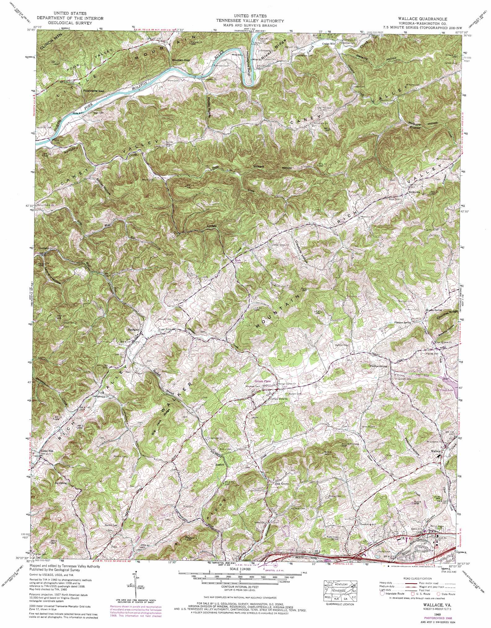
Wallace Topo Map Virginia
To zoom in, hover over the map of Wallace
USGS Topo Quad 36082f2 - 1:24,000 scale
| Topo Map Name: | Wallace |
| USGS Topo Quad ID: | 36082f2 |
| Print Size: | ca. 21 1/4" wide x 27" high |
| Southeast Coordinates: | 36.625° N latitude / 82.125° W longitude |
| Map Center Coordinates: | 36.6875° N latitude / 82.1875° W longitude |
| U.S. State: | VA |
| Filename: | o36082f2.jpg |
| Download Map JPG Image: | Wallace topo map 1:24,000 scale |
| Map Type: | Topographic |
| Topo Series: | 7.5´ |
| Map Scale: | 1:24,000 |
| Source of Map Images: | United States Geological Survey (USGS) |
| Alternate Map Versions: |
Wallace VA 1934 Download PDF Buy paper map Wallace VA 1938 Download PDF Buy paper map Wallace VA 1938, updated 1958 Download PDF Buy paper map Wallace VA 1960, updated 1962 Download PDF Buy paper map Wallace VA 1960, updated 1970 Download PDF Buy paper map Wallace VA 2010 Download PDF Buy paper map Wallace VA 2013 Download PDF Buy paper map Wallace VA 2016 Download PDF Buy paper map |
1:24,000 Topo Quads surrounding Wallace
Coeburn |
Saint Paul |
Carbo |
Lebanon |
Elk Garden |
Dungannon |
Moll Creek |
Hansonville |
Brumley |
Hayters Gap |
Hilton |
Mendota |
Wallace |
Wyndale |
Abingdon |
Indian Springs |
Blountville |
Bristol |
Holston Valley |
Shady Valley |
Boone Dam |
Bluff City |
Keenburg |
Carter |
Doe |
> Back to 36082e1 at 1:100,000 scale
> Back to 36082a1 at 1:250,000 scale
> Back to U.S. Topo Maps home
Wallace topo map: Gazetteer
Wallace: Basins
Caney Valley elevation 499m 1637′Wallace: Crossings
Buffalo Ford elevation 421m 1381′Interchange 3 elevation 562m 1843′
Interchange 5 elevation 547m 1794′
Wallace: Gaps
Robinette Gap elevation 421m 1381′Wooten Gap elevation 424m 1391′
Wallace: Populated Places
Benhams elevation 567m 1860′Burson Place elevation 615m 2017′
Craigs Mill elevation 430m 1410′
Fleenor Spring elevation 610m 2001′
Fleenors elevation 602m 1975′
Haskell elevation 623m 2043′
Leonard elevation 514m 1686′
Lime Hill elevation 567m 1860′
Lone Star elevation 557m 1827′
Oak Grove elevation 602m 1975′
Ravens Nest elevation 425m 1394′
Rocktown elevation 600m 1968′
Rush Corner elevation 578m 1896′
Wallace elevation 577m 1893′
Walnut Grove elevation 542m 1778′
Wolfrun (historical) elevation 509m 1669′
Woodsdale elevation 613m 2011′
Wallace: Reservoirs
Bristol Reservoir elevation 600m 1968′Crystal Pool elevation 562m 1843′
Wallace: Ridges
Big Jack Ridge elevation 746m 2447′Big Ridge elevation 719m 2358′
Wallace: Springs
Big Spring elevation 602m 1975′Harley Spring elevation 614m 2014′
Phillips Spring elevation 607m 1991′
Wallace: Streams
Gaspard Creek elevation 432m 1417′Goose Creek elevation 542m 1778′
Haskell Branch elevation 559m 1833′
Krimmel Creek elevation 484m 1587′
Nordyke Creek elevation 418m 1371′
Rattle Creek elevation 451m 1479′
Smith Creek elevation 425m 1394′
Wallace: Valleys
Bellamy Hollow elevation 436m 1430′Crawford Hollow elevation 604m 1981′
Leonard Hollow elevation 509m 1669′
McGuire Hollow elevation 487m 1597′
Muddy Hollow elevation 426m 1397′
Possum Hollow elevation 574m 1883′
Smiley Hollow elevation 435m 1427′
Sweetie Hollow elevation 601m 1971′
Vickers Hollow elevation 518m 1699′
Wallace digital topo map on disk
Buy this Wallace topo map showing relief, roads, GPS coordinates and other geographical features, as a high-resolution digital map file on DVD:
Western Virginia & Southern West Virginia
Buy digital topo maps: Western Virginia & Southern West Virginia