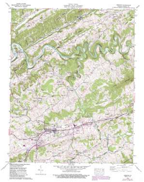
Lebanon Topo Map Virginia
To zoom in, hover over the map of Lebanon
USGS Topo Quad 36082h1 - 1:24,000 scale
| Topo Map Name: | Lebanon |
| USGS Topo Quad ID: | 36082h1 |
| Print Size: | ca. 21 1/4" wide x 27" high |
| Southeast Coordinates: | 36.875° N latitude / 82° W longitude |
| Map Center Coordinates: | 36.9375° N latitude / 82.0625° W longitude |
| U.S. State: | VA |
| Filename: | o36082h1.jpg |
| Download Map JPG Image: | Lebanon topo map 1:24,000 scale |
| Map Type: | Topographic |
| Topo Series: | 7.5´ |
| Map Scale: | 1:24,000 |
| Source of Map Images: | United States Geological Survey (USGS) |
| Alternate Map Versions: |
Lebanon VA 1934 Download PDF Buy paper map Lebanon VA 1958, updated 1960 Download PDF Buy paper map Lebanon VA 1958, updated 1960 Download PDF Buy paper map Lebanon VA 1958, updated 1971 Download PDF Buy paper map Lebanon VA 1958, updated 1978 Download PDF Buy paper map Lebanon VA 1958, updated 1992 Download PDF Buy paper map Lebanon VA 2010 Download PDF Buy paper map Lebanon VA 2013 Download PDF Buy paper map Lebanon VA 2016 Download PDF Buy paper map |
1:24,000 Topo Quads surrounding Lebanon
> Back to 36082e1 at 1:100,000 scale
> Back to 36082a1 at 1:250,000 scale
> Back to U.S. Topo Maps home
Lebanon topo map: Gazetteer
Lebanon: Airports
Clinchfield Heliport elevation 623m 2043′Lebanon: Basins
Combs Valley elevation 560m 1837′Lebanon: Bends
Bent Hole elevation 478m 1568′Pucketts Hole elevation 527m 1729′
Lebanon: Bridges
Charles Hayes Gilmer Bridge elevation 578m 1896′Lebanon: Cliffs
Pinnacle elevation 529m 1735′Lebanon: Falls
Big Falls elevation 506m 1660′Lebanon: Parks
Cedar Creek Park elevation 612m 2007′Lebanon: Populated Places
Artrip elevation 475m 1558′Barnett elevation 648m 2125′
Corner elevation 607m 1991′
Coulwood elevation 480m 1574′
Fullers elevation 498m 1633′
Head of Linefork elevation 567m 1860′
Lebanon elevation 628m 2060′
Nash Ford elevation 501m 1643′
Pondtown elevation 676m 2217′
Slabtown elevation 645m 2116′
Spring City elevation 648m 2125′
Stone Bruise elevation 674m 2211′
Lebanon: Post Offices
Bear Branch Post Office (historical) elevation 558m 1830′Gilley Post Office (historical) elevation 564m 1850′
Lebanon Post Office elevation 629m 2063′
Lebanon: Springs
Campbell Springs elevation 659m 2162′Roaring Spring elevation 648m 2125′
Lebanon: Streams
Alvy Creek elevation 491m 1610′Balltown Branch elevation 531m 1742′
Big Cedar Creek elevation 505m 1656′
Breezers Branch elevation 476m 1561′
Burgess Creek elevation 598m 1961′
Campbell Branch elevation 628m 2060′
Cowpen Branch elevation 481m 1578′
Dilly Branch elevation 503m 1650′
Elk Garden Creek elevation 614m 2014′
Grizzles Branch elevation 486m 1594′
Lick Branch elevation 463m 1519′
Little Cedar Creek elevation 558m 1830′
Loop Creek elevation 652m 2139′
Mountain Branch elevation 608m 1994′
Mountain Branch elevation 608m 1994′
Muddy Branch elevation 478m 1568′
Possum Branch elevation 572m 1876′
Pucketts Branch elevation 526m 1725′
Roaring Spring Branch elevation 572m 1876′
Smootch Branch elevation 581m 1906′
Stillhouse Branch elevation 492m 1614′
Sykes Branch elevation 481m 1578′
Thompson Creek elevation 460m 1509′
Weaver Creek elevation 468m 1535′
Lebanon: Summits
Little Rock elevation 966m 3169′Lebanon: Valleys
Glade Hollow elevation 556m 1824′Helton Hollow elevation 646m 2119′
Lost Valley elevation 652m 2139′
Possum Hollow elevation 485m 1591′
Reeds Valley elevation 475m 1558′
Lebanon digital topo map on disk
Buy this Lebanon topo map showing relief, roads, GPS coordinates and other geographical features, as a high-resolution digital map file on DVD:
Western Virginia & Southern West Virginia
Buy digital topo maps: Western Virginia & Southern West Virginia


